Claude Monet French 1840 - 1926 Oil on canvas Painting Impressionism Renoir Manet Pissarro Era.International Art Auction Gallery4.4(163)See Sold PriceFeb 24, 2024
Antique American Hudson River School Sunset Landscape Framed Original Oil PaintingCurated Gallery Auctions4.6(131)See Sold PriceFeb 25, 2024
Robert William Wood (1889 - 1979) Texas BluebonnetsPremier Auction Galleries4.3(331)See Sold PriceMar 09, 2024
BIRGER SANDZEN (1871-1954) COLORADO OIL ON CANVAS 1936Soulis Auctions4.8(953)See Sold PriceFeb 24, 2024
Vincent Van Gogh Dutch 1853-1890 Oil on canvas. Paul Gaugin, Cezanne, Degas EraInternational Art Auction Gallery4.4(163)See Sold PriceFeb 24, 2024
Renaissance Old Master Altarpiece Adoration Magi Oil Painting Christ Child Virgin Mary Wise MenHess Fine Auctions4.5(210)See Sold PriceMar 02, 2024
19TH C GERMAN OIL PAINTING BY EMIL ZSCHIMMER C 1872Antique Arena Inc.4.5(878)See Sold PriceFeb 24, 2024
JOHN CONSTABLE ANTIQUE ENGLISH CLOUDS OIL PAINTINGAntique Arena Inc.4.5(878)See Sold PriceFeb 24, 2024
ATTRIBUTED TO GILBERT STUART (MA/RI/UK, 1755-1828)Thomaston Place Auction Galleries4.4(393)See Sold PriceFeb 24, 2024
Pablo Picasso Spanish 1881-1973 Oil On Canvas Painting Dali Magritte Braque Juan GrisInternational Art Auction Gallery4.4(163)See Sold PriceFeb 24, 2024
ATTRIB Francisco Miralles Y Galup (Spain,France,1848-1901) oil painting antiqueBroward Auction Gallery4.7(292)See Sold PriceMar 10, 2024
AMERICAN SCHOOL (Early 20th c) Two WorksJohn McInnis Auctioneers,LLC4.5(505)See Sold PriceFeb 25, 2024
Thomas Sidney Cooper (UK,1803-1902) oil painting antiqueBroward Auction Gallery4.7(292)See Sold PriceMar 10, 2024
SoldLaurie (Robert) and James Whittle. - A New Map offrom Newington Green to Camberwell, and from East India Docks to Kensington Gardens, large title vignette of ruined pyramid and beehive under a lage tree with a ship beyond, upper left, engraved map wSee Sold Price
SoldLaurie and Whittle. A New Map of GermanyLaurie (Robert and James Whittle) A New Map of Germany Divided into its Circles,with ornamental title cartouche, engraved map with original outline hand-colouring, cartouche uncoloured, 480 xSee Sold Price
Sold1 piece. Hand-Colored Engraved Map. Laurie, Rober1 piece. Hand-Colored Engraved Map. Laurie, Robert; Whittle, James. A New Map of The Whole Continent of America; Divided into North and South and West Indies, wherein are exactly The United States ofSee Sold Price
Sold1 piece. Hand-Colored Engraved Map. Laurie, Rober1 piece. Hand-Colored Engraved Map. Laurie, Robert; Whittle, James. A New Map of The Middle & Upper Parts of Italy,... Tuscany;... Lombardy,... Parma,... Venice..." London, 1799. 27 1/4 x 19 3/4 incheSee Sold Price
SoldLAURIE, ROBERT; and WHITTLE, JAMES. A New Map of theLAURIE, ROBERT; and WHITTLE, JAMES. A New Map of the Whole Continent of America, divided into North and South and West Indies, wherein are exactly described the United States of North America. Large eSee Sold Price
LAURIE, ROBERT; and WHITTLE, JAMES. New General Map ofLAURIE, ROBERT; and WHITTLE, JAMES. New General Map of America. Double-page engraved map of North and South America. 20x24¼ inches sheet size, ample margins; original hand-color in full; center sSee Sold Price
SoldLAURIE, ROBERT; and WHITTLE, JAMES. New General Map ofLAURIE, ROBERT; and WHITTLE, JAMES. New General Map of America. Double-page engraved map of North and South America. 20x24¼ inches sheet size, ample margins; original hand-color in full; center sSee Sold Price
SoldA New Map of the World with Captain Cook's Tracks.[World] Laurie, Robert and Whittle, James. A New Map of the World, with Captain Cook's Tracks, his Discoveries and those of the Other Circumnavigators. Laurie and Whittle, London, 1808. Second EditionSee Sold Price
SoldLaurie and Whittle Map of British ColoniesLAURIE, Robert (1755-1836) & WHITTLE, James (1757-1818). New and Correct Map of the British Colonies in North America with the Adjacent States of New England, Vermont, New York, Pennsylvania and New JSee Sold Price
SoldLaurie & Whittle World MapLAURIE, Robert (1755-1836), and WHITTLE, James (1757-1818).A New Map of the World, with Captain Cook's Tracks, his Discoveries and those of the Other Circumnavigators.Engraved map with original hand cSee Sold Price
SoldLaurie & Whittle.Imperial Sheet AtlasLaurie (Robert) and James Whittle. A New and Elegant Imperial Sheet Atlas,51 double-page and/or folding engraved maps in contemporary hand-colouring, some offsetting and browning or discolouraSee Sold Price
[MAP]. ANVILLE. West Indies. 1794616. [MAP]. ANVILLE [Jean Baptiste Bourguignon] d’ (after) & [Robert] Laurie & [James] Whittle (publishers). [Title within Rococo cartouche] A New and Complete Map of the West Indies ComSee Sold Price
Britain.- Laurie (Robert) and James Whittle. WhittleBritain.- Laurie (Robert) and James Whittle. Whittle and Laurie's New Traveller's Companion, fifth edition, folding engraved map of England and Wales and 25 route maps, all with hand-colouring, some dSee Sold Price
SoldHistorical map of Germany ''AHistorical map of Germany ''A New Map of Germany divided into its circles (...)'', border col. Copper engraved map by Robert Laurie and James Whittle 1794, with baroque title cartouche, small tear atSee Sold Price
LAURIE, Robert. and WHITTLE, James. A New and ElegLAURIE, Robert. and WHITTLE, James. A New and Elegant Imperial Sheet Atlas, Comprehending General and Particular Maps of every Part of the World. London, R. Laurie & J. Whittle, 1797. SecondSee Sold Price
SoldLAURIE, ROBERT; and WHITTLE, JAMES. A New and ElegantLAURIE, ROBERT; and WHITTLE, JAMES. A New and Elegant Imperial Sheet Atlas. Letterpress title-page and 47 (of 53) double-page or folding engraved maps (lacking 1, 7, 46-49). Folio, 21x16 inches, moderSee Sold Price
SoldLaurie & Whittle Atlas - The Wardington CopyLAURIE, Robert (c. 1755-1836) and James WHITTLE (c. 1757-1818). A New and Elegant Imperial Sheet Atlas, Comprehending General and Particular Maps of Every Part of the World. London: Robert Laurie andSee Sold Price
SoldLAURIE, Robert (1755-1836) and James WHITTLE (d.1818)LAURIE, Robert (1755-1836) and James WHITTLE (d.1818) The United States of America with the British Possessions of Canada, Nova Scotia, New Brunswick and Newfoundland divided with the French, and theSee Sold Price
SoldLaurie & Whittle - Map of the North American CoastA New and Accurate Chart (From Captain Holland's Surveys) of the North American Coast for the Navigation Between the Gulf of Florida and Philadelphia, published by Robert Laurie and James Whittle, LonSee Sold Price
SoldLaurie & Whittle - Map of the North American CoastA New and Correct Chart from Captain Holland's Surveys of the North American Coast for the Navigation Between Halifax and Philadelphia, published by Robert Laurie and James Whittle, London, 1798-1800,See Sold Price
Laurie (Robert) and Whittle (James) - he European Partshowing the dimensions of the Russian territories, The European Part of the Russian Empire, from the Maps Published by the Imperial Academy of St. Petersburg, with the New Provinces on the Black Sea;See Sold Price
SoldLaurie & Whittle New Traveller's Companion (...)Laurie (Robert) and James Whittle. New Traveller's Companion, exhibiting a Complete and Correct Survey of all the direct and principal cross roads in England, Wales and Scotland,24 double-pageSee Sold Price
Laurie (Robert) and James Whittle.Laurie (Robert) and James Whittle. New Traveller's Companion, exhibiting a Complete and Correct Survey of all the direct and principal cross roads in England, Wales and Scotland, 24 double-pagSee Sold Price
Laurie (Robert) and James Whittle.Laurie (Robert) and James Whittle. New Traveller's Companion, exhibiting a Complete and Correct Survey of all the direct and principal cross roads in England, Wales and Scotland, 24 double-pagSee Sold Price
Portfolio of 15 County Maps by Robert Morden (English 1650-1703)Nadeau's Auction Gallery4.7(409)See Sold PriceFeb 24, 2024
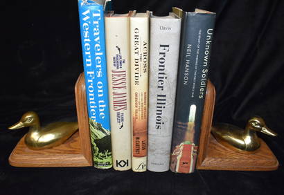
5 Books About the Old West Jesse James etc. Near Fine to New ConditionNorth American Artifact Auctions4.7(198)See Sold PriceApr 20, 2024
Foulis.- Corsica.- Boswell (James) An Account of Corsica, the journal of a tour to that island; andForum Auctions4.3(53)See Sold PriceFeb 29, 2024
Kent & Sussex.- Moss (W.G.) The History and Antiquities of the Town and Port of Hastings, 1824; andForum Auctions4.3(53)See Sold PriceFeb 29, 2024
Robert Benard (1734 - 1777) - Set of 9 Copperplate Engravings - Architecture, Masonry, Quarry withProverde Auctions4.3(3)See Sold PriceFeb 28, 2024
Robert Benard (1734 - 1777) - Set of 9 Chemical Engravings - Alchemical symbols - Utensils forProverde Auctions4.3(3)See Sold PriceFeb 28, 2024
Robert de Vaugondy - Map of Canada - Mer de l' Ouest or Sea of the West and a Northwest PassageProverde Auctions4.3(3)See Sold PriceFeb 28, 2024
Robert H Labberton - Map of The Territory of the Present United States - The territory of theProverde Auctions4.3(3)See Sold PriceFeb 28, 2024


![[MAP]. ANVILLE. West Indies. 1794 (1 of 2)](https://p1.liveauctioneers.com/514/38482/16709452_1_x.jpg?height=282&quality=70&version=1363615005)