SoldGIBSON, John: Atlas Minimus, or A New Set of PocketGIBSON, John: Atlas Minimus, or A New Set of Pocket Maps, of the Several Empires, Kingdoms, and States of the Known World, L, Piguemit, 1792. 16mo. With hand coloured frontis + 52 hand coloured maps.See Sold Price
SoldGibson (John) Atlas MinimusGibson (John) Atlas Minimus, or a new set of Pocket Maps of the Several Empires, Kingdoms and States of the known World, revised, corrected and improved by Eman. Bowen, first edition, second iSee Sold Price
SoldWorld.- Gibson (John) Atlas Minimus, or a New Set ofWorld.- Gibson (John) Atlas Minimus, or a New Set of Pocket Maps ... of the known World... Revis'd, Corrected and Improv'd by Eman: Bowen, engraved throughout with frontispiece, calligraphic title, prSee Sold Price
SoldGibson (John) - Atlas Minimus,or a New set of Pocket maps of the Several Empires, Kingdoms and States of the Known World, with Historical Extracts, new edition revised by Emanuel Bowen, frontispiece, engraved title, 52 engraved maSee Sold Price
SoldAtlases.- Gibson (J.) Atlas Minimus, 1758.Gibson (John) Atlas Minimus, or a New Set of Pocket Maps ... of the known World ... revis'd, corrected and improv'd by Eman: Bowen, first edition, engraved title, frontispiece, preface leaf, index leaSee Sold Price
Sold(John, engineer) Atlas Minimus, revised by EmanuelGibson (John, engineer) Atlas Minimus, revised by Emanuel Bowen, hand-coloured engraved title, frontispiece and 52 maps hand-coloured in outline, engraved preface and index, slightly browned,See Sold Price
SoldGIBSON, JOHN; and BOWEN, EMANUEL. Atlas Minimus, or aGIBSON, JOHN; and BOWEN, EMANUEL. Atlas Minimus, or a New Set of Pocket Maps of the Several Empires, Kingdoms and States of the Known World, With Historical Extracts Relative to Each. Drawn and EngravSee Sold Price
SoldGibson & Morden Maps, Italy & UKHand colored engravings (2). "Naples and Sicily", Emanuel Bowen and John Gibson, from "Atlas Minimus", London, with a page of text and photocopy of the Atlas cover. Sight 4"h x 3"w, frame 9"h x 7.7See Sold Price
Sold(2) ATLAS MINIMUS MAP PAGES, J. GIBSON & E. BOWEN(lot of 2) Framed hand colored pages from the Atlas Minimus by John Gibson (British, 1750-1792) and improved by Emanuel Bowen (English, 1694?-1767), comprising: (1) "Turky in Asia", plate 30; (1) "EgySee Sold Price
Atlante - Gibson, JohnAtlas Minimus: or, a New Set of Pocket Maps, Of various Empires, Kingdoms and States,of the known world [...] ... revis'd, corrected and improv'd by Eman: Bowen J. Newbery, [1758]. In 16°. Elegante aSee Sold Price
Gibson Atlas Minimus: West IndiesMap Title: West Indies Cartographer: Gibson Place / Date: London / 1758/1792 Size: 3 3/4" x 2 1/2" Condition: b&w; light overall age toning A later edition of the delightfully detailed miniature WestSee Sold Price
SoldAtlases.- Seller (John) Atlas Minimus or a Book ofAtlases.- Seller (John) Atlas Minimus or a Book of Geography, engraved title, frontispiece, double-page world map (with neatly repaired tear) and 49 single-page maps only with facing tables (lacking BSee Sold Price
SoldGibson (J.) - Atlas Minimus Illustratus: Containingfrontis piece and 50/52 maps, only, lacking Europe and Sweden & Norway, also lacking the letterpress for Denmark, original vellum backed boards, rubbed and chipped, 16mo., T. Carnan and F. Newbery, 16See Sold Price
Gibson: West Indies Map from Atlas Minimus, 1758Title/Content of Map: West Indies Cartographer: Gibson Place & Date: London / 1758/1792 Size: 3 3/4" x 2 1/2" Condition: b&w; light overal age toning A later edition of the delightfully detailed miniaSee Sold Price
Gibson: West Indies map from the Atlas MinimusCartographer: Gibson Place/Date: London / 1758/1792 Size: 3 3/4" x 2 1/2" Condition: b&w; light overall age toning A later edition of the delightfully detailed miniature West Indies map from Gibson'sSee Sold Price
SoldFlamsteed (John) Atlas Coelestis, 1781.Flamsteed (John) Atlas Coelestis, engraved portrait by George Vertue after T. Gibson, engraved vignette on title, headpiece, tail-piece and initial, and 27 double-page engraved star maps (on 28 sheetsSee Sold Price
SoldCanada.- Gibson (John) A New and Correct Map of theCanada.- Gibson (John) A New and Correct Map of the Isles of New Found Land, Cape Breton &c., with the Provinces of Nova Scotia, engraved map on laid paper with watermark of a crown and the initials GSee Sold Price
SoldAmerica.- Colonial Southern United States, Florida.-NO RESERVE America.- Colonial Southern United States, Florida.- Gibson (John) A Map of the New Governments, of East & West Florida, with inset plan of the Harbour and Settlement of Pensacola, publisheSee Sold Price
SoldRiver St. Laurence, Sillery-Falls of Montmorency MapAn Authentic Plan of the River St. Laurence (Lawrence) from Sillery to the Falls of Montmorency, Gibson, John, Gentleman's Magazine, 1st Edition, 1759, Original black ink engraving with hand-coloring.See Sold Price
SoldTwo Early English Maps of the United States,Two Early English Maps of the United States, GUTHRIE, William. – DARTON, William. A Map of the United States of America, Agreeable to the Peace of 1783. and GIBSON, John. The British Governments inSee Sold Price
SoldGibson Map of the MidwestGIBSON, John (active 1750-1792). [Colonial America]. Midwest.Engraved Map. London: 1763. 8 1/3" x 10" sheet. Relief shown pictorially. Shows the area from Canada to the Gulf of Mexico and the Rocky MoSee Sold Price
SoldJohn Gibson, Drawn and Engraved, Hand Colored Map ofProvenance: The Estate of Nancye Miller Circa 1750 16" tall x 17" wideSee Sold Price
A Group of Three Maps by John Gibson, 18th Century,A Group of Three Maps by John Gibson, 18th Century, Including 'A Map of 100 Miles Round Boston', 'A Map of the Icy Sea in with the Land Waters and Others', and 'The British Government in North AmericaSee Sold Price
John Gibson, "Map of the Present U. S." 1763, showingJohn Gibson, "Map of the Present U. S." 1763, showing Louisiana, Virginia, and Carolina, black and white map of the Indian tribes in the U.S., presented in a gilt distressed frame, H.- 7 1/8 in., W.-See Sold Price
17TH C. MAP OF THE BERKSHIRES BY JOHN SPEED, FRAMEDThomaston Place Auction Galleries4.4(386)See Sold PriceFeb 24, 2024
ATLAS of ANTIENT GEOGRAPHY by SAMUEL BUTLER 1843John McInnis Auctioneers,LLC4.6(502)See Sold PriceFeb 24, 2024
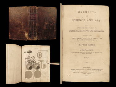
1803 Imison Science & Art Steam Engines Optics Electricity CLOCKS IllustratedSchilb Antiquarian Rare Books4.8(421)See Sold PriceMar 31, 2024
General Books - Nicolson - The Counties of Britain - A Tudor Atlas by John SpeedTimeLine Auctions Ltd.4.5(183)See Sold PriceMar 08, 2024
Walter Tittle. 14 etchings and lithographs. Portraits of notables. To include: John Garret, SirTremont Auctions4.6(293)See Sold PriceFeb 25, 2024
John Ogilby (Scottish, 1600-1676) engraving and signed folio dated 1671CV Auction LLC4.4(34)See Sold PriceMar 09, 2024
West Indies Islands. Guadaloupe. | Mariegalante &C. | Antigua.Jasper524.5(9.8k)See Sold PriceFeb 27, 2024
John Gibson Anaheim Mighty Ducks Signed Alt Retro Adidas Jersey3 Kings Auction4.3(194)See Sold PriceFeb 28, 2024
John Gibson signed 8x10 photo PSA/DNA Anaheim Ducks Autographed3 Kings Auction4.3(194)See Sold PriceFeb 27, 2024
John McHale/Gene Mauch/Bob Gibson Montreal Expos Logo Baseball 12-sig-Becket RevGolden Air Auctions4.4(257)See Sold PriceFeb 25, 2024
GIBSON JOHN LENNON 2007 LES PAUL JUNIOR CHERRY RED 099/300Los Angeles Antiques 4.3(12)See Sold PriceMar 10, 2024
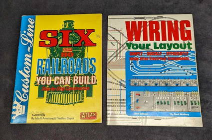
Atlas Railroads You Can Build & Wiring Your Layout SoftcoversRapid Estate Liquidators and Auction Gallery4.5(1.1k)See Sold PriceMar 03, 2024
DALTON, JOHN CALL. 1825-1889. Topographical Anatomy of the Brain. Philadelphia: Judah Dobson, 1...Bonhams4.1(305)See Sold PriceJun 18, 2024