SoldJigsaw Maps.- Geo. Philip & SonJigsaw Maps.- Geo. Philip & Son, Philips' Map Building Puzzle. England & Wales; Scotland,2 coloured maps mounted on wood and dissected as jigsaw puzzles, each 315 x 240mm., in original cardboSee Sold Price
SoldJigsaw. World - A mixed group of 3 jigsaw maps,including McLoughlin Bro's Dissected Map of the World, an incomplete double-hemisphere world map by George Philip & Son, and another puzzle box containing 4 maps, India, South Africa, Canada, and AustSee Sold Price
SoldJigsaw. England and Wales. - A group of 6 jigsaw maps,including Eslick's Patent Dissected Map, by Philip, Son & Nephew, 420 x 310mm., in original flat box with pictorial lid ; with 2 other Philip's jigsaw maps, one for the P. & T. (Philip & Tacey) SeriesSee Sold Price
SoldJigsaw. Philip (George, & Son) - Double-sided jigsaw2 jigsaw maps, Europe and Scotland, each with the world on Mercator's projection on verso, colour-printed maps mounted on wood and dissected, unboxed ; with a G.W. Bacon map of Canada, backed with theSee Sold Price
Jigsaw. Philip (George, & Son) - England and Wales;2 ccolour-printed jigsaw maps, each c.300 x 225mm. and the reverse, both laminated or varnished, in original matching flat wooden boxes with sliding lids mounted with key maps, c.1900; with a later PhSee Sold Price
SoldJigsaw. Philip (George, Son & Nephew) - Eslick's Patentengraved jigsaw map of France dissected by department, the adjoining countries and sea undissected, 240 x 315mm., mounted on wood, slight surface dirt and light spotting, publisher's inkstamp lower leSee Sold Price
SoldJigsaw. Philip (George, & Son) - England and Wales,engraved jigsaw map with originl hand-colouring, mountd on wood and dissected, 665 x 540mm., slight browning to some piece edges, supplied with the same undissected map as key, this with some splittinSee Sold Price
SoldBlock puzzle. - A mixed group of puzzle maps,including a boxed block puzzle set of maps by Frémin, with 5 key maps; a similar but smaller block puzzle set of George Philip and Son maps; with 2 other block puzzles and 2 jigsaw maps, various puSee Sold Price
Philip & Tacey Ltd., England and Wales jigsawPhilip (George & Son) Publishers. England and Wales,jigsaw map from the P. & T. Series of Cut-Out Maps, cut along county boundaries, colour-printed map, mounted on plywood backing, 310 x 235mmSee Sold Price
SoldPhilip (George, & Son) - Globe Trotter,consisting of four lithographed maps, with accompanying jigsaw puzzles in original coloured boxes, presented in card box with lithographed map and title pasted on, with printed rules pasted on undersiSee Sold Price
SoldJigsaw. Philip (George, & Son.) - Europe,for Philips Series of Dissected Maps, lithographed map printed in colours, mounted on wood and dissected, 330 x 430mm., slight surface dirt and spotting, preserved in contemporary wooden box with pictSee Sold Price
SoldGeo. Philip & Son for Georama illuminated globeGeo. Philip & Son for Georama illuminated globe, 20th c., tripod library stand, 52"h x 19"dia.See Sold Price
SoldPhilips New Library Map of London and its Environs,Philips New Library Map of London and its Environs, folding map, George Philip & Son, London, The London Geographical Institute, 152cm x 117cm - Stock Ref:6678-1See Sold Price
SoldGeorge Philip & Son, map block puzzle with 6 differentHeading: (Maps & Atlases) Author: Title: George Philip & Son Map Block Puzzle Place Published: London & Liverpool Publisher:George Philip & Son Date Published: No date Description:See Sold Price
Philip & Son: Map of Commercial Middle East, 1925TITLE/CONTENT OF MAP: 'South-Western Asia - Commercial Development; Inset maps of Palestine; Lower Iraq; Wales' Middle East/SW Asia. Commercial. Mining & Agricultural production DATE PRINTED: 1925 IMASee Sold Price
Philip & Son: Map of Central America Caribbean, 1914TITLE/CONTENT OF MAP: 'Central American and West Indian Ports; Inset The Pacific Coast from San Diego to Vancouver; San Francisco; Aleutian; The Pacific Coast from Seattle to Dutch Harbor; Bermudas; KSee Sold Price
Philip & Son: Map of Eastern Australia/New Zealand 1914TITLE/CONTENT OF MAP: 'Eastern Australian and New Zealand Ports; Inset Otago Harbour; Auckland; Port Lyttelton; Port Adelaide; Brisbane; Port Phillip; Port Jackson; Hobart;' This map is folding henceSee Sold Price
Sold1852 EASTERN HEMISPHERE MAP BY G. PHILIP & SONHand colored and engraved map of the eastern hemisphere by George Philip and Son, Liverpool. Matted, 22.5 x 20.5 inch sight size. Not examined outside wrapping, appears excellent.See Sold Price
SoldA group of 3 boxed sets of cube maps,The Geographical Cubes, with maps by George Philip & Son, some spotting and browning, preserved in contemporary pictorial box, some joins weak, lacking two edges of lid ; Atlas Géographique, unattrSee Sold Price
SoldWar. - A smal, mixed, group of war maps,including Stanford's War Map of Russia, 1854; The Daily Mail War Map, by George Philip & Son, 1914; The Daily Telegraph War Map of Europe, by Alexander Gross, 1918; Guerra Europea, an Italian photo-boSee Sold Price
Philip & Son: Antique Map of Indian Ocean, 1914Title/Content of Map: 'The Indian Ocean - Cables and Wireless Stations; Pacific Ocean; The Malay Archipelago showing Visibility of Land' Date Printed: c1914 Image Size: Approx 35.5 x 46.5cm, 14 x 18.2See Sold Price
Philip & Son: Antique Map of the United States, 1881Map: United States. Texas Pacific Railroad Reaches Forth Worth Publication Date: 1881 ca. Authors: GEORGE PHILIP & SON, PHILIP, GEORGE & SON Publisher: GEORGE PHILIP & SON Size: Folio – 19.75 H x 24See Sold Price
SoldANTIQUE FOLD-OUT COLOR MAP OF PRUSSIA WITH INDEX c1898Book Details: This lot includes the late 19th-century fold-out map of Prussia shown in the corresponding image(s). This color map, published by George Philip & Son, Ltd. of London, and a title in PhiSee Sold Price
SoldLondon.- Philip (George, & Son) Philip's New Map ofLondon.- Philip (George, & Son) Philip's New Map of London and It's Environs, from the New Ordnance Survey including the area under the jurisdiction of the Metropolitan Board of Works, showing from ChSee Sold Price
Civil War First Regiment Infantry Engraving of Phillip Sheriden Second Lieutenant Hand SignedCowboy Joe's Antiques4.7(202)See Sold PriceFeb 27, 2024
[LITHOGRAPHY]. [GEO. S. HARRIS & SONS CIGAR BOX LABELS & TR...Potter & Potter Auctions4.6(550)See Sold PriceMar 07, 2024
[LITHOGRAPHY]. [TOBACCO]. “St. Julien Time 2:11 ¼ ”. Cigar ...Potter & Potter Auctions4.6(550)See Sold PriceMar 07, 2024
Mitchell - Map of the City of Washington (Washington, DC)Trillium Antique Prints & Rare Books4.5(33)See Sold PriceFeb 24, 2024
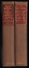
Scarce 1st ed. “Life Histories of African Game Animals?? – T. Roosevelt, E. HellerJasper524.5(9.9k)See Sold PriceFeb 27, 2024
Blackie (Pub) 1882 Folio Map. West USA - Pacific StatesAlbion Auctions4.7(341)See Sold PriceMar 01, 2024
Blackie (Pub) 1882 Folio Map. Chinese Empire and JapanAlbion Auctions4.7(341)See Sold PriceMar 01, 2024
Blackie (Pub) 1882 Folio Map. East Indies - Indian ArchipelagoAlbion Auctions4.7(341)See Sold PriceMar 01, 2024
Blackie (Pub) 1882 Folio Map. United States of North AmericaAlbion Auctions4.7(341)See Sold PriceMar 01, 2024
Blackie (Pub) 1882 Folio Map. West India Islands & Central AmericaAlbion Auctions4.7(341)See Sold PriceMar 01, 2024
Blackie (Pub) 1882 Folio Map. World on Mercators ProjectionAlbion Auctions4.7(341)See Sold PriceMar 01, 2024
Blackie (Pub) 1882 Pair of Folio Maps. Italy - North & SouthAlbion Auctions4.7(341)See Sold PriceMar 01, 2024


![[LITHOGRAPHY]. [GEO. S. HARRIS & SONS CIGAR BOX LABELS & TR... (1 of 1)](https://p1.liveauctioneers.com/928/318880/171361059_1_x.jpg?height=282&quality=70&version=1707501302)
![[LITHOGRAPHY]. [TOBACCO]. “St. Julien Time 2:11 ¼ ”. Cigar ... (1 of 1)](https://p1.liveauctioneers.com/928/318880/171361086_1_x.jpg?height=282&quality=70&version=1707501302)