ATLAS of ANTIENT GEOGRAPHY by SAMUEL BUTLER 1843John McInnis Auctioneers,LLC4.5(505)See Sold PriceFeb 24, 2024
18TH C. ANTIQUE MAP: FRENCH & INDIAN WAR, FRAMEDThomaston Place Auction Galleries4.4(394)See Sold PriceFeb 24, 2024
Rand McNally Railroad Map Cabinet w/ 21 Railroad MapsRail & Road Auctions4.6(165)See Sold PriceMar 08, 2024
Keith Haring - Ink on New York Map, Best Buddies, Inscribed, Signed, and DatedSapphire Auction Gallery4.1(67)See Sold PriceMar 02, 2024
LATE 17TH C. FRENCH MAP OF THE NEW WORLD BY ALEXIS-HUBERT JAILLOT (1632-1712)Thomaston Place Auction Galleries4.4(394)See Sold PriceFeb 24, 2024
Central Railroad of New Jersey Map of Sandy Hook Route-ca. 1903JM Hobby Supply and Railroad Artifact Auctions4.4(127)See Sold PriceFeb 24, 2024
Lot of Six Mixed Atlas Box Cars-HO Scale-New in BoxJM Hobby Supply and Railroad Artifact Auctions4.4(127)See Sold PriceFeb 25, 2024
Rand McNally/Santa Fe Railroad Map of Iowa-1912JM Hobby Supply and Railroad Artifact Auctions4.4(127)See Sold PriceFeb 24, 2024
NICOLAES VISSCHER (NETHERLANDS, 1618-1709) MAP OF THE NEW WORLDThomaston Place Auction Galleries4.4(394)See Sold PriceFeb 24, 2024
17TH C. WORLD MAP BY NICOLAES VISSCHER (NETHERLANDS, 1618-1709)Thomaston Place Auction Galleries4.4(394)See Sold PriceFeb 24, 2024
Lot of Six Mixed Atlas Cabooses-HO Scale-New in BoxJM Hobby Supply and Railroad Artifact Auctions4.4(127)See Sold PriceFeb 25, 2024
SoldCollection of 18thC Engraved MapsCollection of approximately 200+ 18th century engraved maps on laid paper, with Latin descriptions, each 8 3/4" x 11 1/8" (sheet).See Sold Price
Sold(ATLAS) DELISLE, GUILLAUME. A bound collection of 28(ATLAS) DELISLE, GUILLAUME A bound collection of 28 engraved maps, hand-colored in outline, largely after Delisle (Paris, 1745), but with examples by Nicholas Sanson and Robert de Vaugondy as well. FoSee Sold Price
Sold[CANADA & NORTH AMERICA] A collection of 13 maps[CANADA & NORTH AMERICA] A collection of 13 engraved maps. Early 19th century. Various dimensions (approx. 30 x 25 cm). Various conditions. Includes: Northern Hemisphere, Illman & Pilbrow. New York. *See Sold Price
SoldCollection of 2 Thomas Jefferys Maps, circa 1772Thomas Jefferys (British, 1719-1771). A collection of two copper plate engraved maps by noted English cartographer Thomas Jefferys (British, 1719-1771), comprising "South America"-1772, published in �See Sold Price
SoldCollection of Pennies with State Map Engraved on Each.Collection of Pennies with State Map Engraved on Each. Good Condition. Frame Measures 10-1/8 Inches by 8-1/8 Inches. Shipping $20.00See Sold Price
Sold3 ANTIQUE HAND COLORED COPPER ENGRAVED MAPSA collection of three antique hand colored copper engraved maps. Ht: 20.75" Wd: 25.75" (largest, framed)See Sold Price
SoldHandcolored engraved map Ortelius Abraham 1527-98Handcolored engraved map Ortelius Abraham 1527-98 Fessae et Marocchi regna Africae Celeberr, 16th century. sight size 14 1/2" x 19 1/4" Provenance: Collection of Anne Jones Willis and the late John RaSee Sold Price
Sold(Captain James) A Collection of Voyages round theCook (Captain James) A Collection of Voyages round the World...containing a complete Historical Account of Captain Cook's First, Second, Third and Last Voyages, 6 vol., 148 engraved maps and pSee Sold Price
SoldKitchin - 10 Engraved Maps from 'A General Atlas'Thomas Kitchin (or Thomas Kitchen) (1719-1784), 10 Engraved Maps from A General Atlas, Describing the Whole Universe: Being a Complete and New Collection of The Most Approved Maps Extant; Corrected wiSee Sold Price
SoldKnox (John) - A New Collection of Voyages, Discoveries7 vol., 48 engraved maps and plates only (of 49, lacking the General Plan of London in vol.7), some browning, bookplate of Sir Gervase Clifton to front pastedown, contemporary speckled calf, joints crSee Sold Price
SoldIndia.- Churchill (Awnshaw and John) A CollectionIndia.- Churchill (Awnshaw and John) A Collection of Voyages and Travels...,vol. 3 only (including coasts of Malabar and Cormandel and Cylon), numerous engraved maps, plans and views, many folSee Sold Price
SoldAmos Doolittle, engraved map with hand colored lineAmos Doolittle, engraved map with hand colored line outline, Vermont from actual survey. 15" x 12 1/4" Property from Credit Suisse's Americana CollectionSee Sold Price
Sold18TH C. COLORED ENGRAVED MAP, HOMANNO/UKRANIAc. 1720, Johann Baptiste Homanno (1663-1724) 19 by 22.75 in. (image), framed under glass Prov.: Daphne Farago collection, Providence RISee Sold Price
SoldEarly Charleston South Carolina Engraved Map1747 by Bowen, London. "The Town and Harbour of Charles Town in South Carolina". fourth plan of Charleston. image size: H4 5/8" W5 7/8" Private Collection of Dr. Charles Webb, Campobello, South CaroliSee Sold Price
SoldTavernier (John Baptiste) A Collection of severalTavernier (John Baptiste) A Collection of several Relations & Treatises Singular and Curious,first edition in English, advertisement leaf at beginning and another at end, folding engraved mapSee Sold Price
SoldAntique Map: Imperii Turcarum Arabum et PersarumCOVENS and MORTIER. Imperii Tucarum Arabum et Perarum. Double-page engraved map, 505x580 mm, wide margins; hand-colored in outline. Amsterdam, circa 1720.See Sold Price
SoldJohn Thomson, Spanish North America, double pageJohn Thomson, Spanish North America, double page engraved map of Texas and Mexico, sight size 20 3/4" x 25". Provenance: Property from the Credit Suisse Americana Collection.See Sold Price
Sold18th c. Map of America- Emanuel Bowen18th c. Map- ''A New and Accurate Map of America''- engraved map, 1748, from John Harris- ''Complete Collection of Voyages and Travels'', short repaired separation at top of centerfold. 14 3/8 x 17 5/See Sold Price
Sold(Capt. James) and G.W. Anderson. A new, authenticCook (Capt. James) and G.W. Anderson. A new, authentic and complete collection of voyages round the world, double-page engraved maps, and c.150 plates, fraying at margins, some ff. becoming lSee Sold Price
SoldHerman Moll, Map of Scotland, 1714Property of a Private Collection, Savannah, GA (British, 1654?-1732), The North Part of Great Britain Called Scotland, 1714, engraved map with outline color, matted and framed. Frame size: 32 1/2 in.See Sold Price
SoldThree 19th C. Maps & Two 19th C. Prints**Originally Listed At $100** Europe, Ireland and Germany, ca. 19th century CE. A collection of printed materials: two printed German maps, one print of an older engraved map, and two prints of engravSee Sold Price
SoldCarte de l'Islande, Iceland Map, Bellin, 1760Carte de l'Islande. A dramatic, highly detailed and beautifully engraved folding map of Iceland, from Prevost d'Exiles' influential collection of travel narratives, Histoire Generale des Voyages. TheSee Sold Price
Sold(Capt. James) and G.W. Anderson. A New, AuthenticCook (Capt. James) and G.W. Anderson. A New, Authentic and Complete Collection of Voyages round the World, 155 engraved plates, folding map, map torn without loss, creased, a little worn at heSee Sold Price
SoldAntique Engraved and Tinted Maplate 18th/early 19th century. Latin map of the Mediterranean by Jannes Jansjonius. framed: H21 1/4" W25 1/2" Private Collection of Dr. Charles Webb, Campobello, South Carolina.See Sold Price
17th Century Hand Colored Engraved Map of GermanyGlobal Auctions Company4.3(36)See Sold PriceMar 03, 2024
18th Century Hess Germany Hand colored Engraved MapGlobal Auctions Company4.3(36)See Sold PriceMar 03, 2024
Hand Colored Engraved Map of Europe, Jean Baptiste Bourguignon Anville 1754Global Auctions Company4.3(36)See Sold PriceMar 03, 2024
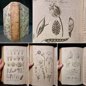
1797 Universal Magazine BOTANY PLATES Flowers FRUIT 12 Copper Engraved PlatesPrivate NY Collection4.2(22)See Sold PriceMar 01, 2024
Strickler, Rare - San Francisco, CaliforniaTrillium Antique Prints & Rare Books4.5(33)See Sold PriceFeb 24, 2024
Map: An 18thC engraved map of Bedfordshire titled An Accurate Map of the County of Bedford DividedClaydon Auctioneers Ltd4.3(125)See Sold PriceFeb 26, 2024
1816 MAP SOUTHERN PART OF RUSSIA or MUSCOVY in EUROPE copper engraving ANTIQUEJasper524.5(9.9k)See Sold PriceFeb 27, 2024
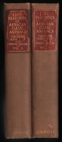
Scarce 1st ed. “Life Histories of African Game Animals?? – T. Roosevelt, E. HellerJasper524.5(9.9k)See Sold PriceFeb 27, 2024
Churchill & Nieuhof 1744 Folio Map. Cape of Good Hope, South AfricaAlbion Auctions4.7(341)See Sold PriceMar 01, 2024
Churchill & Nieuhof 1744 Folio Map. Batavia Indonesia East IndiesAlbion Auctions4.7(341)See Sold PriceMar 01, 2024
Churchill & Nieuhof 1744 Map. Batavia Jakarta IndonesiaAlbion Auctions4.7(341)See Sold PriceMar 01, 2024


![[CANADA & NORTH AMERICA] A collection of 13 maps (1 of 2)](https://p1.liveauctioneers.com/1124/187577/94368854_1_x.jpg?height=282&quality=70&version=1607095126)