SoldMap of New York Bay. North America. 1839.Print of steel engraving titled „Plan de la baie de New-York“.Drawn by unknown.Engraved by Blondeau.From „Etats-Unis D‘Amerique by M. Roux de Rochelle. Published by Firmin didot freres. Paris.See Sold Price
SoldAn Accurate Map of New York. Aug. 1780.AN ACCURATE MAP OF NEW YORK IN NORTH AMERICA, FROM A LATE SURVEY. Shows “Line Claim’d by Jersey in 1719,” “Partition Line in 1769,” “Boundary Line Claim’d by N York,” etc., with no borSee Sold Price
SoldEarly Map of North AmericaEarly Map of North America. New York, New Jersey and part of Pennsylvania. c. 1776. 55" x 21 1/2". A Prominent Buffalo, NY Family.See Sold Price
SoldVintage Map Print - America - Map of Manhattan - New York City - United StatesTitle: Vintage Map Print - America - Map of Manhattan - New York City - United States Date/Period: 1938 Dimension: 33 cm x 26 cm Material: Paper Additional Information: Vintage map of Manhattan. ThisSee Sold Price
SDUK: Antique Map of United States East Coast, 1844Title/Content of Map: 'NORTH AMERICA, SHEET VI., New York, Vermont, Maine, New Hampshire, Massachusetts, Connecticut, Rhode Island, New Jersey' Date Printed: This map was originally published by BaldwSee Sold Price
SoldColton: Antique Map of North America, 1859Title/Content of Map: North America by Colton Date Printed: 1859 Cartographer: H.J. Colton Material/Medium: Paper Size: 17 1/2" x 15" Hand colored, engraved Map. Published in New York in Colton's 'GenSee Sold Price
SoldUSA.New York Maine Massachusetts Connecticut New JerseyTITLE/CONTENT OF MAP: 'NORTH AMERICA, SHEET VI., New York, Vermont, Maine, New Hampshire, Massachusetts, Connecticut, Rhode Island, New Jersey' The top image on the right hand side shows the entire maSee Sold Price
SDUK: Antique Map of Northeast United States, 1846TITLE/CONTENT OF MAP: 'NORTH AMERICA, SHEET VI., New York, Vermont, Maine, New Hampshire, Massachusetts, Connecticut, Rhode Island, New Jersey' DATE PRINTED: 1846 IMAGE SIZE: Approx 36.5 x 33.5cm, 14.See Sold Price
SoldCHOROGRAPHICAL MAP OF THE PROVINCE OF NEW YORK IN NORTHCHOROGRAPHICAL MAP OF THE PROVINCE OF NEW YORK IN NORTH AMERICA, FOR MAJOR GENERAL WILLIAM TYRON, GOVERNOR OF NY, 1779 (REPRINTED BY THE TOWN OF LA GRANGE, SESQUICENTENNIAL COMMITTEE, 1971), MOUNTED OSee Sold Price
SoldSAUTHIER, CLAUDE JOSEPH. A Chorographical MapSAUTHIER, CLAUDE JOSEPH. A Chorographical Map of the Province of New-York in North America, Divided into Counties, Manors, Patents and Townships. Large engraved 6-sheet map joined, dissected to form 4See Sold Price
SoldLot/3 Antique Maps of United States, Albany New YorkLot of three antique maps. A large hanging map of North America and Central America. United States Ornamental map with Presidents around the border. Hanging map of Albany New York by Jay Gould. All wiSee Sold Price
SoldJohn Carey. North America map(English, 1754-1835). "Part of North America comprehending Ohio, New England, New York, New Jersey, Pennsylvania, Maryland, Virginia, Carolinas & Georgia" (sic) hand colored map, circa 1782, 9 1/2 x 1See Sold Price
SoldLot 6 New York Vintage Maps. Framed. Huntington.Lot 6 New York Vintage Maps. Framed. Huntington. Port Jefferson. North Hempstead. Islip. (2) River Head. Professionally matted & framed in Tiger Maple. -- Dimensions: Image Size: H: 15 inches: W: 21.5See Sold Price
SoldHinton, map of New York City, 1776ANONYMOUS (British, Late 18th Century). [Map] A Plan of the City and Environs of New York in North America. Engraving from the Universal Magazine, November 1776. London: J. Hinton, 1776. 12 1/4" x 15See Sold Price
Sold(Maps and Charts, North America), Speed, John 1552(Maps and Charts, North America), Speed, John 1552-1629), A Map of New England and New York, London, Thomas Bassett and Richard Chiswell, 1676, engraved by F. Lamb, double page with old hand coloring,See Sold Price
Sold(3pc) MAPS OF NEW YORK: JOHN MONTRESORIncluding; "A Plan of the City of New York & Its Environs to Greenwich", for D.T. Valentine's Manual 1855; Bernard Ratzer,[29-3/4 x 23-3/4 in, framed]; "Plan of the City of New York in North America SSee Sold Price
SoldGREAT LAKES. Upper Canada districts <1849 Lake HuronTITLE/CONTENT OF MAP: 'NORTH AMERICA, SHEET III., Upper Canada and New Brunswick with parts of New York, Pennsylvania and Michigan' The map shows the historic districts of Upper Canada (Ontario) as thSee Sold Price
SDUK: Antique Map of Upper Canada & Great Lakes, 1846Title/Content of Map: 'NORTH AMERICA, SHEET III., Upper Canada and New Brunswick with parts of New York, Pennsylvania and Michigan' The map shows the historic districts of Upper Canada (Ontario) as thSee Sold Price
GREAT LAKES. Upper Canada districts <1849 Lake HuronReserve Reduced! TITLE/CONTENT OF MAP: 'NORTH AMERICA, SHEET III., Upper Canada and New Brunswick with parts of New York, Pennsylvania and Michigan' The map shows the historic districts of Upper CanadSee Sold Price
Sold5 pieces. Hand-Colored Engraved Maps - North Amer5 pieces. Hand-Colored Engraved Maps - North America: Moll, Herman. New England, New York, New Jersey and Pennsylvania & C." [London], [ca. 1740]. 7 x 10 1/2 inches; 200 x 270 mm. Old color. Framed. *See Sold Price
SoldColton: Antique Map of British North America, 1861Map: North America British Russian Danish Date Printed: 1861 Cartographer: J.H. Colton Material/Medium: Paper Size: 17 1/2" x 14" Hand colored, steel engraved. Printed in New York. From Colton's 'GeneSee Sold Price
De L'isle: Antique Map of North America, 1730Title/Content of Map: North America by De L'isle Date Printed: c1730 Cartographer: Guillaume De L'Isle Size: 21" x 25" Material/Medium: Provenance: New York Hand colored coppeprlate engraved influentiSee Sold Price
SoldTWO 18TH C. MAPS *NEW ENGLAND, NEW YORK, NEW JERSTWO 18TH C. MAPS *NEW ENGLAND, NEW YORK, NEW JERSEY, & PENSILVANIA (SIC) BY H. MOLL, GEOGRAPHER* AND NORTH AMERICA SIGNED NAME UNCERTAIN; 14 1/2 IN X 9 1/4 IN & NA IS 10 1/4 IN X 8 INSee Sold Price
SoldNorth America by De L'isleTitle/Content of Map: North America by De L'isle Date Printed: c1730 Cartographer: Guillaume De L'isle Material/Medium: Paper Size: 21" x 25" Provenance: New York Hand colored copperplate engraved. InSee Sold Price
Vintage County Map Of NY State Plate EngravingThe Benefit Shop Foundation Inc.4.3(2.9k)See Sold PriceFeb 28, 2024
1849 THE NEW-ENGLAND MERCANTILE UNIONNorth American Artifact Auctions4.7(198)See Sold PriceApr 20, 2024
The Art of Hunting Big Game in North America 1967North American Artifact Auctions4.7(198)See Sold PriceApr 20, 2024
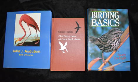
3 Vintage Hardback Bird Books AudubonNorth American Artifact Auctions4.7(198)See Sold PriceApr 20, 2024
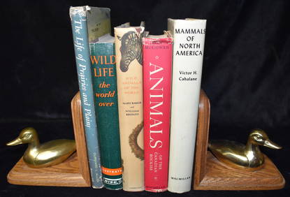
5 Mid-Century Books on Animals all in Excellent Condition.North American Artifact Auctions4.7(198)See Sold PriceApr 20, 2024
5 Vintage Books About Birds, Fish & Animals all in Excellent ConditionNorth American Artifact Auctions4.7(198)See Sold PriceApr 20, 2024
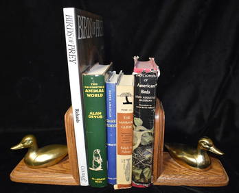
5 Hardback Books on Birds, Animals & Nature all in Excellent condition.North American Artifact Auctions4.7(198)See Sold PriceApr 20, 2024
Audubon's Animals - The Quadrupeds of North America 1954 Folio Size BookNorth American Artifact Auctions4.7(198)See Sold PriceApr 20, 2024
A Field Guide To Wildflowers, Birds & Birds Nesting 3 Books from the Peterson Field Guide SeriesNorth American Artifact Auctions4.7(198)See Sold PriceApr 20, 2024
Arrowsmith & Lewis - Map of PolynesiaTrillium Antique Prints & Rare Books4.5(32)See Sold PriceFeb 24, 2024
Arrowsmith & Lewis - Map of North AmericaTrillium Antique Prints & Rare Books4.5(32)See Sold PriceFeb 24, 2024
Arrowsmith & Lewis - Map of the World on Mercator's ProjectionTrillium Antique Prints & Rare Books4.5(32)See Sold PriceFeb 24, 2024
Arrowsmith & Lewis - Map of LouisianaTrillium Antique Prints & Rare Books4.5(32)See Sold PriceFeb 24, 2024
Arrowsmith & Lewis - Map of the United StatesTrillium Antique Prints & Rare Books4.5(32)See Sold PriceFeb 24, 2024
Audubon - 8 Quadruped LithographsTrillium Antique Prints & Rare Books4.5(32)See Sold PriceFeb 24, 2024
Group of Vintage travel maps and bookletsBaker's Antiques and Auctions3.2(471)See Sold PriceFeb 25, 2024
New and Correct Map of North America With the West India Islands,Jasper524.5(9.9k)See Sold PriceFeb 28, 2024
Herman Moll A New Map of Ye North Parts of AmericaWillow Auction House4.5(289)See Sold PriceMar 14, 2024
Hudson River Map & North American Postcards, 45Auctions at Showplace4.6(740)See Sold PriceFeb 13, 2025