SoldWilliam W. Mather, Geological Map of Long and StatenMATHER, William W. Geological Map of Long and Staten Island with Environs of New York. New York: 1842. 2 sheets joined, float-mounted and framed (25 x 54 4/8 inches; 22 2/8 x 50 4/8 inches to the neatSee Sold Price
SoldMather Map of Long IslandMather, William W. (1804-1859). Geological Map of Long and Staten Island with the Environs of New York. Lithographed map with hand color. New York, 1842. 25" x 53 1/2" sheet, 30" x 58 1/2". Landmark mSee Sold Price
Mather Map of Long Island, 1842MATHER, William W. (1804-1859). Geological Map of Long and Staten Island with the Environs of New York. Lithographed map with hand color. New York, 1842. 25" x 53 1/2" sheet, 30" x 58 1/2". Landmark mSee Sold Price
Landmark map of Long Island; the earliest L.I. wall mapMATHER, William W. (1804-1859). Geological Map of Long and Staten Island with the Environs of New York. Lithographed map with hand color. New York, 1842. 25" x 53 1/2" sheet, 30" x 58 1/2" framed. LanSee Sold Price
SoldWilliam W. MatherGeological Map of Long and Staten Island with Environs of New York; New York, 1842 Hand colored Lithograph Paper size: 54"x25"; Framed.See Sold Price
SoldGeological Map of Long and Staten Island with EnvironsWilliam W. Mather (1804-1859). Hand-colored Lithograph. New York, 1842. 25 1/8 x 53 3/4 inches, 30 x 58 3/8 inches framed. Magnificent 1842 Large-Scale Geological Map of Long Island. This 1842 map wasSee Sold Price
SoldMather's Map of NY, 1842Geological Map of Long and Staten Island with the Environs of New York. William W. Mather (1804-1859). Lithographed map with hand color New York, 1842. 25 1/2 x 52 1/2 inches sheet, 29 1/2 x 57 1/2 inSee Sold Price
Landmark Map of Long IslandGeological Map of Long and Staten Island with the Environs of New York. William W. Mather (1804-1859). Lithographed map with hand color. New York, 1842. 25 1/2 x 53 inches sheet, 30 1/2 x 58 1/2 incheSee Sold Price
SoldLandmark map of Long Island by MatherGeological Map of Long and Staten Island with the Environs of New York. William W. Mather (1804-1859). Lithographed map with hand color. New York, 1842. 25 1/2 x 53 inches sheet, 30 1/2 x 58 1/2 incheSee Sold Price
SoldMather Map of Long IslandGeological Map of Long and Staten Island with the Environs of New York. William W. Mather (1804-1859). Lithographed map with hand color. New York, 1842. 25 1/2 x 53 inches sheet, 30 1/2 x 58 1/2 incheSee Sold Price
SoldNew York State Geology 19th Century BookNatural History of New York. Geology. William W. Mather. New York: 1843. Numerous illustrated plates and maps, but lacking large Long Island map.See Sold Price
SoldThree NY natural history books including: "NaturalThree NY natural history books including: "Natural History of New-York / Part 1 / Comprising The Geology Of The First Geological District.", by William W. Mather, and -printed in Albany by Carroll & CSee Sold Price
Book "Geology of New-York / Part 1 / Comprising TheBook "Geology of New-York / Part 1 / Comprising The Geology Of The First Geological District.", by William W. Mather, and printed in Albany by Carroll & Cook 1843 - first edition. The spine is markedSee Sold Price
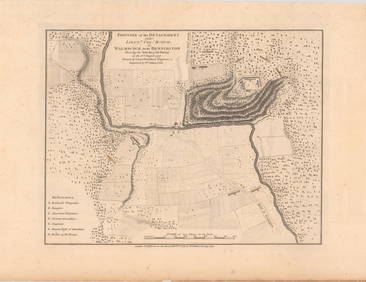
SoldFaden Map of New York, 1776FADEN, William (1749-1836). A Plan of New York Island, with part of Long Island, Staten Island & East New Jersey. Engraved map. London: William Faden, October 19th, 1776. 26 3/4" x 21 3/4" sheet, 39"See Sold Price
SoldGeological Map of the United States and British NorthTitle: Geological Map of the United States and British North America... Publication Date: 1855 Cartographer: JOHNSTON, W. & A.K./H.D. ROGERS Publisher: WILLIAM BLACKWOOD & SONS Size (inches): 20 x 24.See Sold Price
Sold1776 William Faden Plan of New York Island MapDESCRIPTION: A Plan of New York Island with part of Long Island, Staten Island & East New Jersey, with a particular Description of the Engagement on the Woody Heights of Long Island, between FlatbushSee Sold Price
Faden Map - Battle of Long IslandFADEN, William (1749-1836). A Plan of New York Island, with part of Long Island, Staten Island & East New Jersey. Engraved map with original hand color. London: William Faden, October 19th, 1776. 30 1See Sold Price
SoldFaden Map of the Battle of Long Island, Fifth and Last StateFADEN, William (1749-1836). A Plan of New York Island, with part of Long Island, Staten Island & East New Jersey. Engraved map with original hand color. London: William Faden, October 19th, 1776. 30 1See Sold Price
Faden Revoltionary War battle mapFaden, William (1749-1836). A plan of New York Island, with part of Long Island, Staten Island & East New Jersey. Engraved map with original hand color in part above letterpress text in 4 columns. LonSee Sold Price
SoldW.G. Bonner map of Georgia,"Bonner's Map of the State of Georgia with the Addition of its Geological Features", from [Statistics of the State of Georgia,] by George White, published by W.T. Williams, 1849, Savannah, 20-3/4 x 18See Sold Price
Faden Plan of New York Island during the Revolutionary War, First StateFADEN, William (1749 - 1836). A plan of New York Island with part of Long Island, Staten Island, and East New Jersey... Engraved map with original hand color. London: Faden, Oct. 19, 1776. 20 3/4" x 1See Sold Price
SoldFramed Map of Connecticut, Rhode Island, & LongWilliams & Co. Custom Wooden Frame. Topographic map of Connecticut, Rhode Island, Long Island. Dimensions: 14x2 in L X 13.5x2 in W. good conditionSee Sold Price
Bradford: Antique Map of Southern Europe, 1835Title/Content of Map: Southern Europe Date Printed: 1835 Cartographer: T. G. Bradford Publisher: William D. Ticknor / Wiley & Long 1835 Boston/New York Size: Quarto – 7.75 H x 10.0 W Inches Page 101See Sold Price
SoldMap of New Jersey 1860, printed on paper on clothMap of New Jersey 1860, printed on paper on cloth, William Kitchell, Superintendent Geological Survey New Jersey, published by H.G. Bond, Philadelphia, 71"h x 58"wSee Sold Price
Pintail Pair by John William Luedtke (1901-1958)Copley Fine Art Auctions4.5(40)See Sold PriceFeb 24, 2024
Curlew Decoy by Capt. Joel W. Barkalow (1853-1931)Copley Fine Art Auctions4.5(40)See Sold PriceFeb 24, 2024
Birmingham.- Commercial map.- Smith (J. Pigott) To the Right Honourable William Earl of Dartmouth...Forum Auctions4.4(54)See Sold PriceFeb 29, 2024
English Sterling Silver Salver by William K. ReidWorld Auction Gallery LLC4.7(267)See Sold PriceMar 10, 2024
Antique Map - Views on the coast of Asia. J. Webber del. Engraved after J. Webber and W. Bligh.Proverde Auctions4.3(3)See Sold PriceFeb 28, 2024
14K GOLD HARDSTONE CAMEO W/ ROSE CUT DIAMONDS.William Smith Auctions4.6(147)See Sold PriceMar 06, 2024
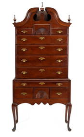
18TH C. WETHERSFIELD CT CHERRY BONNET TOP HIGHBOY.William Smith Auctions4.6(147)See Sold PriceMar 06, 2024
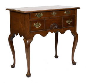
18TH C. CHIPPENDALE MA CARVED DRESSING TABLE.William Smith Auctions4.6(147)See Sold PriceMar 06, 2024
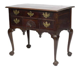
18TH C. QUEEN ANNE CHEST ON CHEST, PORTSMOUTH, NH.William Smith Auctions4.6(147)See Sold PriceMar 06, 2024
MIKIMOTO 7MM PEARL BRACELET W/ 18K SIGNATURE CLASP.William Smith Auctions4.6(147)See Sold PriceMar 06, 2024
14K TWO TONE GOLD PANTHER SLIDE PENDANT W/ CHAIN.William Smith Auctions4.6(147)See Sold PriceMar 06, 2024