Marc Chagall-Limited Edition -Paris Opera Ceiling after ChagallArt Legacy Auctions4.5(223)See Sold PriceFeb 24, 2024
Salvador Dali Pantagruel Limited Edition Lithograph Hand signed and numberedArt Legacy Auctions4.5(223)See Sold PriceFeb 24, 2024
Pablo Picasso Bouquet of Peace Collection Domaine Picasso Limited Edition on paper.Art Legacy Auctions4.5(223)See Sold PriceFeb 24, 2024
A RARE MAXFIELD PARRISH JACK AND THE BEANSTALK PRINTSoulis Auctions4.8(953)See Sold PriceFeb 24, 2024
LARGE MECHANICAL PRINT 'STARS' AFTER MAXFIELD PARRISHSoulis Auctions4.8(953)See Sold PriceFeb 24, 2024
Heinrich Aldegrever, etc. 15 old master prints. 16th-17th centuries. Aldegrever works include "ManTremont Auctions4.5(297)See Sold PriceFeb 25, 2024
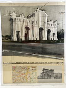
SoldMAP OF BERMUDA ISLANDS, 1902, HC LITHOGRAPHTitle: Driving and Cycling Map of the Bermuda Islands, Date: 1902, Medium: HC Lithograph, Paper size: 11 1/2 x 28, Inscribed: Publisher inentified within matrix, Condition: Good condition; folds.See Sold Price
SoldMap of Bermuda Islands, 1902Title: Map of Bermuda Islands Original engraving by George Cram Date: 1902 Dimensions: 11 x 14 inches No Reserve: This lot starts at $1 and has no reserve as a courtesy so that collectors can determinSee Sold Price
Map of MA, RI & CT. C. 1902The National Publishing Company's Railroad, Post Office, Township and Country Map of Massachusetts, Rhode Island and Connecticut. 1902. Colored lithograph. Linen backed. ; 36" x 38"See Sold Price
Bermuda Islands, 1902Original engraving by George Cram, 1902. Dimensions: 11” x 14” Shipping Domestic: Shipping rates are determind by destination. International: Foreign shipping rates are determined by destination.See Sold Price
SoldTallis: Map of Islands of the Atlantic, 1853Islands of the Atlantic - Bermuda, Canary & Azores by Tallis. Original lithograph by John Tallis & Company of London, c. 1853. Map features Azores, Madeira, Bermuda, Canary & Cape Verde Islands. VingnSee Sold Price
Vielle Map of New York CityVIELE, Egbert Ludovicus (1825-1902). Sanitary & Topographical Map of the City and Island of New York. Colored Lithograph. New York, 1865. 19 3/4" x 85 1/4" sheet, 24 1/2" x 70 1/4" framed. Comparable:See Sold Price
Viele Map of Manhattan showing Central ParkVIELE, Egbert Ludovicus (1825-1902). Sanitary & Topographical Map of the City and Island of New York. Colored Lithograph. New York, 1865. 19 3/4" x 85 1/4" sheet, 24 1/2" x 70 1/4" framed. Comparable:See Sold Price
SoldYOUNG, U.S.A. MAP, HC LITHOGRAPH, C.1843Artist: J.H. Young, Title: National Map of the United States of North America, Printmaker: J. H. Brightly, Pub: S. Augustus Mitchell, Date: C.1843, Medium: Hand-colored lithograph, Sight size: 39 x 47See Sold Price
Bermuda Islands, 1902Original engraving by George Cram, 1902. Dimensions: 11” x 14” No Reserve Buyer pays shipping. This item ships from Ocean View, DE.See Sold Price
Bermuda Islands 1897Title/Content of Map: Bermuda Islands 1897 Date Printed: 1897 Material/Medium: Paper Size: approx. 11x14 inches Additional Info: Crams Universal Atlas- Chicago Reserve: $30.00 Shipping: Domestic: FlatSee Sold Price
Bermuda Islands 1897Title/Content of Map: Bermuda Islands 1897 Date Printed: 1897 Material/Medium: Paper Size: approx. 11x14 inches Additional Info: Crams Universal Atlas- Chicago Reserve: $30.00 Shipping: Domestic: FlatSee Sold Price
Bermuda Islands 1897Title/Content of Map: Bermuda Islands 1897 Date Printed: 1897 Material/Medium: Paper Size: approx. 11x14 inches Additional Info: Crams Universal Atlas- Chicago Reserve: $30.00 Shipping: Domestic: FlatSee Sold Price
Bermuda Islands 1897Title/Content of Map: Bermuda Islands 1897 Date Printed: 1897 Material/Medium: Paper Size: approx. 11x14 inches Additional Info: Crams Universal Atlas- Chicago Reserve: $30.00 Shipping: Domestic: FlatSee Sold Price
SoldANTIQUE HAWAII HAWAIIAN ISLANDS LITHOGRAPH MAP AUGUSTTRACED BY F.L. LOWELL HAWAIIAN GOV. SURVEY AUGUST 1901 - "JULIUS BIEN & CO. PHOTO. LITH." (1826 - 1909)See Sold Price
Luzon, Philippine Islands Map, 1902Luzon, Philippine Islands. J. Martin Miller, Matthews-Northrup Co. J. Martin Miller. 1902. Atlas map from The Twentieth Century Atlas of the commercial, geographical and historical world. Mercator andSee Sold Price
A Map of the Bermuda Islands, Height of frame 25 1A Map of the Bermuda Islands, framed. Height of frame 25 1/2 x width 37 inches.See Sold Price
SoldMap: Boston, 1875, HC Lithograph, J.H. Bufford'sTitle: Map of Boston, Printmaker: J.H. Bufford's, Pub: Sampson Davenport & Co., Date: 1875, Medium: Lithograph with hand color, Paper size: 34 x 28, Inscribed: Publisher and lithographer identified wiSee Sold Price
SoldMap Of The Bermuda Islands 1947Map of the Bermuda or Somers Islands. 1947. Published by the J. L. Smith co. Philadelphia, PaSee Sold Price
SoldMap: Newport, Rhode Island, HC EngravingArtist: Charles Blaskowitz, Title: A Plan of the Town of Newport in Rhode Island, Printmaker: William Faden, Pub: William Faden, Date: C1877, Medium: Engraving with hand color, Paper size: 14 1/4 x 20See Sold Price
Decorative antique print of Michigan mapLitho's One H.C. lithograph map of Michigan and Wisconsin by Mitchell 1864, New YorkH-16 x 13 Original Antique Print.See Sold Price
SoldDecorative antique print of Ohio mapLitho's One H.C. lithograph map of Ohio and Nebraska by Mitchell 1864, New YorkH-16 x 13 Original Antique Print.See Sold Price
Decorative antique print of Indiana mapLitho's One H.C. lithograph map of Indiana and Ohio by Mitchell 1864, New YorkH-16 x 13 Original Antique Print.See Sold Price
SoldRussell'S Map Of Boston, C1872, HC LithographTitle: Russell's Map of Boston, Printmaker: J. Mayer & Co., Pub: B.B. Russell, Date: C1872, Medium: Lithograph with hand color, Paper size: 17 x 26 , Inscribed: Publisher and lithographer identified wSee Sold Price
North Atlantic Ocean. Bermuda Islands - Hamilton I.Title/Content of Map: North Atlantic Ocean. Bermuda Islands - Hamilton I. Date: 3/1/1963 Cartographer: HYDROGRAPHIC OFFICE. ROYAL NAVY/H.P. DOUGLAS Size: 26 X 33 "Hamilton Harbour surveyed by CaptainSee Sold Price
RARE 1638 HONDIUS MAP OF BERMUDA, FRAMEDThomaston Place Auction Galleries4.4(393)See Sold PriceFeb 24, 2024
Vintage Full Color World Map LithographThe Benefit Shop Foundation Inc.4.3(2.9k)See Sold PriceFeb 28, 2024
Nova Totius Full Color Geographical World MapThe Benefit Shop Foundation Inc.4.3(2.9k)See Sold PriceFeb 28, 2024
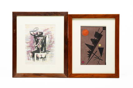
Signed Abstract Lithograph H.C Or Hors d'Commerce Signed Lower Right In PencilRbfinearts4.5(578)See Sold PriceFeb 24, 2024
Christo Vladimirov Javacheff (1935-2020) and Jeanne-Claude Denat de Guillebon (1935-2009), known asNeely Auction4.6(224)See Sold PriceFeb 25, 2024
1853 Colton's Railroad & Township Map of Massachusetts, Rhode Island, and ConnecticutRail & Road Auctions4.6(165)See Sold PriceMar 07, 2024
Vaillant - Hawaii: Stranding in the Sandwich Islands (Echouage aux Iles Sandwich). 43Trillium Antique Prints & Rare Books4.5(32)See Sold PriceFeb 24, 2024
1750 Bowen Map of Bermuda and St. Kitts -- A New & Accurate Map of Bermudas or Sommer's Islands...Jasper524.5(9.9k)See Sold PriceFeb 27, 2024
Blackie (Pub) 1882 Folio Map. West India Islands & Central AmericaAlbion Auctions4.7(341)See Sold PriceMar 01, 2024
Stanford, Edward 1901 Large Map. Geological Map of the British IslesAlbion Auctions4.7(341)See Sold PriceMar 01, 2024
Perry, Matthew C. 1856 Large Map. Shah Bay, Lew Chew I. JapanAlbion Auctions4.7(341)See Sold PriceMar 01, 2024
ANTIQUE ILLUSTRATED HANDBOOK OF GEOGRAPHY AND TRAVEL IN ASIA, VOLUME 2, 1896NY Elizabeth 4.2(86)See Sold PriceMar 03, 2024