SoldJH COLTON 1853 TEXAS FOLDING MAPJH COLTON 1853 TEXAS FOLDING MAP, VERY GOOD OVERALL CONDITION, SOME LIGHT FOXING SPOTS ON OUTER BORDER, MAP MEASURES 14" X 17" OPEN... * BOTH PRINTED DATES ON MAP ARE 1853.See Sold Price
SoldRare Colton folding map of U.S. 1853Heading: Author: Colton, Joseph Hutchins Title: The United States of America 1853 Place Published: New York Publisher:Published by J.H. Colton Date Published: 1853 Description:See Sold Price
Sold* COLTON, J.H. Colton's Map of the United States of* COLTON, Joseph Hutchins (1800-1893). Colton's Map of the United States of America, including Canada and a large portion of Texas. New York, 1854. Engraved folding map, overall 1665 x 2068 mm, hand-cSee Sold Price
SoldWashington and Oregon Map [J.H. Colton, 1853]J.H. Colton Washington and Oregon map, dated 1853. Measures 14" x 17.25" (sheet size). G-Vg/Vg condition. Unframed, loose and not mounted or glued down. We ship all items in this auction in-house.See Sold Price
Colton's Railroad & Township Map of Ohio 1852Title: Colton's Railroad & Township Map of the State of Ohio Author: Colton, J.H. Description: Engraved folding map, hand-colored. 60.5x70 cm. (24x27½") including the decorative border. With brown giSee Sold Price
SoldFlorida Lithograph MapFlorida, No. 32. Hand-colored lithographed map. New York: J.H. Colton, 1853. 12 1/2 x 15 1/4 inches visible, 23 x 25 inches framedSee Sold Price
SoldFolding map of U.S. by J.H. Colton 1855Title: The United States of America Author: Colton, J.H. Description: Lithographed map, hand-colored. 35.5x60 cm. (13¾x23¾") plus decorative border.Excellent map showing the odd configurations of thSee Sold Price
Folding map of U.S. by J.H. Colton 1855Title: The United States of America Author: Colton, J.H. Description: Lithographed map, hand-colored. 35.5x60 cm. (13¾x23¾") plus decorative border.Excellent map showing the odd configurations of thSee Sold Price
SoldEarly pocket map of MinnesotaHeading: Author: Colton, J.H. Title: Minnesota Place Published: New York Publisher:J.H. Colton & Co Date Published: 1855 Description: Folding color map, 12 x 15 inches. FolSee Sold Price
SoldHuc's Journey through Chinese Empire 1855Title: A Journey Through the Chinese Empire Author: Huc, [Evariste Regis] Description: 2 volumes. 421; 422 pp. Folding lithographed map by J.H. Colton & Co. 7½x4¾, original blue blindstamped cloth,See Sold Price
Sold[Map]. 1857 J. H. Colton Pocket Map of Texas. Ne[Map]. 1857 J. H. Colton Pocket Map of Texas. New York: J.H. Colton & Co., 1857. Measures 16.75" x 14" when folded out. Hand painted, with marked railroads, cities, towns, rivers, etc. Two insetsSee Sold Price
SoldHuc's Journey through Chinese Empire 1855Title: A Journey Through the Chinese Empire Author: Huc, [Evariste Regis] Description: 2 volumes. 421; 422 pp. Folding lithographed map by J.H. Colton & Co. 7½x4¾, original blue blindstamped cloth,See Sold Price
Burr's smaller map of New York, 1936Heading: Author: Burr, David Title: New York Place Published: New York Publisher:J.H. Colton & Co. Date Published: 1836 Description: Folding pocket map, 18¼ x 21½ inches, wSee Sold Price
Early pocket map of MinnesotaHeading: Author: Colton, J.H. Title: Minnesota Place Published: New York Publisher:J.H. Colton & Co Date Published: 1855 Description: Folding color map, 12 x 15 inches. FolSee Sold Price
SoldNew Illustrated Map of the WorldJ.H. Colton (1800 – 1893). New York: J.H. Colton, 1853. 44 1/2 x 33 5/8 inches. Not a cartographer or engraver himself, Colton’s initial business practice mostly involved purchasing the copyrightsSee Sold Price
SoldBurr's folding map of U.S. 1833Heading: Author: Burr, David H. Title: United States Place Published: New York Publisher:J.H. Colton & Co. Date Published: 1833 Description: Copper-engraved map, hand-colorSee Sold Price
Burr's folding map of U.S. 1833Heading: Author: Burr, David H. Title: United States Place Published: New York Publisher:J.H. Colton & Co. Date Published: 1833 Description: Copper-engraved map, hand-colorSee Sold Price
Colton's Township Map of the State of IowaTitle: Colton's Township Map of the State of Iowa Publication Date: 1855 Publisher: J.H. COLTON & CO. Size: 24 x 29 "compiled from the United States Surveys, & other authentic sources." Folding map ofSee Sold Price
Sold1856 MAP OF FLORIDA Colton, Hand-ColoredAntebellum, dated 1856 folding map of Florida published by J.H.Colton, hand-colored and in magnificent condition. Book measures 5" x 3-1/2". Map extends to nearly 17" wide. Part of a large estate collSee Sold Price
SoldJ.H. Colton, Colton's Map of the State of WestCOLTON, Joseph Hutchins (1800 - 1893). Colton's Map of the State of West Virginia. New York: G.W. & C.B. Colton & Co., 1866. Single sheet (25 ½ x 28 ½ inches). Folding engraved map of West VirginiaSee Sold Price
SoldFolding map of New York 1859Title: Colton's Railroad & Township Map of the State of New York, with Parts of Adjoining States and Canada Author:Colton, J.H. Description:Lithographed map, hand-colored. 53x64 cm. (20¾x25¼"), foldSee Sold Price
SoldJ. H. Colton's Map of United StatesIncluding US, British Provinces, Mexico, and West Indies. Published by J.H. Colton, New York, 1853. 59" x 53".See Sold Price
SoldColton (J.H., publisher) Map of the USAColton (J.H., publisher) Map of the United States of America,folding engraved map, original hand-colouring, vignette border, 865 x 1055mm., folding into original blind-stamped roan, lettered iSee Sold Price
SoldJ.H. Colton 'La Crosse & Milwaukee Rail Road' MapJ.H. Colton 'La Crosse & Milwaukee Rail Road' Map c.1853, drawn by George W. Colton, engraved by J.M. Atwood New York, depicting railroad routes throughout La Crosse and Milwaukee Wisconsin Height: 12See Sold Price
Cleveland and Mahoning RR 2nd Annual Report-December 20, 1854JM Hobby Supply and Railroad Artifact Auctions4.4(126)See Sold PriceFeb 24, 2024
1853 Colton's Railroad & Township Map of Massachusetts, Rhode Island, and ConnecticutRail & Road Auctions4.6(165)See Sold PriceMar 07, 2024
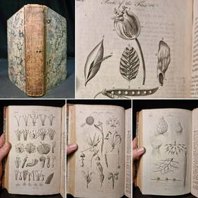
1797 Universal Magazine BOTANY PLATES Flowers FRUIT 12 Copper Engraved PlatesPrivate NY Collection4.2(21)See Sold PriceMar 01, 2024
1749-1771 HISTORY OF ROMAN EMPERORS 12 VOLUMES antique ILLUSTRATED w/ MAPSJasper524.5(9.7k)See Sold PriceFeb 27, 2024
Bible, English.- Bible (The): that is, the Holy Scriptures contained in the Olde and Newe Testament,Forum Auctions4.3(52)See Sold PriceFeb 29, 2024
Kent & Sussex.- Moss (W.G.) The History and Antiquities of the Town and Port of Hastings, 1824; andForum Auctions4.3(52)See Sold PriceFeb 29, 2024
EARLY COLONIAL WEST AFRICA. Empires of Sokoto Gando Mas.Tribes.Fellatah 1882 mapJasper524.5(9.7k)See Sold PriceFeb 28, 2024
AFRICA. Pre 'Scramble for Africa'. BARTHOLOMEW 1876 old antique map plan chartJasper524.5(9.7k)See Sold PriceFeb 28, 2024
JOYCE WIELAND: TRUE PATRIOT LOVE. 1971, 1st. ED.Toronto Book Auctions4.3(13)See Sold PriceMar 07, 2024


![Washington and Oregon Map [J.H. Colton, 1853] (1 of 4)](https://p1.liveauctioneers.com/5755/117825/60527194_1_x.jpg?height=282&quality=70&version=1520551011)


![[Map]. 1857 J. H. Colton Pocket Map of Texas. Ne (1 of 2)](https://p1.liveauctioneers.com/906/165466/83729356_1_x.jpg?height=282&quality=70&version=1586352505)