Sold19th Century Map - A Plan of the Town, New HavenMap of plan of New Haven. Paper in linen. 19th century. Map opening size : H 7-3/4", W 6"; frame size: H 14", W 12". Excellent condition. Professionally framed. Collection of Laura Mitler. Please refeSee Sold Price
SoldHand-colored map, Chester, EnglandFramed hand-colored lithograph map, ""Chester, England,"" British School, 19th century, signed ""J.M. Gahey"" within print lower left, overall: 31""h x 40""wSee Sold Price
SoldWilliam Henry Brown - Silhouette of Dewit ClintonWilliam Henry Brown, American - (1808-1883). Portrait of Dewitt Clinton. Printed on fabric and embellished with needlework. Map of New York hangs in the background. 19th century. Framed size H 13" W 1See Sold Price
Sold19th Century Print Portland Maine from Cape ElizabethPortland Maine from Cape Elizabeth. Jones and Newman, 128 Fulton St NY. Engraved by E. Whitfield. Hand colored lithograph. American, 19th century. Excellent condition. Framed size H 31-3/4" W 48". SigSee Sold Price
SoldMap of New York, after Mathias SeuterMap of New York, after Mathias Seuter 19th centuryentitled NOVI BELGII, AMERICA SEPTENTRIONALI, engraving with hand colored accents, framed.image size: H19" W22"See Sold Price
SoldEnglish Needlework Map of EnglandEnglish Needlework Map of England Late 18th/early 19th century Framed. 21 x 20 inches (53 x 51 cm).See Sold Price
SoldFramed wall paper fragment of the "GRAND CANAL", earlyFramed wall paper fragment of the "GRAND CANAL", early 19th century - Framed in a 19th century New England grain painted frame. Sight size 16.25" x 11". Several creases and repairs, otherwise good conSee Sold Price
SoldPhelps' Map of the United States, 1834Phelps’ Map of the United States from the Best Authorities. H. Phelps (fl. mid-19th century). Hand-colored Lithographed map. New York: H. Phelps, 1834. 30 x 39 1/2 inches sheet, 34 3/4 x 44 1/2 inchSee Sold Price
SoldA GROUP OF 13 BEAUTIFULLY FRAMED 17TH-19TH CENTUA GROUP OF 13 BEAUTIFULLY FRAMED 17TH-19TH CENTURY HAND-COLORED MAPS including Russia, c. 1750, after M. deL'Isle, 7 inches x 10.25 inches; also from Travels to the Source of the Missouri River and AcSee Sold Price
Sold1879 MAP, WARREN'S NEW ENGLAND OR EASTERN STATESFramed hand colored map, "Map of New England or Eastern States", page 33, "Common School Geography", David M. Warren (1820-1861), Cowperthwait & Co., Philadelphia, 1879, showing Maine, New Hampshire,See Sold Price
SoldSampler New Haven Connecticut Mary Parker, 183119th Century New England framed sampler executed by school girl Mary F. Parker, aged 11 years 1831. Family register Mary chronicles the birth and deaths of Parker & Polly Peck family of Wolcott, New HSee Sold Price
SoldFour Antique Hand Colored MapsA grouping of four small framed hand-colored engraved maps to include New England and New York by John Seller, A Mapp of the World by John Seller, Terra Firma, and Moscovia (Moscow) of Russia. All inSee Sold Price
SoldGroup of six 19th century hand colored engraved maps toGroup of six 19th century hand colored engraved maps to include New Jersey, Wisconsin, Florida, Eastern United States, Maryland and Michigan. sight size: 14" x 11 1/2" to 11 1/2" x 14".See Sold Price
SoldAntique Hand Colored Maps of Westchester County NYAntique Hand Colored Maps of Westchester County NY. This lot includes four 19th century hand colored maps from the "Atlas of New York and Vicinity" by F.W. Beers. Includes one map of Mamaroneck/Rye NeSee Sold Price
SoldAntique Hand Colored Maps of Westchester County NYAntique Hand Colored Maps of Westchester County NY. This lot includes four 19th century hand colored maps from the "Atlas of New York and Vicinity" by F.W. Beers. Includes one map of Bedford, one mapSee Sold Price
SoldAntique Hand Colored Maps of Westchester County NYAntique Hand Colored Maps of Westchester County NY. This lot includes four 19th century hand colored maps from the "Atlas of New York and Vicinity" by F.W. Beers. Includes one map of Port Chester, oneSee Sold Price
SoldAntique Hand Colored Maps of Westchester County NYAntique Hand Colored Maps of Westchester County NY. This lot includes four 19th century hand colored maps from the "Atlas of New York and Vicinity" by F.W. Beers and the Planning Board/Technical AdvisSee Sold Price
SoldA Framed 19th Century Map of Florida, Height of printA Framed 19th Century Map of Florida, circa 1855, lithography printing by Bowne & Hasbrouck, New York, titled "U.S. Coast Survey...Sketch F... with a General Reconaissance of the Coast of Florida 1848See Sold Price
SoldEARLY 19TH C NEW ENGLAND SAMPLER FRAMEDEarly 19th Century New England sampler wrought by Sarah Ann MacKenzie 'in the 9th year of her age', with colorful river and tree border, four poems, alphabet, etc., 21" x 18". Framed. Some fading andSee Sold Price
SoldAmerican School, 19th Century New England MountainAmerican School, 19th Century New England Mountains Unsigned, inscribed on the stretcher. Oil on canvas, 28 x 40 in. (71.0 x 101.5 cm), framed. Condition: Lined, retouch.See Sold Price
SoldEarly 19th Century Hand-Colored Map of the UnitedEarly 19th Century Hand-Colored Map of the United States, matted and framed, 12 x 15.5" (sight). Printed by Thos. T. Ash, 139 Chestnut St. Phila. Missouri is shown with modern boundaries (24th stateSee Sold Price
SoldAmerican School mid-19th century New England landscapeAmerican School mid-19th century New England landscape with figures by a barn with horse. Hay wagon in the barn. Oil on canvas. Unmounted. Framed. Slight buckling at center top. In need of cleaning. PSee Sold Price
SoldJOHN WILLIAMSON - NEW ENGLAND LANDSCAPE PAINTING JohnJohn Williamson - American 1826-1885 - 19th Century New England Landscape with lake painting. Oil on canvas laid on board. Signed lower left. 9" x 12". 13" x 16" Framed. Born at Toll Cross, near GlasgSee Sold Price
SoldMitchell's Large Scale 19C Map of New York 1858Mitchell's Large Scale Map of New York 1858. The large 19th century map is titled Mitchell's County and Township Map of the State of New York Showing the Adjoining Portions of New England New Jersey aSee Sold Price
Folk Artist Max Mays' First Baptist Church printBert Gallery Studio Sales4.4(18)See Sold PriceFeb 27, 2024
Pr New England Bow Back Windsor SidechairsSchmidt's Antiques Inc. Since 19114.8(431)See Sold PriceMar 02, 2024
18th/19th Century New England Queen Anne tilt top tea table with birdcage, beaded edge top, singleNeely Auction4.6(224)See Sold PriceFeb 25, 2024
17th Century Hand Colored Engraved Map of GermanyGlobal Auctions Company4.3(36)See Sold PriceMar 03, 2024
[MAP]. [ALBRIZZI, Giambatista, 1698-1777]. Carta Geografica...Potter & Potter Auctions4.6(545)See Sold PriceMar 07, 2024
Mitchell - Map of the City of Washington (Washington, DC)Trillium Antique Prints & Rare Books4.5(32)See Sold PriceFeb 24, 2024
SPONGE-PAINTED TRUNK New England, Early 19th Century Height 12". Width 26.5". Depth 13".Eldred's4.7(419)See Sold PriceMar 07, 2024
OVAL NEW ENGLAND TAVERN TABLE Early 19th Century Height 26.5". Top 34.5" x 25.75".Eldred's4.7(419)See Sold PriceMar 07, 2024
Two Hand-Colored 19th Century Maps of New Orleans and Louisiana, Larger- H.- 12 1/2 in., W.- 15 1/2Crescent City Auction Gallery4.3(231)See Sold PriceMar 08, 2024
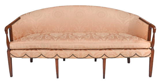
New England Federal Figured Maple Inlaid Mahogany SofaBrunk Auctions4.6(470)See Sold PriceMar 08, 2024
Late 18th century map of England and Wales sampler and two printsFellows4.3(159)See Sold PriceMar 05, 2024
Rare 19thc Colton Map, Argentine Republic, Chile, Uruguay, PataguayConnoisseur Auctions3.9(336)See Sold PriceMar 16, 2024
19th century New England oil painting with winter scene small town MEFJasper524.5(9.9k)See Sold PriceMar 07, 2024
19th century oil painting Winter Scene lillian Lewis listed artistJasper524.5(9.9k)See Sold PriceMar 07, 2024


![[MAP]. [ALBRIZZI, Giambatista, 1698-1777]. Carta Geografica... (1 of 1)](https://p1.liveauctioneers.com/928/318880/171361280_1_x.jpg?height=282&quality=70&version=1707501302)