SoldDunn (Samuel) British Empire in North AmericaDunn (Samuel) A Map of the British Empire in North America,improved from the surveys of Capt. Carver, from the Arctic to Florida, and from Greenland and Newfoundland to Saskatchewan, with decoSee Sold Price
SoldSamuel Dunn of British Empire in North AmericaSamuel Dunn, "A Map of the British Empire in North America; By Samuel Dunn, Mathematician", London, Robert Sayer, 1774, engraved map in outline color, 18 1/2 in. x 12 in., unframedSee Sold Price
SoldSamuel Dunn, engraved map of the British EmpireSamuel Dunn, engraved map of the British Empire in North America, published in 1776, 19 1/2'' x 12 1/2''.See Sold Price
SoldDunn Map of the British Empire in North AmericaDunn, Samuel (d. 1794). A Map of the British Empire in North America... Engraved map with original hand color in outline. London: Sayer & Bennett, 1776. 21 3/4" x 15" sheet. This uncommon map is basedSee Sold Price
SoldSamuel Dunn, "A Map of the British Empire in NorthSamuel Dunn, "A Map of the British Empire in North America," 20th c., after the 1776 original, framed, H.- 19 3/4 in., W.- 12 3/4 in.See Sold Price
Sold18th Century Map of North AmericaMap titled "A map of the British Empire in North America" by Samuel Dunn, published by Robert Sayer, London, 1774. Plate measures 19.25" x 12.25" on sheet measuring 21.5" x 15". Map presents hand-coloSee Sold Price
SoldMap of the British Empire of North America, SamuelMap of the British Empire of North AmericaSamuel Dunn, published by Robert Sayer, London, 1774Matted and framed.20 in. x 13 in. (sight)See Sold Price
SoldSAMUEL DUNN (BRITISH, D. 1794) MAP OF THE UNITED STATESSAMUEL DUNN (BRITISH, D. 1794) MAP OF THE UNITED STATES, hand-colored engraving on paper, titled "A New Map of the United States of North America with the British Dominions on that Continent & c." FouSee Sold Price
SoldSAMUEL DUNN HAND COLORED PRINTED MAPSAMUEL DUNN, HAND COLORED PRINTED MAP, IMAGE: H 19", W 12 1/2", "A NEW MAP OF THE UNITED STATES OF NORTH AMERICA":"--- with the British Dominions on the continent"; printed for Robert Sayer; framed.See Sold Price
SoldDunn Map of North AmericaNorth America, As Divided amongst the European Powers…Samuel Dunn (fl. 1774). Engraved Map. London: Sayer & Bennett, 1774. 19 3/4 x 12 3/4 inches visible, 23 1/2 x 16 3/4 inches framedSee Sold Price
MAP OF THE BRITISH EMPIRE IN NORTH AMERICA, 1776…THOMASThomas Jefferys - Map Of The British Empire In North America, 1776 - 25 7/8 X 40 In. - This Giclée On Canvas Is Gallery Stretched And Ready To HangSee Sold Price
MAP OF THE BRITISH EMPIRE IN NORTH AMERICA, 1776…THOMASThomas Jefferys - Map Of The British Empire In North America, 1776 - 25 7/8 X 40 In. - This Giclée Print Is Gallery Stretched And Ready To HangSee Sold Price
SoldAccurate Map of the British Empire in North AmericAccurate Map of the British Empire in North America - as settled by the Preliminaries in 1762 - J. Gibson sculp. - 8 7/8" x 11 1/4"See Sold Price
THOMAS JEFFERYS - MAP OF THE BRITISH EMPIRE IN NOThomas Jefferys - Map Of The British Empire In North America, 1776 - Giclée On Canvas - 28 1/2 X 44 In. A Giclée Print Is The Highest Quality Print Available Today. Because There Is No Visible Dot SSee Sold Price
SoldA Thomas Kitchin Hand-Colored Engraving: A New MA Thomas Kitchin Hand-Colored Engraving: A New Map of the British Empire in North ASee Sold Price
Sold1972 A Map of the British Empire in America PoppleDESCRIPTION: 1972 Folio of Henry Popple's 1733 Map of the British Empire in North America. Each map section with support binding. Published by Harry Margary Lympe Castle Kent with the assistance of ThSee Sold Price
Thomas Jefferys - Map Of The British Empire In NorthThomas Jefferys - Map Of The British Empire In North America, 1776 Size: 23 1/4 X 36 In. - This Is A Gallery Stretched Giclee Print On Canvas. The Piece Was Printed On High Quality Artist Grade 350 GsSee Sold Price
THOMAS JEFFERYS - MAP OF THE BRITISH EMPIRE IN NORTHThomas Jefferys - Map Of The British Empire In North America, 1776 - 28 1/2 X 44 In. - This Giclée Print Is Gallery Stretched And Ready To Hang Or Lean Against A Wall, Or Display On An Easel. - A GicSee Sold Price
THOMAS JEFFERYS - MAP OF THE BRITISH EMPIRE IN NORThomas Jefferys - Map Of The British Empire In North America, 1776 - Giclée On Canvas - 23 1/4 X 36 In.~~A giclée print falls between serigraph and lithograph in quality. Although they can be made oSee Sold Price
Popple (Henry) After. - Nouvelle Carte Particulièthe northeast sheet of the Dutch 4-sheet version of Popple's Map of the British Empire in North America, extending from Labrador to Cape Fear in North Carolina, and from the eastern shore of Lake OntaSee Sold Price
SoldThomas Jeffries, "A Map of the British Empire in NorthThomas Jeffries, "A Map of the British Empire in North America," 20th c., print, after the 18th c. original, presented in an ebonized frame, H.- 19 1/4 in., W.- 12 7/8 in.See Sold Price
THOMAS JEFFERYS - MAP OF THE BRITISH EMPIRE IN NORTHThomas Jefferys - Map Of The British Empire In North America, 1776 - 23 1/4 X 36 In. - This Giclée Print Is Gallery Stretched And Ready To Hang Or Lean Against A Wall, Or Display On An Easel. - A GicSee Sold Price
THOMAS JEFFERYS - MAP OF THE BRITISH EMPIRE IN NORTHThomas Jefferys - Map Of The British Empire In North America, 1776 - 23 1/4 X 36 In. - This Giclée Print Is Gallery Stretched And Ready To Hang Or Lean Against A Wall, Or Display On An Easel. - A GicSee Sold Price
THOMAS JEFFERYS -MAP OF THE BRITISH EMPIRE IN NORTHThomas Jefferys -map Of The British Empire In North America, 1776 - Giclée On Canvas -25 7/8 X 40 In. - A Giclée Print Is The Highest Quality Print Available Today. Because There Is No Visible Dot SSee Sold Price
LARGE EARLY 18TH C. DUTCH CHART OF UPPER NORTH AMERICA, PIERRE MORTIER (1661-1711), FRAMEDThomaston Place Auction Galleries4.4(386)See Sold PriceFeb 24, 2024
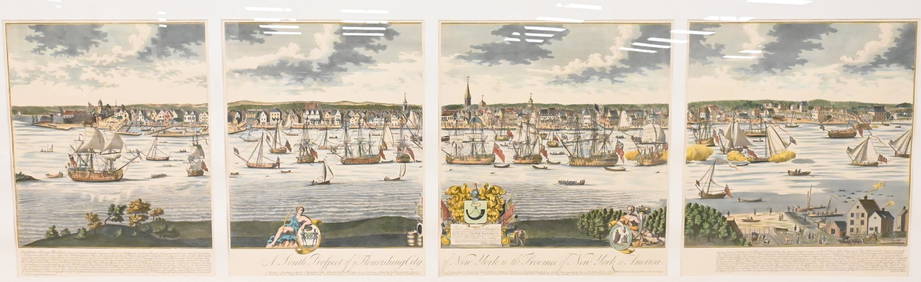
A South Prospect of Ye Flourishing City of New York in the Province of New York, North AmericaNadeau's Auction Gallery4.7(398)See Sold PriceFeb 24, 2024
ATTR TO LIBERTY COMPANY ARTS CRAFTS COPPER MIRRORAntique Arena Inc.4.5(834)See Sold PriceFeb 24, 2024
ARTS AND CRAFTS HAMMERED LAMP BY FREDRICK FIFIELDAntique Arena Inc.4.5(834)See Sold PriceFeb 24, 2024
[LITHOGRAPHY]. [NATIVE AMERICANS]. Group of Five Hand-Color...Potter & Potter Auctions4.6(538)See Sold PriceMar 07, 2024
[SHIPWRECKS]. Manuscript testimony (court duplicate) of Thomas Kent, a Black man aboard theFreeman's | Hindman4.4(1.6k)See Sold PriceFeb 27, 2024
Arrowsmith & Lewis - Map of PolynesiaTrillium Antique Prints & Rare Books4.5(28)See Sold PriceFeb 24, 2024
Arrowsmith & Lewis - Map of North AmericaTrillium Antique Prints & Rare Books4.5(28)See Sold PriceFeb 24, 2024
Arrowsmith & Lewis - Map of the World on Mercator's ProjectionTrillium Antique Prints & Rare Books4.5(28)See Sold PriceFeb 24, 2024
Arrowsmith & Lewis - Map of LouisianaTrillium Antique Prints & Rare Books4.5(28)See Sold PriceFeb 24, 2024
Arrowsmith & Lewis - Map of the United StatesTrillium Antique Prints & Rare Books4.5(28)See Sold PriceFeb 24, 2024
Mckenney & Hall - Two Octavo Volumes of Text with Rare Plate of Billy BowlegsTrillium Antique Prints & Rare Books4.5(28)See Sold PriceFeb 24, 2024
*SALE HIGHLIGHT* Wisconsin Winged Bannerstone- 2x COA-Dickey/Motley;Heartland Artifact Auctions Inc4.7(777)See Sold PriceMar 10, 2024
New and Correct Map of North America With the West India Islands,Jasper524.5(9.7k)See Sold PriceFeb 27, 2024
5 Inuit Stone Carvings - Animals, Boat, Head w/ FacesArtemis Gallery4.8(1.3k)See Sold PriceFeb 26, 2024
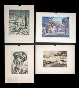
1930s American Etchings, Original Ltd. Editions (4)Artemis Gallery4.8(1.3k)See Sold PriceFeb 26, 2024
Map of United States of North America, 1785Antiques Online Auctions4.6(405)See Sold PriceMar 14, 2024
Herman Moll A New Map of Ye North Parts of AmericaWillow Auction House4.5(280)See Sold PriceMar 14, 2024


![[LITHOGRAPHY]. [NATIVE AMERICANS]. Group of Five Hand-Color... (1 of 5)](https://p1.liveauctioneers.com/928/318880/171361074_1_x.jpg?height=282&quality=70&version=1707501302)
![[SHIPWRECKS]. Manuscript testimony (court duplicate) of Thomas Kent, a Black man aboard the (1 of 5)](https://p1.liveauctioneers.com/197/319238/171468014_1_x.jpg?height=282&quality=70&version=1707520367)