SoldPalairet (Jean) Bowles's Universal AtlasBowles (Carington) Bowles's Universal Atlas,Being a Complete Collection of New and Accurate Maps of all the known countries in the World, displaying the whole surface of the Terraqueous Globe,See Sold Price
SoldBowles's Universal Atlas London ca. 1795John Palairet (1697–1774) et al., "Bowles's Universal Atlas: Being a Complete Collection of New and Accurate Maps, of all the Known Countries in the World; displaying the Whole Surface of the TSee Sold Price
SoldBowles (Carington) Bowles's Universal Atlas, beinBowles (Carington) Bowles's Universal Atlas, being a complete collection of new and accurate maps, title and 38 (of 39 ; lacking pt. 3) engraved maps, mostly folding, bound at the end C. SmithSee Sold Price
Sold(MAP) PALAIRET, JEAN. A group of 2 hand-colored maps(MAP) PALAIRET, JEAN Two engraved maps with hand-coloring from Atlas methodique, by J. Palairet, (London, c. 1755), comprising Ie. Carte de l'Europe, 1754, and Ie. Carte des sept provinces unies desSee Sold Price
SoldAmerica.- Palairet (Jean) Description AbrégéeAmerica.- French and Indian War.- Palairet (Jean) Description Abrégée des Possessions Angloises et Françoises du Continent Septentrional de l'Amérique, pour servir d'Explication &#See Sold Price
SoldBOWLES, DENMARK,NETHERLAND- (2) HC ENGR,1800Artist: Jean Palairet, Title: The Kingdom of Denmark & the Seven United Provinces - two, Pub: Bowles & Carver, Date: C.1800, Medium: Copperplate engraving with hand color, Paper size: 19 x 23 each, InSee Sold Price
Sold3 European Maps, inc. France & EnglandThree (3) European Maps, including France and England. 1st item: "Carte D'Angleterre 1754" by Jean Palairet. Colored map of England and Wales with French identifications. Counties, cities, towns, riveSee Sold Price
MAP - Western Hemisphere. PalairetWestern Hemisphere. Jean Palairet, Carte Generale de l'Amerique, 1754 (dated). Hand Color. This elegantly engraved map of the Americas was published near the start of the French and Indian War. EnglisSee Sold Price
[Maps & Atlases], Two Engraved Maps of the Black Sea,[Maps & Atlases] Two Engraved Maps of the Black Sea, Balkans, and Beyond Palairet, Jean, et al. "Carte de Hongrie" London: John and Carrington Bowles, (1755-1771). Plate: 18 9/16 x 22 in. (479 x 559 mSee Sold Price
SoldA NEW UNIVERSAL ATLAS... Phila: DeSilver, 1856.[Atlas] A NEW UNIVERSAL ATLAS Containing Maps of the various Empires, Kingdoms, States and Republics of the World… Phil: Charles DeSilver, 1856. [DeSilver entered a contract to take over publicationSee Sold Price
SoldMitchells New Universal Atlas, 1857Mitchells New Universal Atlas, 1857MITCHELL, S. AUGUSTUS. A New Universal Atlas--Containing Maps of the Various Empires, Kingdoms, States, and Republics of the World. Philadelphia: Charles Desilver, 1See Sold Price
SoldMitchel, Samuel Augustus "A New Universal Atlas"Mitchel, Samuel Augustus "A New Universal Atlas", (Baltimore, Cushings & Bailey 1859); folio; quarter-gilt pebbled sheep over gilt embossed cloth (front panel detached); Final edition of Michell's renSee Sold Price
SoldA NEW UNIVERSAL ATLAS... Phila: 1854.[Atlas]. A NEW UNIVERSAL ATLAS Containing Maps of the various Empires, Kingdoms, States and Republics of the World With a special Map of each of the United States, plans of the Cities, &c. ComprehendeSee Sold Price
SoldRand McNally Universal Atlas of the World 1899Hardcover 1899 edition. Binding in rough condition, missing end paper page in front.See Sold Price
Sold1841 CHINESE UNIVERSAL ATLASOf the Universal Dominions. Complete Atlas of the Tsing Empire completed 1852. Woodblock prints depicting maps, cut and glued onto hand colored pages with longitude and latitudes. Hardwood boards areSee Sold Price
SoldFIRST OPIUM WAR ERA 1841 CHINESE UNIVERSAL ATLASOf the Universal Dominions. Complete Atlas of the Tsing Empire completed 1852. Woodblock prints depicting maps, cut and glued onto hand colored pages with longitude and latitudes. Hardwood boards areSee Sold Price
SoldCary (John) - New Universal Atlas,engraved title and 55 double or folding map sheets, numbered 1 to 60, bound with 6 additional maps by James Wyld , comprising Upper Canada, Lower Canada, Sketch of the Niagara River (mounted on versoSee Sold Price
SoldHenry Schenck Tanner's New Universal Atlas contHenry Schenck Tanner's New Universal Atlas containing Maps of the Various Empires, Kingdoms, States, and Republics of the World, pub. 1844, Carey & Hart, Philadelphia, containing 117 hand colored mapsSee Sold Price
SoldThe universal ATLAS of the world published byThe universal ATLAS of the world published by Geographica 1923 in two volumesSee Sold Price
SoldCary's New Universal Atlas,Containing Distinct Maps of All the Principal States and Kingdoms, etc., London: Printed for J. Cary, Engraver, 1811, with 56 double-page engraved hand-colored maps on 60 numbered sheets (complete), rSee Sold Price
SoldSamuel Augustus Mitchell A NEW UNIVERSAL ATLAS 1846Title: A New Universal Atlas Containing Maps of the Various Empires, Kingdoms, States and Republics of the World with a Special Map of Each of the United States, Plans of Cities, etc. Comprehended inSee Sold Price
SoldMitchell's Universal Atlas 1847Heading: (Atlas) Author: Mitchell, S. Augustus Title: A New Universal Atlas Containing Maps of the Various Empires, Kingdoms, States and Republics of the World with a Special Map of each of the UnitedSee Sold Price
SoldMitchell, Samuel Augustus. A New Universal AtlasMitchell, Samuel Augustus. A New Universal Atlas of the World. Philadelphia: Thomas Cowperthwait & Co., 1852. Folio, disbound, with seventy of seventy-four hand-colored maps, lacking New Hampshire andSee Sold Price
SoldVOLUME-MITCHELL'S UNIVERSAL ATLAS, THOMAS COWPERTHWARTVOLUME-MITCHELL'S UNIVERSAL ATLAS, THOMAS COWPERTHWART & COMPANY, PA 1850 (LOOSE BOARDS/PAGES/INCOMPLETE)See Sold Price
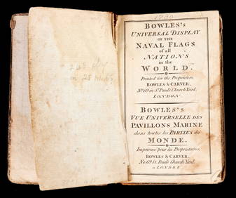
BOWLES'S UNIVERSAL DISPLAY of NAVAL FLAGS c1790John McInnis Auctioneers,LLC4.5(505)See Sold PriceFeb 24, 2024
Mitchell - Map of the City of Washington (Washington, DC)Trillium Antique Prints & Rare Books4.5(32)See Sold PriceFeb 24, 2024
Stanford, Edward 1901 Large Map. Burma and Adjacent CountriesAlbion Auctions4.6(341)See Sold PriceMar 01, 2024
Stanford, Edward 1901 Large Map. Sea of Marmara. TurkeyAlbion Auctions4.6(341)See Sold PriceMar 01, 2024
Stanford, Edward 1901 Large Map. Geological Map of the British IslesAlbion Auctions4.6(341)See Sold PriceMar 01, 2024
Stanford, Edward 1901 Large Map. Hydrographical Map of the British IslesAlbion Auctions4.6(341)See Sold PriceMar 01, 2024
Stanford, Edward 1901 Large Map. Stereographical Map of The British IslesAlbion Auctions4.6(341)See Sold PriceMar 01, 2024


![[Maps & Atlases], Two Engraved Maps of the Black Sea, (1 of 2)](https://p1.liveauctioneers.com/65/159076/80333191_1_x.jpg?height=282&quality=70&version=1578427354)