SoldNEW HISTORICAL ATLAS OF ALAMEDA COUNTY CALIFORNIA1976 reprint of the 1878 original, unpaginated folio. Measures 12.25 x 9.25 inches. We are happy to offer in-house shipping for all but very large or very fragile items. Some international orders maySee Sold Price
SoldHistorical Atlas of Alameda County, 1878Historical atlas of Alameda County, California, Thompson & West, 1878, Illustrated title page, impressive maps and views of Oakland, Alameda, Berkeley and other more obscure parts of the county, fullSee Sold Price
SoldHistorical Atlas of Alameda CountyHistorical Atlas of Alameda County, California, Thompson & West, 1878, Illustrated title page, impressive maps and views of Oakland, Alameda, Berkeley and other more obscure parts of the county, fullSee Sold Price
SoldHistorical Atlas of Alameda CountyHistorical Atlas of Alameda County, California, Thompson and West, 1878, illustrated title page, impressive maps and views of Oakland, Alameda, Berkeley and other more obscure parts of the county, fulSee Sold Price
Official Historical Atlas Map Alameda County CaliforniaOfficial and Historical Atlas Map of Alameda County, California. Compiled, Drawn and Published From Personal Examinations and Surveys. Thompson & West. Valley Publishers. Reprint. 4to. Lithographic reSee Sold Price
Official Historical Atlas Map Alameda County CaliforniaOfficial and Historical Atlas Map of Alameda County, California. Compiled, Drawn and Published From Personal Examinations and Surveys. Thompson & West. Valley Publishers. Reprint. 4to. Lithographic reSee Sold Price
Official Historical Atlas Map of Alameda County, CAOfficial and Historical Atlas Map of Alameda County, California. Compiled, Drawn and Published From Personal Examinations and Surveys. [Thompson & West]. Fresno: Valley Publishers, 1976. Profusely illSee Sold Price
Official and Historical Atlas Map of Alameda County, CaOfficial and Historical Atlas Map of Alameda County, California. Compiled, Drawn and Published From Personal Examinations and Surveys. [Thompson & West]. Bicentennial edition facsimile of the originalSee Sold Price
Official & Historical Atlas Map of Alameda County, CATitle: Official and Historical Atlas Map of Alameda County, California. Compiled, Drawn and Published From Personal Examinations and Surveys. Fresno. Valley Publishers. 1976 Author(s): Thompson & WestSee Sold Price
SoldAtlas Map of Alameda CountyTitle: Official and Historical Atlas Map of Alameda County, California Author: ** Description: 170 pp. Illustrated with 36 hand-colored maps (including 22 double-page and 3 folding), and 70 (of 71) liSee Sold Price
SoldAtlas Map of Alameda CountyTitle: Official and Historical Atlas Map of Alameda County, California Author: ** Description: 13-170 pp. Illustrated with hand-colored maps and lithographed views. (folio) 17½x15, original cloth (laSee Sold Price
SoldAtlas, Maps of Alameda County, 1878Thompson & West, ''Official and Historical Atlas Map of Alameda County California, Compiled, Drawn and Published from Personal Examinations and Surveys,'' Oakland, 1878, incomplete, rebound in buckramSee Sold Price
SoldHistorical Atlas Washtenaw County 1874Historical Atlas Washtenaw County , Michigan 1874 illustrated. Everts & Stewart. 143 pp. lower corners dog-eared from pages 126-141, 142 - transfer pages chipped lower corners. Transfer pages are blanSee Sold Price
SoldHistorical Atlas Lenawee County 1874Historical Atlas Washtenaw Country, Michigan 1874 illustrated. Everts & Stewart. 124 pp. some maps separated or torn. Residence cut from page 59. Transfer pages blank. 17.25" x 14.25" x 1". ProvenanceSee Sold Price
SoldHISTORICAL ATLAS OF DUTCHESS COUNTY NEW YORKHISTORICAL ATLAS OF DUTCHESS COUNTY NEW YORK ILLUSTRATED - READING PUBLISHING HOUSE 1876. IN GOOD ESTATE CONDITION, FROM HOUSE IN STANFORDVILLE, N.Y. BEAUTIFUL MAPS AND ILLUSTRATIONS. HARD ATLAS TO FISee Sold Price
SoldNew Historical Atlas of Rockland County New YorkNew Historical Atlas of Rockland County New York Illustrated Centennial 1876". Atlas contains maps as well as engraving of various buildings and landscapes within Rockland County. Good condition withSee Sold Price
SoldJ.D. Scott. New Historical Atlas of Montgomery County.J.D. Scott. New Historical Atlas of Montgomery County. Phila 1877. Folio. 107 pages. Occasional stains and edge tears, one map with old tape repair. Covers soiled with wear.See Sold Price
SoldNew Historical Atlas of Mercer County New Jersey.New Historical Atlas of Mercer County New Jersey. Illustrated. Everts & Stewart 1875. Complete.-- Dimensions: ---See Sold Price
Sold1876 Historical Atlas of Yates County, New York1876 Historical Atlas of Yates County, New York, Maps, Lithographic Views, Portraits, Etc., Approx. 17.5" x 14.5"See Sold Price
Sold1872 Historical Atlas of Cumberland County, PADESCRIPTION: 1872 atlas of Cumberland County, Pennsylvania. From the surveys by and under the direction of F.W. Beers. Published by F.W. Beers & Co. Includes 48 colored surveys of Cumberland Co. borouSee Sold Price
Sold1876 Historical Atlas of Lehigh County, PADESCRIPTION: 1876 historical atlas of Lehigh County, Pennsylvania. Handcolored maps throughout. Reading Publishing House. Hardbound cloth covered with leather spine and corner pieces. Gilt lettering tSee Sold Price
SoldNew Historical Atlas of Dauphin CountyDESCRIPTION: New Historical Atlas of Dauphin County, Pennsylvania by Everets & Stewart. Published and printed in Philadelphia in 1875. Embossed brown cloth boards, profusely illustrated throughout incSee Sold Price
SoldILLUS. HISTORICAL ATLAS OF WAYNE COUNTY, MICH"ILLUSTRATED HISTORICAL ATLAS OF WAYNE COUNTY, MICH", 1876, & A LAND TITLE, TWO, AS IS CONDITION:See Sold Price
Sold[New Historical Atlas of Fayette County], 1875[ATLAS]. [L.H. Everts, New Historical Atlas Of Fayette County, Ohio. 1975]. Folio. Cloth & leather binding quite worn, covers detached, lacking title page, several other defects, sold to viewing biddeSee Sold Price
General Books - Nicolson - The Counties of Britain - A Tudor Atlas by John SpeedTimeLine Auctions Ltd.4.5(183)See Sold PriceMar 08, 2024
Rand McNally & Co's New Ideal State and County Survey and Atlas 1911North American Artifact Auctions4.6(182)See Sold PriceApr 20, 2024
HAMMOND'S READY REFERENCE HISTORICAL ATLAS 1920North American Artifact Auctions4.6(182)See Sold PriceApr 20, 2024
[BLACK PANTHER PARTY]. Black is Beautiful poster. [With:] Photographic essays, incl. The VanguardFreeman's | Hindman4.4(1.6k)See Sold PriceFeb 27, 2024
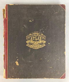
1872 New Combination Atlas of Lee County Illinois BookMatthew Bullock Auctioneers4.7(1.8k)See Sold PriceFeb 24, 2024
1905 20th Century Atlas of Boone County IllinoisMatthew Bullock Auctioneers4.7(1.8k)See Sold PriceFeb 24, 2024
Book: A Concise Historical, Biographical & Genealogical Atlas of the Principal Events in theClaydon Auctioneers Ltd4.3(125)See Sold PriceFeb 26, 2024
1822 MAP of LEEWARD ISLANDS GEOGRAPHICAL STATISTICAL HISTORICAL antique 17.5x22"Jasper524.5(9.8k)See Sold PriceFeb 27, 2024
1822 MAP of SOUTH AMERICA GEOGRAPHICAL STATISTICAL HISTORICAL antique 17.5x 22"Jasper524.5(9.8k)See Sold PriceFeb 27, 2024
1822 MAP of NORTH & SOUTH AMERICA GEOGRAPHICAL STATISTICAL HISTORICAL antiqueJasper524.5(9.8k)See Sold PriceFeb 27, 2024
1822 MAP of CHILI GEOGRAPHICAL STATISTICAL HISTORICAL antique 17.5x 22" CHILEJasper524.5(9.8k)See Sold PriceFeb 27, 2024
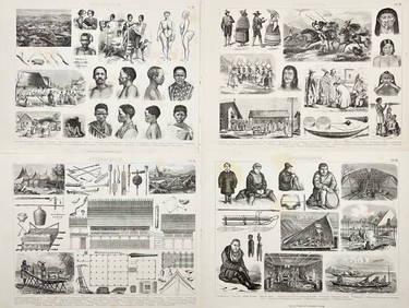
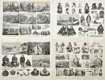
Friedrich Arnold Brockhaus - Set of 4 Prints - Anthropologic Lithography - Sudan - Sennar - Africa -Proverde Auctions4.3(3)See Sold PriceFeb 28, 2024
Friedrich Arnold Brockhaus - Set of 4 Prints - Anthropologic Lithography - Ethnography - Africa -Proverde Auctions4.3(3)See Sold PriceFeb 28, 2024
Robert H Labberton - Map of The Territory of the Present United States - The territory of theProverde Auctions4.3(3)See Sold PriceFeb 28, 2024
Framed Alan King Photo Of Stourhead WiltshireRapid Estate Liquidators and Auction Gallery4.5(1.1k)See Sold PriceFeb 28, 2024


![[BLACK PANTHER PARTY]. Black is Beautiful poster. [With:] Photographic essays, incl. The Vanguard (1 of 8)](https://p1.liveauctioneers.com/197/319238/171467899_1_x.jpg?height=282&quality=70&version=1707520367)


![[New Historical Atlas of Fayette County], 1875 (1 of 1)](https://p1.liveauctioneers.com/179/10971/2682693_1_x.jpg?height=282&quality=70&version=1162265652)