SoldBritish Isles.- - A mixed group of British topograincluding a view of Snowdon by De Loutherbourg and other views of Wales, views of London, Warwickshire and elsewhere in England, and several of Scotland, engravings and lithographs, some with hand-coSee Sold Price
SoldBritish Isles.- Mixed group of mapsMixed group of maps of the British Isles,comprising c.65 sectional maps from Cary's New Map of England and Wales, 4to,1794, and c.130 strip road map sheets, most with maps printed both sides,See Sold Price
SoldBritish Isles.- Mixed group of mapsMixed group of maps of the British Isles,including several of the Ports and Harbours of the Coast of England, by Fullarton, the Channel Isles by Rapkin, county maps by Moule, Cary, and othersSee Sold Price
SoldBritish Isles.- a mixed group of mapsBritish Isles.- a mixed group of maps,including the Isle of Wight, the Isle of Man, 13 Bowen road maps, and with a group of county maps, including Dorset, Devon, Cornwall, Warwickshre, and othSee Sold Price
SoldA Mixed Group Of Loose British Isles MapsA Mixed Group Of Loose Maps Of The British Isles, including 9 Emanuel Bowen county maps of Lancashire, Herefordshire, Bedford, Hartfordshire, Shropshire, Cambridgshire and others, engraved mSee Sold Price
SoldMaps British A small, mixed group of mapsBritish Isles.- A small, mixed group of maps,including Scotland, Essex, Glocester & Monmouth, Nottinghamshire, and others, six engraved maps, and one chart, from 450 x 380 to 380 x 570mm., eacSee Sold Price
Soldgroup of folding British regional mapsBritish Isles.- a small, mixed, group of folding maps,including Great Northern Railway, from Bridlington to Basingstoke, from Wrexham to Great Yarmouth, 1898; Black's Road & Railway TravellingSee Sold Price
SoldBellin (J N) 6 maps of the British IslesBellin (J N) A small, mixed group of maps of the British Isles, including maps of Kingsaill and Galloway, Plymouth, Yarmouth, Huntingdonshire, and northern England, engravings, most with hand-See Sold Price
SoldA Small Group Of Maps Of The British IslesA Small, Mixed Group Of Maps Of The British Isles, including several of Scotland (7), Ireland (5), England and Wales (12), by S.Hall, J. Bartholemew, and others, lithographs and engravings, vSee Sold Price
SoldA mixed group of maps of the British IslesA large mixed group of maps of the British Isles, including several county maps, small road maps (10), and others of England, Wales, Scotland and Ireland, engravings and lithographs, severalSee Sold Price
SoldBritish topography.- A large mixed group of prints ofNO RESERVE British topography.- A large mixed group of prints of the British Isles, approximately 150, including Robert Sayer's 'A prospect of Stone-Henge From the west', a single landscape vignette oSee Sold Price
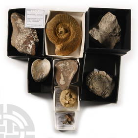
SoldBritish Fossil and Tool CollectionJurassic Period, 199-145 million years BP and later. A mixed group comprising: a fossil red deer tibia from Mesolithic deposits, Bouldnor Cliff, Isle of Wight; a Neolithic scraper found Great LangdaleSee Sold Price
SoldNatural History - British Fossil CollectionLower Cretaceous Period, 120 million years BP and later. A mixed group of fossils, most in card cases, comprising: an iguanodon vertebra from Brook Bay, Isle of Wight; an aurochs astragalus from BouldSee Sold Price
SoldA mixed group of county mapsBritish Isles.- A mixed group of county maps, Worcestershire, Devonshire, Westmoreland, Shropshire, Derbyshire, Middlesex, Northumberland, Durham, Glocestershire, Shropshire, for or by W.Kip,See Sold Price
SoldA small, mixed group of mapsA small, mixed group of British Isles maps, including Barkshire, Buckinghamshire, Brittania Romana, and others, by various authors, including J. Speed, H. Moll, and others, engravings, v.s. fSee Sold Price
SoldA small, mixed group of mapsBritish Isles.- A small, mixed group of maps, of Europe, the Middle East, India, Russia, Brazil and the world, engravings, from 180 x 110 to 200 x 510mm., various conditions, mostly 19th centuSee Sold Price
SoldA small, mixed group of national maps and town plBritish Isles.- A small, mixed group of national maps and town plans, including plans of New York, Brussels, Liverpool, Odessa and others, mostly European, engraved and lithographic maps, someSee Sold Price
SoldA small, mixed group of maps and town plans of EnBritish Isles.- A small, mixed group of maps and town plans of England and Scotland, including several of Kent and the Isle of Thannet, the Isle of White, road maps and town plans, including TSee Sold Price
Sold12 Pc, Mixed Group "British 19th C. Naval" SoldierEnglish, 20th century. A twelve piece mixedgrouping of British 19th century naval toysoldiers including Ducal, Marlborough andBlenheim. Marked accordingly to underside. Approx:h. 2.25" Provenance: FroSee Sold Price
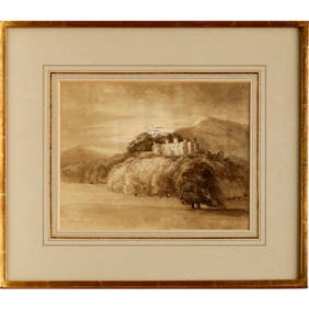
SoldA mixed group of British viewsBritish Topography.- A mixed group of British views,including Oxford, Henley, Marlow, Reading and Newbury, by or after J. Walker, E. Dayes, J. Newton, T. Girtin, W. Stukeley, W. B. Cooke, S. OSee Sold Price
SoldWorld India - Alwar and British India Mixed Group [6]Group of mixed India coins comprising: Alwar rupee (1882); British India quarter rupee (1918), 8 annas (Bombay mint, 1919), 4 annas (Calcutta mint, 1920) and 1/12 anna (1909 and 1917). 30.93 grams totSee Sold Price
SoldA Mixed Group of British & Continental DiecastBritish & Continental diecast group - Lone Star Tanker, metallic blue cab, red Tanker "Rocket Fuel" Crescent Saloon Car, Micro Models, Semi Trailer, yellow cab, red back, another red cab, Transport TrSee Sold Price
SoldA Mixed Group of British DiecastVarious British diecast group - Husky No.20 Ford Thames Van, red, 2002 Car Transporter, Corgi Qualitoys No.706 Giraffe Transporter, TP No.9 Sports Car (overall pitting to upper surfaces, Good) and othSee Sold Price
SoldWorld India - Alwar and British India Mixed Group [6]Group of mixed India coins comprising: Alwar rupee (1882); British India quarter rupee (1918), 8 annas (Bombay mint, 1919), 4 annas (Calcutta mint, 1920) and 1/12 anna (1909 and 1917). KM# 45/518/520/See Sold Price
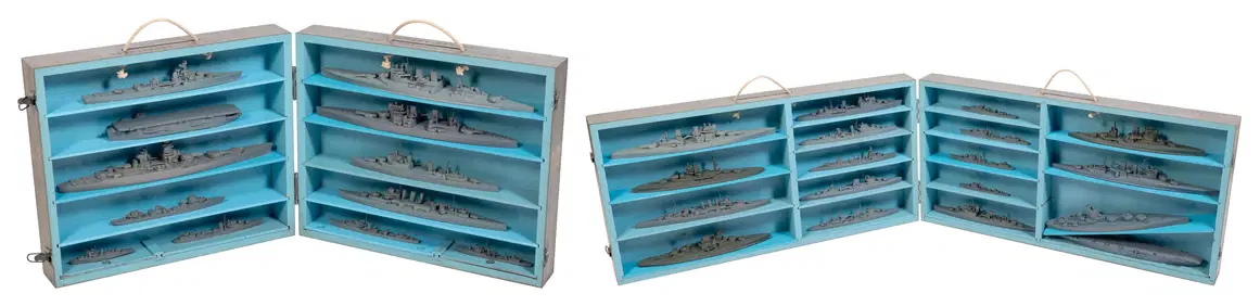
TWO CASED SETS OF WORLD WAR II-ERA U.S. NAVY RECOGNITION/TEACHING MODELS OF BRITISH AND FRENCH SHIPSEldred's4.7(418)See Sold PriceFeb 27, 2024
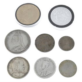
World Coins - British Empire - Mixed Pennies Group [6]TimeLine Auctions Ltd.4.6(182)See Sold PriceMar 09, 2024
ATTR TO LIBERTY COMPANY ARTS CRAFTS COPPER MIRRORAntique Arena Inc.4.5(866)See Sold PriceFeb 24, 2024
ARTS AND CRAFTS HAMMERED LAMP BY FREDRICK FIFIELDAntique Arena Inc.4.5(866)See Sold PriceFeb 24, 2024
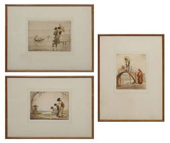
Robert Herdman-Smith (British, 1879-1945), Group of Three Geishas Color Etchings, consisting of:Crescent City Auction Gallery4.3(231)See Sold PriceMar 01, 2024
AN ANTIQUE FOLDING MAP OF THE BRITISH ISLES DATED 1873Hutchinson Scott Auctioneers4.4(42)See Sold PriceFeb 28, 2024
17PC 1965-66 British Rave Pop Music Magazine GroupBruneau & Co. Auctioneers4.5(491)See Sold PriceFeb 24, 2024
Map: A 17thC engraved map of the British Isles titled A Generall Mapp of the Isles of GreatClaydon Auctioneers Ltd4.3(125)See Sold PriceFeb 26, 2024
VARIOUS ARTISTS [BRITISH TRAVEL GUIDES]. Group of 6 map booklets and flyers. 1930s.Swann Auction Galleries4.4(69)See Sold PriceFeb 29, 2024
Jeffrey Steele (Welsh British, 1931-2021) Modern Mixed Media Optical ArtAkiba Galleries4.7(1.8k)See Sold PriceFeb 29, 2024
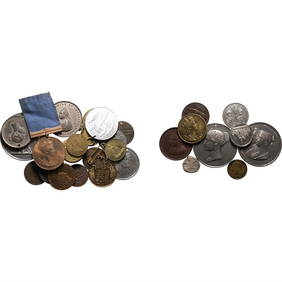
Large Group of Mixed Dates UK and Territories Coinage Australia New Zealand Hong KongGCB Estate Sales4.5(86)See Sold PriceMar 02, 2024
Group of 10 Lower Canada, British Colonial. Duke of Wellington CU Tokens.Fellows4.3(159)See Sold PriceFeb 29, 2024
British Mini Medal Group, Pip Squeak & WilfredRapid Estate Liquidators and Auction Gallery4.5(1.1k)See Sold PriceFeb 29, 2024


![World India - Alwar and British India Mixed Group [6] (1 of 1)](https://p1.liveauctioneers.com/1191/34736/14249654_1_x.jpg?height=282&quality=70&version=1352845864)


![World Coins - British Empire - Mixed Pennies Group [6] (1 of 1)](https://p1.liveauctioneers.com/1191/317894/170617541_1_x.jpg?height=282&quality=70&version=1706620797)


![VARIOUS ARTISTS [BRITISH TRAVEL GUIDES]. Group of 6 map booklets and flyers. 1930s. (1 of 2)](https://p1.liveauctioneers.com/199/319703/171640571_1_x.jpg?height=282&quality=70&version=1707943705)


![World India - Alwar and British India Mixed Group [6] (1 of 1)](https://p1.liveauctioneers.com/1191/43910/19364282_1_x.jpg?height=282&quality=70&version=1376056451)