Sold7 Maps incl: La Jamaique aux Anglois... 1746.[Bermuda/Antigua]. 7 Maps. ++ Le Bermude, Dedicate All'Illusstrissimo Sig:r Abbate Isidoro Bernardi. From a sheet containing other maps. From P. Coronelli's "Corso Geographico Universale," [Venice: caSee Sold Price
SoldLa Jamaique.../ La Bermude... 1767.[Caribbean/Bermuda/Jamaica]. 1 Sheet bearing 2 maps: La Jamaique aux Anglois dans le Golfe du Mexique/ La Bermude aux Anglois. Paris: Crepy, 1767. Plate number “87.” in margin at upper right. FromSee Sold Price
Crepy: La Jamaique and La Bermude, 1767Map Title: La Jamaique aux Anglois dans le Golfe du Mexique (and) La Bermude aux Anglois Publisher: Jean Baptiste Crepy Printed in Paris Publishing Date: 1767 Dimensions: 12.5 x 9.5 inches Please noteSee Sold Price
Buache: Carte de l'isle de la Jamaique aux Anglois 1740Map: Carte de l'isle de la Jamaique aux Anglois Cartographer: Buache Place & Date: Paris / 1740 Size: 12 3/8" x 9 1/4" A beautifully designed and well preserved map of Jamaica with many place names (eSee Sold Price
Buache: Antique Map of English Jamaica, 1740Map: Carte de l'isle de la Jamaique aux Anglois Cartographer: Buache Place & Date: Paris / 1740 Size: 12 3/8" x 9 1/4" Condition: wash color; overall age-toning; minor fraying along edges of wide margSee Sold Price
Sold3 Maps incl: Plan de la Bay et Rade... 1781.[Bermuda/Nautical Maps]. 3 Engraved Maps. ++ Plan de la Baye et Rade du Cap Francais… Shows soundings. Inset: “S. Domingue.” De Foligne, 1781. 14 7/8” x 15 ¾”. Mat burn. Tape to edges of veSee Sold Price
SoldJacques Nicolas Bellin (French, 1703-1772) MapsJacques Nicolas Bellin (French, 1703-1772), two small maps incl., "Carte de la Floride, de la Louisiane, et Pays Voisins", 1757, 8 5/8 in. x 11 7/8 in.; "Plan de la Nouvelle Orleans", 1764, 8 1/8 in.See Sold Price
Sold8 Maps incl: Carte Particuliere de la Moravie.[Europe/New England/Carribean]. 8 Maps. Smallest: 6 7/8” x 9”. Largest:19 ¾” x 25 ¼”. Maps. 3 are matted (margins not examined). Versos not examined. First 5 have hand-colored outline. ++ CaSee Sold Price
SoldHistoire de la Jamaique, Traduite de l'Anglois...Histoire de la Jamaique, Traduite de l'Anglois. Par M. *** [Joseph Raulin], ancient Officer de Dragons.. SLOANE, Sir Hans (1600-1753). London: Nourse, 1751. 2 volumes. 12mo (6 4/8 x 3 5/8 inches). 6 eSee Sold Price
MAP, St. Kitts & Barbados, Le RougeSt. Kitts & Barbados. Le Rouge, Isle St. Christophle une des Antilles aux Anglois [on sheet with] La Barbade une des Antilles aux Anglois Divisee par Paroises, from Atlas Nouvea Portatif..., 1748 (cirSee Sold Price
SoldTachard.Voyage de Siam,2v,1686-9Tachard (Guy) Voyage de Siam, des peres Jesuites, envoyez par le Roy aux Indes & à la Chine...,title with engraved device, engraved head-pieces & initials and 7 plates and maps only (of 20), ASee Sold Price
SoldCarte Qui Contient U*ne Description... [1719].[Caribbean/US East Coast]. Carte Qui Contient Une Description Des Iles & Terres Que Les Anglois Possedent Dans L’Amerique Septentrionale, Et En Particulier De La Jamaique. 1 Sheet, consisting of 7 mSee Sold Price
Sold3 Maps/Engravings incl: CARTE DE LA VIRGINIE...[North America/US/France] 3 Engravings. ++ CARTE DE LA VIRGINIE, DE LA BAYE CHESAPEACK, et Pays Voisins. Pour server a l’Histoire Generale des Voyages… Folding map. [Bellin. C. 1760s-1770s]. 7 ½�See Sold Price
SoldUSA 1903 Lot of 7 State Maps. FL, SC, KY, TN, MS, AR LAIncl Florida, South Carolina, Kentucky, Tennessee, Mississippi, Arkansas, and Louisiana. Lithograph Maps Published 1903 by Adam & Charles Black, Edinburgh & London for "Encyclopaedia Brittannica" TentSee Sold Price
Defence of St-Laurent-du-Var by Gen Suchet 1800. Nice,TITLE/CONTENT OF MAP: 'Plan de la Défense du Pont du Var par le Corps d'Armée aux ordres du Lieutenant général Suchet' DATE PRINTED: 1819 IMAGE SIZE: Approx 15.0 x 20.0cm, 5.75 x 7.75 inches (MediSee Sold Price
SoldSet of Louis Philippe Panel Cut Glass GobletsSet of Louis Philippe Panel Cut Glass Goblets, 19th c., incl. 8 water, h. 5 7/8 in.; 8 white wine, h. 4 5/8 in.; and 8 sherry, h. 4 1/4 in. (24 pcs.). Provenance: Aux Vieux Paris, Breaux Bridge, LA; TSee Sold Price
Bellin, Jacques Nicolas. Plan de la Baye de ChibouctouBellin, Jacques Nicolas Plan de la Baye de Chibouctou nommee par les Anglois Halifax 1763 Copperplate engraving; original coloured Printed size: 34.8 x 21.9 cm; 13.7 x 8.6 in This handsome copper engrSee Sold Price
Soldvan der Aa: Antique Map of Southeast US, 1713Map: La Floride Suivant les Nouvelles Observations de Messrs. de l'Academie Royale des Sciences (eastern seaboard to New Mexico) Cartographer: van der Aa Place & Date: Leiden / 1713 Size: 14 7/8" x 10See Sold Price
SoldLOT (3) EARLY POCKET BOOK MAPS C.1830'sLOT (3) EARLY POCKET BOOK MAPS INCL. H/C STATE OF NEW YORK BY HUMPHREY PHELPS,1833, 16" X 21", STATE OF NEW JERSEY BY J. LOW, C. 1830, 10 1/2" X 7 1/2", STATE OF PENNSYLVANIA BY A. FINLEY, C. 1830, 9"See Sold Price
SoldMarie Laurencin, Signed, La Dame Aux Carmillas with COAMarie Laurencin, Signed, La Dame Aux Carmillas with COA. Signed in plate dated 1936; Color lithograph, Pencil signed. Framed. Has COA attached on verso. Size: 7.5 x 6 image, outside of frame: 20 x 18.See Sold Price
de la Tour: Antique Map of World in Hemispheres, 1771Mappe-Monde, dressée pour l'etude de la Géographie, rélativement aux auteurs les plus modernes. Revûë, corrigée et augmentée d'apres les Nouvelles Observations Astronomiques de Mrs. TchirikcowSee Sold Price
SoldBellin: Antique Map of Chesapeake Bay, 1757Map: Carte de la Baye de Chesapeack et Pays Voisins Cartographer: Bellin Place & Date: Paris / 1757/1760 Size: 11 1/8" x 7 3/8" Condition: b&w; overall age toning; some minor spotting; a tiny repairedSee Sold Price
SoldBellin: Antique Map of the Carolinas and Georgia, 1757Map: Carte de la Caroline et Georgie Cartographer: Bellin Place & Date: Paris / 1757/1760 Size: 11 1/8" x 7 3/8" Condition: b&w; overall age toning; some spotting and staining; a tiny repaired puncturSee Sold Price
Ottens: Antique Magellanica Map of Rio de la Plata 1745Map: Tractus australior Americae meridionalis Cartographer: Reiner & Joshua Ottens Place & Date: Amsterdam / 1745 Size: 21 1/2" x 18 7/8" Condition: Beautiful original color; overall age toning; brownSee Sold Price
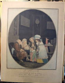
Philibert-Louis Debucourt Original Engraving Le Compliment 1787 VERY RARE!Luis Porretta Fine Arts4.3(10)See Sold PriceMar 02, 2024
Vaillant - Hawaii: Stranding in the Sandwich Islands (Echouage aux Iles Sandwich). 43Trillium Antique Prints & Rare Books4.5(30)See Sold PriceFeb 24, 2024
Vaillant - Hawaiian Dance (Scene de Danse aux Iles Sandwich). 42Trillium Antique Prints & Rare Books4.5(30)See Sold PriceFeb 24, 2024
Filomarino - Mount Vesuvius Volcano Erupting. 7Trillium Antique Prints & Rare Books4.5(30)See Sold PriceFeb 24, 2024
JAMES ABBOTT MCNEILL WHISTLER (1834-1903) "LA VIELLE AUX LOGUES".Amelia Jeffers, Auctioneers & Appraisers4.5(116)See Sold PriceMar 07, 2024
STAR TREK: THE NEXT GENERATION (1987-1994) - Caldos Colony Weather Control TransparencyPropstore4.2(6)See Sold PriceMar 14, 2024
Kees Van Dongen - Comme dans Louise, les couples, du haut de la Butte, contemplaient Paris, 1949NCAG4.4(32)See Sold PriceMar 10, 2024
1764 Bellin Map of Eastern Guadeloupe in the Lesser Antilles -- Partie Orientale de l'Isle de laJasper524.5(9.8k)See Sold PriceFeb 27, 2024
1764 Bellin Map of St. Kitts -- Carte de l'Isle St. ChristopheJasper524.5(9.8k)See Sold PriceFeb 27, 2024
1764 Bellin Map of Southern Portion of Martinique -- Partie Meridionale de la MartiniqueJasper524.5(9.8k)See Sold PriceFeb 27, 2024
Frigate Tropicbird Flying fish Albacore Bonito Dorado Tuna Waterspout 1746Jasper524.5(9.8k)See Sold PriceFeb 28, 2024
Jules Verne, De La Terre a La Lune, Au Steamer Red MacaronLion and Unicorn4.8(1.9k)See Sold PriceMar 10, 2024
Antique Pennsylvania Map Fragment incl Wellersburg and New CentervilleCordier Auctions4.4(1.5k)See Sold PriceMar 02, 2024


![Carte Qui Contient U*ne Description... [1719]. (1 of 8)](https://p1.liveauctioneers.com/179/49347/23134453_1_x.jpg?height=282&quality=70&version=1388699156)