SoldNova Anglia, Novum Belgium Et Virginia...[East Coast]. Nova Anglia, Novum Belgium Et Virginia. East Coast from Nova Scotia to what is now North Carolina, with a wide Delmarva Peninsula. Inset of Bermuda. Probably engraved by Hessel Gerritsz.See Sold Price
SoldJansson - Nova Anglia, Novum Belgium et VirginiaJan Jansson (1588-1664), Nova Anglia, Novum Belgium, et Virginia, 1636, black and white line engraving with period color, 15-1/4 X 19-3/8 in. (plate), 19-1/2 x 23 in. (overall); unframedNotes: ThisSee Sold Price
SoldNova Anglia, Novum Belgium et VirginiaJoannes Janssonius (after Johannes de Laet). Engraved map with original hand color in outline. Amsterdam, c. 1630. 19 5/8 x 24 inches, 29 1/8 x 33 3/8 inches framed. Extremely influential map of the eSee Sold Price
SoldJan Jansson Map, Nova Anglia Nova Belgium et Virginiauncolored copperplate engraving, Amsterdam, second quarter of the 17th century, from the Theatre du Monde ou Nouvel Atlas showing North America's Atlantic coast from Nova Scotia south to North CarolinSee Sold Price
SoldJan Janssonius (1588-1664, Dutch), Nova Anglia NovumJan Janssonius (1588-1664, Dutch), Nova Anglia Novum Belgium et Virginia," 1740, hand colored, H.- 18 3/4 in., W.- 22 1/4 in.See Sold Price
SoldJansonius Map of North.East. U.S., 1636.JANSSONIUS, Johannes (1588-1664). Nova Anglia Novum Belgium et Virginia. Engraving with original hand color in part. Amsterdam, 1636 or later. 18 1/2" x 22".See Sold Price
SoldJohannes Janssonius engraved map of Nova AngliaJohannes Janssonius engraved map of Nova Anglia Novum Belgium et Virginia, Amersterdam 1639-42, 15 1/2'' x 20''.See Sold Price
SoldJohannes Janssonius, double page hand coloredJohannes Janssonius, double page hand colored engraving, Nova Anglia Novum Belgium et Virginia, sight size 15 1/2" x 20"See Sold Price
SoldInfluential map of northeastern America 1636Heading: Author: Jansson, Jan Title: Nova Anglia Novum Belgium et Virginia Place Published: Amsterdam Publisher: Date Published: 1636-[1639] Description: Engraved map, uncoSee Sold Price
SoldJanssonius Map of East coastJANSSONIUS, Joannes. Nova Anglia Novum Belgium et Virginia. Copperplate engraving. Amsterdam, 1636 (first State). Burden 247. 18 3/4 x 22 1/2 inches sheetSee Sold Price
Sold17th Century Map of the Eastern UnitedStates [Nova Anglia, Novum Belgium et Virginia,] by Jan Jansson, originally published 1636, Amsterdam, showing the Dutch and English holdings in the United States, early place names for Manhattan (ManSee Sold Price
SoldJANSSONIUS, JOANNES. Nova Anglia, Novum BelgiuJANSSONIUS, JOANNES. Nova Anglia, Novum Belgium et Virginia. Double-page engraved map, 395x510 mm, wide margins, Dutch text on verso; repair in lower margin on recto; matted. McCorkle 636.2. AmsterdamSee Sold Price
Sold17th Century Map of EasternUnited States [Nova Anglia, Novum Belgium et Virginia], by Jan. Jansson, originally published 1636, Amsterdam, showing the Dutch and English holdings in the United States, early place names for ManhatSee Sold Price
SoldJANSSONIUS, JOANNES. Nova Anglia Novum Belgium etJANSSONIUS, JOANNES. Nova Anglia Novum Belgium et Virginia. Double-page engraved map of the northeast American coast. 19¾x23¼ inches sheet size, wide margins; original hand-color in outline;See Sold Price
SoldJansonius Nova Anglia rare mapJanssonius, Joannes (after Johannes de Laet) Nova Anglia, Novum Belgium et Virginia. Engraved map with origianl hand color in outline. Amsterdam, c. 1630. 19 5/8" x 24" sheet, 29 1/8" x 33 3/8" framedSee Sold Price
SoldJanssonius Map of American ColoniesJANSSONIUS, Johannes (1588-1664). Nova Anglia Novum Belgium et Virginia. Engraved map with original hand color. Amsterdam, 1637 (First State, English Text). 19 1/2 x 23 1/4 inches sheet, 31 x 34 incheSee Sold Price
SoldJansonius Map of N.E. U.S., 1636JANSSONIUS, Johannes (1588-1664). Nova Anglia Novum Belgium et Virginia. Engraving with original hand color in part. Amsterdam, 1636 or later (First State). 19" x 22" sheet, 24" x 28" framed. First stSee Sold Price
Jansson Map of New England and VirginiaJANSSON, Jan (1588-1664). Nova Anglia, Novum Belgium et Virginia. Engraving with original hand color. From Geradi Mercatoris et I. Hondii Atlas.Amsterdam, c. 1636 (English Text). 24 1/2" x 18" sheet,See Sold Price
Dutch Hand-Colored Map of New England, c. 1640Nova Anglia, Novum Belgium et Virginia, Amsterdam ca. 1636-42. Hand-colored copper-plate engraving with Dutch text front and back. The outline color of the map and full color of the elegant title cartSee Sold Price
SoldJansson Northeast U.S. MapJansson, Jan (1588-1664). Nova Anglia Novum Belgium et Virginia. Engraved map with original hand color. Amsterdam, c. 1636. 17 3/4” x 22” sheet. This is the first state of Jansson's important mapSee Sold Price
Jansson Northeast U.S. MapJansson, Jan (1588-1664). Nova Anglia Novum Belgium et Virginia. Engraved map with original hand color. Amsterdam, c. 1636. 18 1/4" x 22 1/4" sheet, 24" x 28" framed. This is the first state of JanssoSee Sold Price
Janssonius Map of Nova AngliaJANSSONIUS, Joannes (1588-166), after DE LAET, Johannes (1581-1659). Nova Anglia, Novum Belgium et Virginia. Engraved map with orginal hand color in outline. Amsterdam, c. 1630. 19 5/8" x 24" sheet, 2See Sold Price
SoldJansson Nova Anglia MapNova Anglia Novum Belgium et Virginia. Jan Jansson (1588-1664). Amsterdam, 1636. Engraved map with hand color in part. 16 1/4 x 20 3/4 inches visible, 25 1/2 x 30 inches framed. This is the first statSee Sold Price
SoldDutch Hand-Colored Map of New England, c. 1640Nova Anglia, Novum Belgium et Virginia, Amsterdam ca. 1636-42. Hand-colored copper-plate engraving with Dutch text front and back. The outline color of the map and full color of the elegant title cartSee Sold Price
WILLEM JANSZOON BLAEU (NETHERLANDS, 1571-1638)Thomaston Place Auction Galleries4.4(386)See Sold PriceFeb 24, 2024
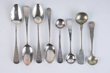
GROUPING OF STERLING & COIN SILVER SPOONSJohn McInnis Auctioneers,LLC4.6(502)See Sold PriceFeb 24, 2024
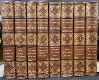
SAINTE BIBLE CONTENANT L’ANCIEN ET LE NOUVEAU TESTAMENT, PAR LE R.P. DE CARRIERES, 8 VOLUMES, 1862The Rug Life4.3(12)See Sold PriceMar 07, 2024
De Jode, Rare, pub. 1593 - Map of Italy (Italiae Totius Orbis olim Domatricis Nova ExactissTrillium Antique Prints & Rare Books4.5(30)See Sold PriceFeb 24, 2024
Map: A 17thC engraved and hand coloured map after Frederik de Wit (1630-1706) titled Nova Persiae,Claydon Auctioneers Ltd4.3(125)See Sold PriceFeb 26, 2024
1660 Valerius Maximus Cum Selectis Observati ANTIQUE VELLUM BINDINGJasper524.5(9.8k)See Sold PriceFeb 27, 2024
1499 INCUNABULA FOLIO antique Sacred letters of St.Paul interpretation INCUNABLEJasper524.5(9.8k)See Sold PriceFeb 27, 2024
Van Houtte (Pub) C1860 Pair of Folio Greenhouse Prints. BelgiumAlbion Auctions4.6(336)See Sold PriceMar 07, 2024
1660 ANTIQUE VELLUM BINDING VALERIUS MAXIMUS CUM SELECTIS OBSERVATINY Elizabeth 4.3(84)See Sold PriceMar 03, 2024
Copper Creek Wall Graphic by Nova JBRapid Estate Liquidators and Auction Gallery4.5(1.1k)See Sold PriceMar 01, 2024