SoldGROUP OF THREE FOTOCROMIA MAPS.GROUP OF THREE FOTOCROMIA MAPS. Printed in Florence, Italy. Depicting Italy, Europe, and the Americas. Together with a wood carving of an old man smoking a pipe, signed "Lesfin '86" and a group of fifSee Sold Price
SoldA Group of Three Maps, Largest 19 x 22 1/4 inchesA Group of Three Maps, each handcolored, unframed. Largest 19 x 22 1/4 inches.See Sold Price
SoldGroup of three maps to include framed Magna BritanniaGroup of three maps to include framed Magna Britannia Complectens Angliae scotiae......Bapt. Homann and two unframed, Hampshire unframed map, regulated by Astron observations by T Kitchin, improved maSee Sold Price
Sold(HAWAII) A group of three maps of Hawaii, 1878.(HAWAII) A group of three maps of Hawaii and the Pacific region. Kauai. Government Survey. 1878. Washington: The Morris Peters Co., n.d. The Pacific Ocean, including Oceana. Thomas Cowperthwait,See Sold Price
SoldGroup of Three Maps by Nicolas Sanson (1600-1667,Group of Three Maps by Nicolas Sanson (1600-1667, Paris), "La Gaule en dixsept provinces Romain," 1641; together with "Gouvernment General du Lyonnois, Forez, Beavoilais," 1679; and "Gouvernment De FrSee Sold Price
SoldGroup of Three Maps by Antonio Zatta (1757-1797,Group of Three Maps by Antonio Zatta (1757-1797, Venice), consisting of "L'Esremadura a la Castiglia Nuova," 1776; "Andalusia e Granada," 1776; and "La Catalogna Li Regni Di Aragona ed Alta Navarra,"See Sold Price
A Group of Three Maps by John Gibson, 18th Century,A Group of Three Maps by John Gibson, 18th Century, Including 'A Map of 100 Miles Round Boston', 'A Map of the Icy Sea in with the Land Waters and Others', and 'The British Government in North AmericaSee Sold Price
SoldGroup of Three MapsGroup of Three Maps Three engraved maps with hand-coloring including: La Principaute D'Orange; Carte Geometrique des Environs de l'Etang de Long; and Mer Oceane. All approximately 18 x 22 1/2 in. (sheSee Sold Price
SoldGroup of Three MapsCollection of three maps, to include one 20th century reprint of a 17th century celestial map, one map of Chesapeake Bay, and one large map of New England, 45" high x 64" wide (frame, largest). ProvenSee Sold Price
SoldGroup of Three Maps by Antonio Zatta (1757-1797,Group of Three Maps by Antonio Zatta (1757-1797, Venice), consisting of "Li Regni, di Valenza, e Murcia," 1775; "Li Regni Galizia, Asturies, Leon, Castiglia Vecchia," 1776; and "Li Circon D'Austria eSee Sold Price
Group of Three Maps, consisting of "Hawaii," 1905, byGroup of Three Maps, consisting of "Hawaii," 1905, by Rand McNally, matted and shrink wrapped; "Louisiana," by J. H. Colton, 1855, hand colored, matted and shrink wrapped; and "United States SouthernSee Sold Price
Group of three maps to include framed Magna BritanniaGroup of three maps to include framed Magna Britannia Complectens Angliae scotiae......Bapt. Homann and two unframed, Hampshire unframed map, regulated by Astron observations by T Kitchin, improved maSee Sold Price
SoldGroup of Three Maps by Antonio Zatta (1757-1797,Group of Three Maps by Antonio Zatta (1757-1797, Venice), "L'America divisa ne' suoi Principali Stati," 1776; "Regni d'Aracan del Pegu di Siamdi Cambogue e di Laos," 1785; and "America Meridionale DivSee Sold Price
SoldGroup of Three Maps by Antonio Zatta (1757-1797,Group of Three Maps by Antonio Zatta (1757-1797, Venice), "Parte de Regno D'lrlanda le Provincie D'Ulster e Leinster," 1778; "Parte del Regno D'lrtanda D'Connaught e Munster," 1778; and "La Scozia SepSee Sold Price
SoldGroup of Three Maps by Antonio Zatta (1757-1797,Group of Three Maps by Antonio Zatta (1757-1797, Venice), consisting of "II Regno di Scozia," 1776; "Carte Septentrinale lnghilterra Principato ai Galles," 1778; and "Carte Meridionale Galles," 1778,See Sold Price
SoldGroup of Three Maps, consiting of Jules RenouardGroup of Three Maps, consiting of Jules Renouard (1798-1844, Paris)," Etats-Unis," 1826, hand colored, H. - 8 1/4 in., W. - 16 1/2 in.; Unknown, "A Map of the Vicounty of Paris. Drawn from a great numSee Sold Price
SoldGrp: 3 Maps Eastern Europe Ukraine Romania BlaeuGroup of three maps of Eastern Europe. Includes one map of Walachia, Serbia, Bulgaria, and Romania by Willem Janszoon Blaeu (1571-1638); one map of Slovenia, Croatia, and Bosnia by Blaeu after GerarduSee Sold Price
SoldGrp: 3 Maps of New York CityGroup of three maps of New York City. Includes Mark Tiddeman, "A Draught of New York from the Hook to New York Town," London: W. Mount & T. Page; "Map of New York and the Adjacent Cities," New York: JSee Sold Price
Sold(MAP) BLAEU, JOHANNES. Three maps of Asian provinces(MAP) BLAEU, JOHANNES A group of three maps of Asian provinces from Blaeu's Atlas Sinensis, (Amsterdam, 1655), comprising Xansi, Imperii Sinarum Provincia Secunda; Xensi, Imperii Sinarum Provincia TeSee Sold Price
Sold3PC C.1907 Providence Telephone Company RI MapsUnited States,Circa 1907 Group includes three maps covering the roads and telephone lines of Rhode Island. 28 1/2 x 35 1/2",Paper, woodSee Sold Price
SoldGrp: 3 Maps of the Caribbean and BarbadosGroup of three maps of the Caribbean. Includes two maps of the overall region, one by Nicolaes Visscher, which depict the Gulf Coast, Florida, the Caribbean, and northern South America. With one map oSee Sold Price
SoldGroup of 3 Maps by Giovanni Battista Ramusio SumaGroup of three maps by Giovanni Battista Ramusio (1485-1557). This group includes two woodcuts of Sumatra from "Delle Navigationi et Viaggi," ca. 1565. The third map is a fine example of Rasmusio's inSee Sold Price
SoldGrp: 3 Maps of EuropeGroup of three maps of Europe. Includes one hand colored map of the Netherlands by Herman Moll (1654-1732), "A New Map of the United Provinces of Netherlands &c." London: Herman Moll, ca. 1701; one DuSee Sold Price
SoldGrp: 3 Maps of the Coast of AfricaGroup of three maps of the west coast of Africa by Guillaume Rouille (ca. 1518–1589): "Carte Reduite des Costes Occidentales d'Afrique," 1753; "Carte Generale de la Coste de Guinee," 1750; andSee Sold Price
Group of Three Palestinian Embroidered Ghudgehs (Veils)Nazmiyal Auctions4.4(34)See Sold PriceFeb 26, 2024
Group of Three Wadhams Mobil Road MapsCheck the Oil Promotions, LLC4.6(275)See Sold PriceFeb 25, 2024
Four White Pass & Yukon Route Playing Card DecksRail & Road Auctions4.6(165)See Sold PriceMar 08, 2024
Group of Three Knives, 19th/20th c., Bowie- L.- Blade- 8 in., Overall- 12 1/4 in.; G.C.- L.- Blade-Crescent City Auction Gallery4.3(229)See Sold PriceMar 01, 2024
[CIVIL WAR]. Group of Three Signed Documents for A Soldier ...Potter & Potter Auctions4.6(539)See Sold PriceMar 07, 2024
LINCOLN, Abraham (1809-1865). Group of Three Later Prints o...Potter & Potter Auctions4.6(539)See Sold PriceMar 07, 2024
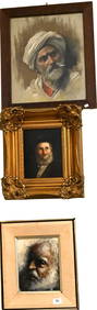
[CLOWNS]. Group of Three Tintype Portraits ...Potter & Potter Auctions4.6(539)See Sold PriceMar 07, 2024
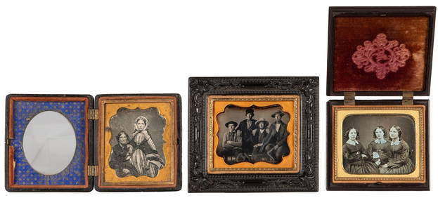
Group of Three One-Sixth Daguerrotype Pictures in Thermopla...Potter & Potter Auctions4.6(539)See Sold PriceMar 07, 2024
[BASEBALL]. Group of Three Pinkerton Tobacco Cards, One Bei...Potter & Potter Auctions4.6(539)See Sold PriceMar 07, 2024
West Indies Islands. Guadaloupe. | Mariegalante &C. | Antigua.Jasper524.5(9.8k)See Sold PriceFeb 27, 2024
Alfred Salzman, Etc. JNF Tin Tzedakah Boxes, 3Auctions at Showplace4.5(726)See Sold PriceApr 07, 2024


![[CIVIL WAR]. Group of Three Signed Documents for A Soldier ... (1 of 3)](https://p1.liveauctioneers.com/928/318880/171360937_1_x.jpg?height=282&quality=70&version=1707501302)

![[CLOWNS]. Group of Three Tintype Portraits ... (1 of 1)](https://p1.liveauctioneers.com/928/318880/171361229_1_x.jpg?height=282&quality=70&version=1707501302)
![[BASEBALL]. Group of Three Pinkerton Tobacco Cards, One Bei... (1 of 2)](https://p1.liveauctioneers.com/928/318880/171361353_1_x.jpg?height=282&quality=70&version=1707501302)