SoldMap. North-West CoastBy J. Barbell, S. Brown, C. Bulfinch, J. Darby, C. Hatch, J. M. Pintard 1787 Matted and shrink wrapped. 21 1/2"W. x 16 1/8"H.See Sold Price
SoldMap. North-West CoastBy J. Barbell, S. Brown, C. Bulfinch, J. Darby, C. Hatch, J. M. Pintard 1787 Matted and shrink wrapped. 21 1/2"W. x 16 1/8"H.See Sold Price
Davidson: Map of Northwest Coast of America, 1868Map: North West Coast of America. Sheet No.3. Ice Bay to Seven Islands... Date: 1868 Authors: U.S. COAST SURVEY, DAVIDSON, G. Publisher: U.S. COAST SURVEY Size: Folio – 28.00 H x 35.75 W Inches CoasSee Sold Price
North West Coast of America. Sheet No.3. Ice Bay toTitle/Content of Map: North West Coast of America. Sheet No.3. Ice Bay to Seven Islands... Date Printed: 1868 Cartographer: DAVIDSON, G. Size: 28X35.75 Coastal outline with soundings. Shows Cook's InlSee Sold Price
Goos: Antique Map of Northwest Coast of Africa, 1666Title/Content of Map: De cust van Barbaria Gualata, Arguyn, en Geneheo, van Capo S Vincente tot Capo Verde Date Printed: 1666 Cartographer: Goos Size: 20.5" x 16.5" Detailed sea chart of the Iberian PSee Sold Price
SoldRare Spanish map of Northwest Coast 1802Heading: Author: Antillon, Isadoro de Title: La America Septentrional desde su extremo Norte hasta 10° de Latitud segun las ultimas observaciones y descubrimientos para el Curso de Geografia... PlacSee Sold Price
SoldBellin map of Northwest coast 1758Title: Carte Reduite des Parties Septentrionales du Globe, Situees Entre l'Asie et l'Amerique Author: Bellin, Jacques Nicolas Description: Copper-engraved map. 21x35 cm. (8½x14").Unusual chart showinSee Sold Price
Meares map of northwest coast c.1790Title: Carte de la Partie Interieur de l'Amerique Septentrionale... Navigation Interieur depuis la Baye d'Hudson jusqua la Cote Nord-Ouest Author: Meares, John Description: Copper-engraved map25x46 cmSee Sold Price
SoldMeares map of northwest coast c.1790Title: Carte de la Partie Interieur de l'Amerique Septentrionale... Navigation Interieur depuis la Baye d'Hudson jusqua la Cote Nord-Ouest Author: Meares, John Description: Copper-engraved map25x46 cmSee Sold Price
North America - West Coast Strait of Georgia Sheet I.Title/Content of Map: North America - West Coast Strait of Georgia Sheet I. Between Vancouver I. & British Columbia Fraser R, to N.E.Pt. of Texada I. Including Howe Sound & Jervis Inlet Cartographer:See Sold Price
North America - West Coast Strait of Georgia Sheet I.Title/Content of Map: North America - West Coast Strait of Georgia Sheet I. Between Vancouver I. & British Columbia Fraser R, to N.E.Pt. of Texada I. Including Howe Sound & Jervis Inlet Date: 1863-02-See Sold Price
Antique Admiralty Finistère sea coast chart, 1900TITLE/CONTENT OF MAP: 'France North West Coast - Raz de Sein to Goulven including Brest and Ushant' DATE PRINTED: Published 1859; Revised to 1900 IMAGE SIZE: Approx 99.5 x 69.0cm, 39.25 x 27 inches (LSee Sold Price
Dudley Map of The Northwest Coast of America, showing San FranciscoDUDLEY, Robert (1573-1649). [San Francisco to British Columbia] Carta particolare dello stretto di Iezo fra l'America e I'Isola Iezo . . . D'America Carta XXXIII. Engraved map. Florence: Francesco OnoSee Sold Price
SoldArabian Peninsula.- India.- Ortelius (Abraham)Arabian Peninsula.- India.- Ortelius (Abraham) Erythraei Sive Rubri Maris Periplus, map covering the north-west coast of Africa, Arabian peninsular, India, and Malaysia, with inset map of MediterraneaSee Sold Price
Côte NO de l'Amérique & côte NE de lAsie. Alaska &TITLE/CONTENT OF MAP: [Cook 3e Voyage] Carte de la côte Nord-Ouest de l'Amérique et de la côte Nord-Est de lAsie // Plan de l'Entrée de Nootka [Cook's 3rd Voyage - Map of the north-west coast of ASee Sold Price
SoldOrtelius (Abraham) Erythraei sive Rubri Maris PeriOrtelius (Abraham) Erythraei sive Rubri Maris Periplus ...,map covering the north-west coast of Africa, Arabian peninsular, India, Malaysia, with inset map of the Mediterranean in the lower paSee Sold Price
Côte NO de l'Amérique & côte NE de lAsie. Alaska &TITLE/CONTENT OF MAP: '[Cook 3e Voyage] Carte de la côte Nord-Ouest de l'Amérique et de la côte Nord-Est de lAsie // Plan de l'Entrée de Nootka [Cook's 3rd Voyage - Map of the north-west coast ofSee Sold Price
Map of Views of the North West Coast of America, 1798Map: Views of the North West Coast of America explored by the Boussole & Astrolabe in 1786 (1st, 2nd and 3rd Sheets) Maker: G Robinson (pub.) / J La Perouse Date: 1798 Origin: London Size: 10.7 x 16.8See Sold Price
Ortelius (Abraham) Fezzae et MarocchiOrtelius (Abraham) Fezzae et Marocchi, Regna Africae celeberrima, engraved map of the north-west African coast, decorative cartouche and ships, with hand-colouring, 390 x 505mm., French text oSee Sold Price
New Zealand Navy nautical sea chart 1969 mapTITLE/CONTENT OF MAP: 'New Zealand North Island - West Coast - Approaches to Paremata ' DATE PRINTED: Surveyed 1965-67; Published 1969 IMAGE SIZE: Approx 72.0 x 54.5cm, 28.25 x 21.5 inches (Large) TYPSee Sold Price
SoldWorld.- A New Map of the World according to the latestWorld.- A New Map of the World according to the latest Observations, engraved twin-hemisphere map showing the north and west coasts of Australia and California as an island, 180 x 290 mm (7 x 11 1/2 iSee Sold Price
Carte Generale de la Cote du Nord-Ouest deCarte Generale de la Cote du Nord-Ouest de L’Amerique, 1787A large map depicting the Pacific Northwest coast of California by Naval Officer and explorer, Jean-Francois de Galaup de la Perouse.See Sold Price
SoldAtkinson's Northwest Coast with map 1878Title: The Northwest Coast, including Oregon, Washington and Idaho, a series of articles upon the N.P.R.R. in its relations to the Basins of the Columbia and of Puget's Sound Author: Atkinson, G. H. DSee Sold Price
SoldAtkinson's Northwest Coast with map 1878Title: The Northwest Coast, including Oregon, Washington and Idaho, a series of articles upon the N.P.R.R. in it relations to the Basins of the Columbia and of Puget's Sound Author: Atkinson, G. H. DeSee Sold Price
Central Railroad of New Jersey Map of Sandy Hook Route-ca. 1903JM Hobby Supply and Railroad Artifact Auctions4.4(126)See Sold PriceFeb 24, 2024
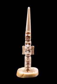
NORTHWEST COAST, 19TH - EARLY 20TH C. TOTEM POLEThomaston Place Auction Galleries4.4(386)See Sold PriceFeb 25, 2024
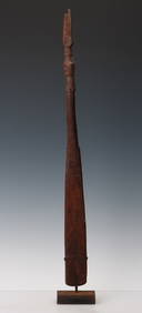
Food Spatula, Geelvink Bay, Northwest Coast Papua New Guinea, Early 20th C. or OlderMaterial Culture4.6(765)See Sold PriceFeb 29, 2024
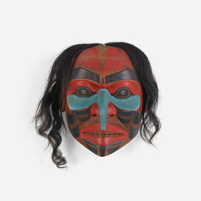
Don Lelooska, Untitled (Northwest Coast mask)Toomey & Co. Auctioneers4.7(390)See Sold PriceFeb 29, 2024
New and Correct Map of North America With the West India Islands,Jasper524.5(9.8k)See Sold PriceFeb 27, 2024
WEST AFRICA. British Cameroons & Togoland mandates. Gold Coast Nigeria 1947 mapJasper524.5(9.8k)See Sold PriceFeb 28, 2024
NORTH & WEST AFRICA. Gold Coast (Ghana) Slave Coast. Tribal names 1890 mapJasper524.5(9.8k)See Sold PriceFeb 28, 2024
Coste Occidentale d’Afrique…' West Africa. Gulf of Guinea. BELLIN 1746 mapJasper524.5(9.8k)See Sold PriceFeb 28, 2024
North & West Africa. Dahomey. Gold Coast. Military Territory. THE TIMES 1922 mapJasper524.5(9.8k)See Sold PriceFeb 28, 2024
FRENCH WEST AFRICA Nigeria Gold Coast Rio de Oro Portuguese Guinea 1912 mapJasper524.5(9.8k)See Sold PriceFeb 28, 2024
Robert de Vaugondy - Map of Canada - Mer de l' Ouest or Sea of the West and a Northwest PassageProverde Auctions4.3(3)See Sold PriceFeb 28, 2024