Map of Jerusalem and the Holy Temple. Pierre Mortier.De Stadt Jerusalm … La ville de Jerusalem. By Pierre Mortier. From: Martin David, Historie des Ouden en Nieuwen Testaments, 1700, vol. 1. Amsterdam, 1700. Plate 97. Between pgs. 192-193. Imaginary mSee Sold Price
SoldMap of Jerusalem – Holy Temple. Amsterdam, 1715Temple de Jerusalem. Holy Temple in Jerusalem and surrounding buildings. Sections of the walls around the city. Nice copperplate. Black and white. By J. Lindenbergh, following Villalpando. Engraved bySee Sold Price
Map of Jerusalem – Holy Temple. Amsterdam, 1715.Temple de Jerusalem. Holy Temple in Jerusalem and surrounding buildings. Sections of the walls around the city. Nice copperplate. Black and white. By J. Lindenbergh, following Villalpando. Engraved bySee Sold Price
SoldIncunabula. Map of Jerusalem. Hartmann Schedel.Imaginary map of walled Jerusalem. The Holy Temple and its environs. Circular city, as generally depicted in the Middle Ages. By Hartmann Schedel. Titled: Hierosolima. Nurnberg, 1493. Incunabula. NiceSee Sold Price
SoldMap of Jerusalem. Hierosolima. By Schedel. Incunabula.Imaginary map of walled Jerusalem. The Holy Temple and its environs. Circular city, as generally depicted in the Middle Ages. By Hartmann Schedel. Titled: Hierosolima. Nurnberg, 1493. Incunabula. NiceSee Sold Price
Sold[Map] Map of the Holy Land.[Map] Map of the Holy Land. Amsterdam: Pierre Mortier, early eighteenth century. Copper engraving. Framed. Matted area 11 ½ x 14". Heavy losses and staining centrally and around edges.See Sold Price
SoldCollection of Jerusalem Maps. [27]. 15-19th Century.Unique collection of 27 maps of ancient and modern Jerusalem and the Holy Temple. Black and white engravings. 15-19th century. A collector lovingly collected these maps for decades. * Plan of JerusaleSee Sold Price
SoldMap of Jerusalem. Hartmann Schedel. Incunabula.Desruccio Iherosolime. Panoramic map of Jerusalem during its destruction. By Hartmann Schedel. Nurnberg 1493. Incunabula. Folded leaf. 40x56 cm. Latin. View from east to west. Depicts the Holy TempleSee Sold Price
Alexis Hubert Jaillot (1632-1712): Map of Holy LandAlexis Hubert Jaillot: Map of Holy Land, engraving, map showing Ancient Palestine, Judea and the Holy Land from “Atlas Nouveau,” published by Jaillot in Paris, 1696, edited by Pierre Mortier. AlexSee Sold Price
Sold"Masa Derech Sifrei HaKodesh" - Heinrich Bunting -378 [6] pages. Thick travelogue in German by M. Heinrich Bunting, published in Frankfurt in 1752. Includes tens of engravings and maps of the Holy Land, Jerusalem, Temple Mount, Temple vessels and morSee Sold Price
SoldMap. Civitas Hierusalem. Venice, c. 1570.Civitas Hierusalem. Map of ancient Jerusalem. The holy sites are marked. Legend. Venice, c. 1570. Copperplate engraving. Black and white. View from west to east. Temple Mount at center. Holy ChristianSee Sold Price
SoldMartier: Antique Map of Holy Land, Jerusalem, 1705Map: Ancient Holy Land Patriarchy of Jerusalem Date Printed: 1705-06 Cartographer: Pierre Martier Material/Medium: Paper Size: 23 1/2" x 19 1/2" Condition: Excellent Original hand coloring. CopperplatSee Sold Price
SoldHoly Land.- Jerusalem.- Moxon (Joseph) Jerusalem,Holy Land.- Jerusalem.- Moxon (Joseph) Jerusalem, plan of ancient Jerusalem based on Stern's plan from 1630, showng the City with the Second Temple, Herod's Castle, and streets and markets surroundedSee Sold Price
Souvenir Plate Engraved with a Map of PalestineMetal plate, engraved with a map of Palestine, alongside the holy sites of Jerusalem, including the Jewish Western Wall and the Temple Mount, described in English. Circa the 1930s.Diameter: approximatSee Sold Price
Souvenir Plate Engraved with a Map of PalestineMetal plate, engraved with a map of Palestine, alongside the holy sites of Jerusalem, including the Jewish Western Wall and the Temple Mount. Described in English. Apparently, circa the first decadesSee Sold Price
Engraved Souvenir Plate - Palestine MapMetal plate, engraved with a map of Palestine, alongside the holy sites of Jerusalem, including the Western Wall and the Temple Mount, described in English. Circa 1930s. Diameter: approximately 25 cm.See Sold Price
SoldMartier: Antique Map of Holy Land Divisions, 1705Map: Ancient Holy Land Divisions of the Patriarchy of Jerusalem Date Printed: 1705-06 Cartographer: Pierre Martier Material/Medium: Paper Size: 23 1/2" x 17" Condition: Excellent Original hand colorinSee Sold Price
Antique Map - The Holy Landantique map hand colored map of Bezetha (Hebrew: בי חדת×‎), also called by Josephus the New City[1] was a suburb of Jerusalem, north and north-west of the Temple, builSee Sold Price
SoldHand colored map, Pierre Mortier, NapoliUnframed double page hand colored copper-engraved map, "Napoli," 18th century, by Pierre Mortier (Dutch, 1661-1711), Amsterdam, publication line lower right, paper: 20.5"h x 43"wSee Sold Price
SoldMap, Pierre Mortier, Frescati Ville de L'etat delPierre Mortier (Dutch, 1661-1711), Frescati Ville de L'Etat del L'Egalite, copper engraved map, overall (with frame): 27"h x 31"wSee Sold Price
SoldMAP - Jerusalem, Holy Land. DanckertsJerusalem, Holy Land. Cornelius Danckerts, De Stadt Ierusalem, 1718 (published). Hand Color. Great bird's-eye plan of the ancient holy city flanked by engravings of religious icons. At the bottom areSee Sold Price
Sold18th C Hand colored map, Pierre Mortier,18th C Hand colored map, Pierre Mortier, " Hortvs Et Palativm Atestinorvm Tybvri. Key at bottom of map, page numbered LXI.See Sold Price
SoldMAP, Jerusalem, Holy Land, I. PutteJerusalem, Holy Land. I. Putte, Ierusalem, 1718 (published). Hand Color. This detailed bird's-eye plan was one of the most popular plans of Jerusalem during the seventeenth century. While it is imaginSee Sold Price
SoldC. 1720 MAP PIERRE MORTIER MAP OF "TEATRE DE LA -GUERRE SURLE RHEIN....(20 1/8" X 23" SITE SIZE)See Sold Price
LARGE LATE 17TH C. DUTCH CHART OF CANADA, GREAT LAKES, NEW FRANCE, LABRADOR, HUDSON BAY, BY PIERREThomaston Place Auction Galleries4.4(393)See Sold PriceFeb 24, 2024
LARGE EARLY 18TH C. DUTCH CHART OF UPPER NORTH AMERICA, PIERRE MORTIER (1661-1711), FRAMEDThomaston Place Auction Galleries4.4(393)See Sold PriceFeb 24, 2024
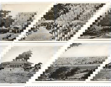
Collection of 17 Postcards - Temple Mount, JerusalemLevy Auction House4.3(11)See Sold PriceFeb 27, 2024
Collection of 52 Photographs - Jerusalem & PalestineLevy Auction House4.3(11)See Sold PriceFeb 27, 2024
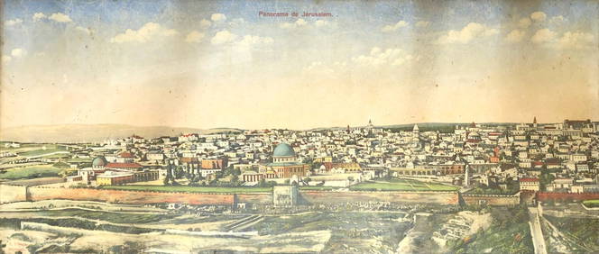
Panorama View of Jerusalem - L. Ferid - 19th CenturyLevy Auction House4.3(11)See Sold PriceFeb 27, 2024
Jerusalem Map for British Soldiers in Palestine - WW2Levy Auction House4.3(11)See Sold PriceFeb 27, 2024
Illustrated Sabbath Cloth - Holy Sites of Eretz IsraelLevy Auction House4.3(11)See Sold PriceFeb 27, 2024
1872 Holy BIBLE & Hitchcock Analysis Gruden Concordance Theology MAPS Holy LandSchilb Antiquarian Rare Books4.8(428)See Sold PriceMar 31, 2024
Georg Bockler Map of Ancient Jerulsaem EtchingAuctions at Showplace4.6(740)See Sold PriceApr 07, 2024
Antoine Augustin Calmet (1672-1757) - Set of 6 Architecture Engraving - Temple of Jerusalem -Proverde Auctions4.3(3)See Sold PriceFeb 28, 2024
THE ELEVEN WOMEN DRUM BY SHIRA HAIVRI. Jerusalem, 2023. Made from parchment. This piece is aboutJ. Greenstein & Co., Inc.4.2(55)See Sold PriceApr 16, 2024


![[Map] Map of the Holy Land. (1 of 1)](https://p1.liveauctioneers.com/928/104923/53749648_1_x.jpg?height=282&quality=70&version=1496865216)
![Collection of Jerusalem Maps. [27]. 15-19th Century. (1 of 9)](https://p1.liveauctioneers.com/2398/61770/30789838_1_x.jpg?height=282&quality=70&version=1412252439)