SoldFour maps of the Holy Land on one Sheet. Adrian Reland.Four different maps of the Holy Land on one sheet. Colored, copperplate engravings. According to Adrian Reland. By J.D. Kohler. From: Descriptio orbis antiqvi. Nuremberg, 1720. In the bottom right corSee Sold Price
Four maps of the Holy Land on one Sheet. Adrian Reland.Four different maps of the Holy Land on one sheet. Colored, copperplate engravings. According to Adrian Reland. By J.D. Kohler. From: Descriptio orbis antiqvi. Nuremberg, 1720. In the bottom right corSee Sold Price
SoldMap of the Holy Land. Adrian Reland. Nuremberg. 1716.Conspectus Palaestinae in Tabula Veteri Intineraria. Black and white, copperplate engraving by Jan Goeree. "Pag. 312" in the upper right corner. Quality paper. Very fine condition. Aging stains. 13.4xSee Sold Price
SoldMap of the Holy Land. Adrian Reland. Nuremberg. 1716?Conspectus Palaestinae divisae in Primam, Secundam et Tertiam, ut erat circa initium saeculi aerae Cristianae quinti. Map of the Holy Land during the Byzantine Empire. Copperplate engraving. AccordingSee Sold Price
SoldMap of the Holy Land. Adrian Reland. Nuremberg. 1716?Map of the Holy Land. onspectus Palaestinae et regionum, in quas distibuta fuit stante Templo. Secundo ... fit mentio. According to Josephus Flavius. Eusebii, Hieronymi, Epiphanii. Copperplate engraviSee Sold Price
SoldMap of the Holy Land. Adrian Reland. Nuremberg. 1716?onspectus Montium et Camporum palsestinae Fluminumque indicia. Map of the Holy Land according to Adrian Reland. Copperplate engraving. Engraved by J. Wandelaer. Black and white. "Pag 225" in the upperSee Sold Price
DuFour / Dyonnet: Three Holy Land Maps on one sheetCartographer: DuFour / Dyonnet Place/Date: Paris / 1860 Size: 30" x 21 1/2" Condition: wash color; light age toning Three superb, highly detailed and delicately colored Holy Land maps on a single sheeSee Sold Price
DuFour / Dyonnet: Three Holy Land Maps on one sheetThree superb, highly detailed and delicately colored Holy Land maps on a single sheet from the Atlas Universel published by Paulin & Le Chevalier. The largest of the maps, on the left side of the sheeSee Sold Price
Map of the Holy Land. Reland Adrian. Amsterdam, c.Facies Palaestinae ex Momentis Veteribus descripta ab Hadriano Relando. Map of the Holy Land by Reland Adrian. Amsterdam, c. 1715. Engraver's name in the bottom right corner: Puschner. In the upper riSee Sold Price
Map of the Holy Land during Roman Times. Adrian Reland.Facies Palaestinae ex Monumentis Veteribus descripta ab by Hadriano Relando. Map of the Holy Land on both banks of the Jordan. Roman times. By Adrian Reland. Utrecht, 1714. Shoreline from Sidon in theSee Sold Price
SoldWright, Paul 1782 Holy Land Map. Apostles Travels etcTwo maps on one sheet by Thomas Conder "A Map of the Countries where the Apostles Travell'd…" and "A Map of the more remote Places mentioned in the New Testament" Folio Copper Plate Published 1782,See Sold Price
SoldNOLIN, Jean Baptiste (ca 1657-1708). La Terre SainteNOLIN, Jean Baptiste (ca 1657-1708). La Terre Sainte Autrefois terre de Canaan et de Promission Divisee Selon Ses Douze Tribus. Paris, 1700. Engraved map on four sheets of the Holy Land, image 988 x 1See Sold Price
SoldAntique Wall Map of Middle EastColton's One Sheet Map of the Lands Mentioned in the Bible. Colton, Ohman & Co., New York: 1885. Wall map on cloth. Eastern Europe, Turkey, Holy Land, Israel. 25 1/2" x 37".See Sold Price
Antique Wall Map of Middle EastColton's One Sheet Map of the Lands Mentioned in the Bible. Colton, Ohman & Co., New York: 1885. Wall map on cloth. Eastern Europe, Turkey, Holy Land, Israel. 25 1/2" x 37".See Sold Price
Sanson (Nicolas) Terra Promissa, sive JudaeaSanson (Nicolas) Terra Promissa, sive Judaea,engraved map of the Holy Land, on two sheets, joined, hand-coloured, decorative title cartouche, 380 x 500mm., one repair to the upper left side, PSee Sold Price
SoldWorld Views 19th Century Lot of 300+ Illustrated SheetsBig lot of over 300 Sheets, each containing one or more Wood Engraving. All with veso text. Incl Holy Land, Italy, Asia, Norway, Arctic, North Africa, China, Japan, Australia, New Zealand etc. ExampleSee Sold Price
SoldMAP -- Homann Heirs. Dominia Anglorum in AmericaMAP -- Homann Heirs. Dominia Anglorum in America Septentrionali.Nuremberg: c. 1750. Double-page engraved map, hand-colored (515 x 570 mm). Four maps on one sheet, depicting Newfoundland, NewSee Sold Price
Homann (Heirs of) Dominia Anglorum in America SeptHomann (Heirs of) Dominia Anglorum in America Septentrionali,four maps on one sheet, including: Newfoundland & Nova Scotia; New England; Virginia & Maryland; Carolina, engraving with hand-coloSee Sold Price
SoldBritish Isles.- Channel Islands.- Mercator (Gerard)British Isles.- Channel Islands.- Mercator (Gerard) Anglesey, Ins. [on sheet with] Wight ol. Vectis [and] Ins. Garnesey [and] Ins. Iarsey, four maps on one sheet depicting the English islands of JerseSee Sold Price
Wall map of Holy Land on 6 sheetsTitle: [Holy Land] Dimida Tribus Manasse ... / Tribus Ruben, et Gad ... / Pars Maxima Tribus Iuda ... / Tribuum Ephraim ... / Tribus Aser ... / Tribus Simeon … Author: Jansson, Jan Description: CoppSee Sold Price
SoldA RARE AND EARLY JNF/KKL COLLECTION BOX. Germany, 1920A RARE AND EARLY JNF/KKL COLLECTION BOX. Germany, c. 1920. Embossed with a map of the Holy Land on one side and KKL insignia on the other. 4.7” tall.See Sold Price
DuVal map of the Holy Land on 2 sheets, 1666Title: Terra Sancta quæ et Terra Chanaan, Terra Promissionis. Terra Hebreorum, Terra Israelitarum, Iudæa, et Palestina; ex Veteri et Novo Testamento, et varijs Authoribus desupta... Author: Du Val,See Sold Price
SoldORTELIUS, ABRAHAM. Palestinae sive Totius TerraeORTELIUS, ABRAHAM. Palestinae sive Totius Terrae Promissionis Nova Descriptio. Double-page engraved map of the Holy Land. 17½x22¼ inches sheet size, wide margins, Latin text on verso; originSee Sold Price
SoldORTELIUS, ABRAHAM. Terra Sancta.ORTELIUS, ABRAHAM. Terra Sancta. Double-page engraved map of the Holy Land. 15½x20½ inches sheet size, narrow margins, German text on verso; original hand-coloring; closed tear into lower leSee Sold Price
New York Central and Hudson River RR Public Timetable-November 3, 1901JM Hobby Supply and Railroad Artifact Auctions4.4(127)See Sold PriceFeb 24, 2024
DAVID ROBERTS - Holy Land / Syria / Egypt etc. 3 x Folio Volumes 1849 Very RareLuis Porretta Fine Arts4.3(10)See Sold PriceMar 02, 2024
Jerusalem Map for British Soldiers in Palestine - WW2Levy Auction House4.3(11)See Sold PriceFeb 27, 2024
18 Booklets Collection - War Graves of Palestine - WWILevy Auction House4.3(11)See Sold PriceFeb 27, 2024
Dinah - Handwritten Poem - Shaul Tchernichovsky - 1936Levy Auction House4.3(11)See Sold PriceFeb 27, 2024
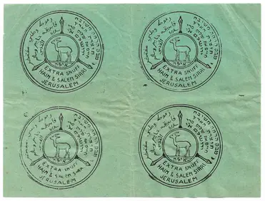
Sheet of Labels for Snuff Tobacco - Jerusalem, PalestineLevy Auction House4.3(11)See Sold PriceFeb 27, 2024
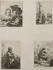
Rembrandt van Rijn. Four etchings, printed on one sheet of medium weight off-white wove paper, withTremont Auctions4.5(297)See Sold PriceFeb 25, 2024
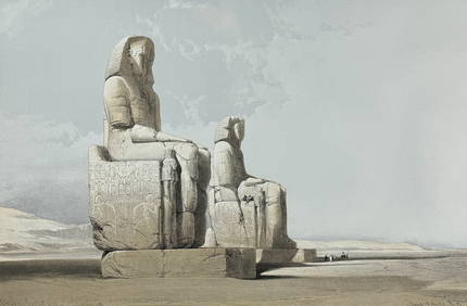
David Roberts - Obelisk of LuxorTrillium Antique Prints & Rare Books4.5(32)See Sold PriceFeb 24, 2024
David Roberts - Approach of the Simoom, Desert of GizehTrillium Antique Prints & Rare Books4.5(32)See Sold PriceFeb 24, 2024
STAR WARS: A NEW HOPE (1977) - Greg Hildebrandt-Signed Brothers Hildebrandt Poster with FourPropstore4.2(6)See Sold PriceMar 13, 2024
TWO ANTIQUE JEWISH NATIONAL FUND CHARITY BOXES. The first one made in Berlin c. 1920J. Greenstein & Co., Inc.4.2(55)See Sold PriceApr 16, 2024