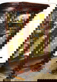
19th C. Carved Oak Curved Glass China CabinetPremier Auction Galleries4.3(327)See Sold PriceMar 09, 2024
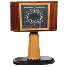
Osvaldo Borsani (1911-1985) Italian Zodiac Dry BarHill Auction Gallery 4.7(1000)See Sold PriceFeb 28, 2024
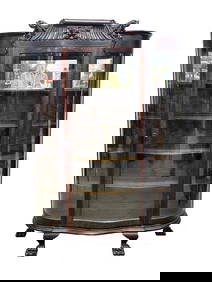
1960s ITALIAN MODERNIST ALDO TURA BAR CARTJohn McInnis Auctioneers,LLC4.5(494)See Sold PriceFeb 25, 2024
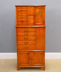
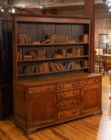
Slick Original Finish Horner Quality Oak Lion Head China CabinetRalph Fontaine Heritage Auctions Inc.4.7(234)See Sold PriceFeb 25, 2024
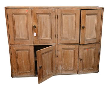
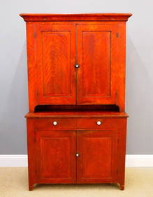
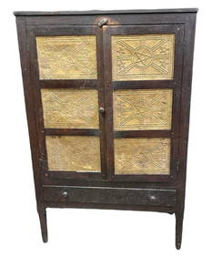
Early Walnut Pie Safe on Turned Legs in Wonderful "As Found" Condition 60"T 40"W 18"DSwisher Bros. Auction LLC4.5(237)See Sold PriceFeb 24, 2024
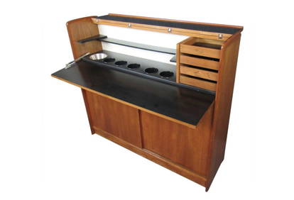
H.P. Hansen Designed Folding Danish Teak Dry BarA1 Consignment and Auction Gallery Inc4.4(16)See Sold PriceMar 07, 2024
SoldNicholas de Fer, Engraved Map"Carte de la Nouvelle France", map by Nicholas de Fer, 1646-1720, paraphrased, including St. Lawrence and Mississippi Rivers, peoples of Florida, Louisiana, and Virginia, for the establishment of "ComSee Sold Price
SoldScarce 1700s British Map of the East IndiesCreator: Edward Wells (British, 1667-1727). Based on map by Nicholas de Fer (1646-1720). Engraver: Sutton Nicholls (British, 1668-1729). Title: "A new map of the East Indies, taken from Mr. de Fer's mSee Sold Price
SoldNicholas de Fer (1646-1720)Nicholas de Fer (1646-1720), "Carte de la Nouvelle France ou se voit le cours des Grandes Rivieres de S. Laurens & de Mississipi Aujour d'hui S. Louis, aux Environs des quelles se Trouvent les Etats,See Sold Price
SoldMap - "Cadis Son Port, sa Rade, et ses environs"Map - "Cadis Son Port, sa Rade, et ses environs"dated 1705, Nicholas de Fer (1646-1720), hand-colored, matted and framed under glass.SS 10 x 13.75 in.; DOA 17.5 x 21 in.See Sold Price
SoldDe Fer Engraved Map of CaliforniaLa Californie ou Nouvelle Caroline, teatro de los trabajos, apostolicos de la campa e Jesus en la America...Nicholas de Fer (1646-1720). Engraved map. Paris, 1720. 19 x 27 inches visible, 28 1/2 x 36See Sold Price
Sold4 LOTS OF ANTIQUE MAPS4 LOTS OF ANTIQUE MAPS: 1) Nicholas de Fer (1646-1720), "Le Detroit de Magellan," 1705, Map of the Straits of Magellan. Approx. 11" h x 16.25" w. 2) 2 OLD CARTE D'ARTOIS MAPS: Pair of copper engravedSee Sold Price
''Le Detroit de Magellan,'' 1705, MapNicholas de Fer (1646-1720), ''Le Detroit de Magellan,'' 1705, Map of the Straits of Magellan. Approx. 11'' h x 16.25'' w.See Sold Price
SoldNicholas de Fer (1646-1720), "Le Detroit de Magellan,"Nicholas de Fer (1646-1720), "Le Detroit de Magellan," 1705, Map of the Straits of Magellan, shrink wrapped, H.- 10 in., W.- 14 in.See Sold Price
TWO EARLY 1700'S SMALL MAPS, MAGELLAN & BENZOSTwo early 1700s maps comprising Nicholas De Fer (French 1646-1720), "Le Detroit de Magellan", hand colored etching on paper of the straits of Magellan and Pieter van der Aa (Dutch 1659-1773), "H BenzoSee Sold Price
SoldDe Fer Map of Philippines, 1702DE FER, Nicholas (1646-1720). Les Isles Philippines... Engraved map with original hand color in outline. Paris, 1702. 9 1/4” x 13 3/4” visible,14” x 19” framed. The main map is primarily basedSee Sold Price
SoldDe Fer Map of California, 1720DE FER, Nicholas (1646-1720). La Californie ou Nouvelle Caroline, teatro de los trabajos, apostolicos de la campa e Jesus en la America… Engraved map with original color in outline. Paris, 1720.See Sold Price
SoldDe Fer Map of California as an IslandDe Fer, Nicholas (1646-1720). La Californie ou Nouvelle Caroline... Engraved map. Paris, 1720. 19" x 27" visible, 28 1/2" x 36 1/2" framed. Hard to find this stunning map of Califronia as an Island. TSee Sold Price
De Fer Map showing California as an IslandDE FER, Nicholas (1646-1720). La Californie ou Nouvelle Caroline... Engraved map with original color in outline. Paris, 1720. 18 1/2" x 26 1/2" visible, 28" x 36" framed. An impressive map depicting CSee Sold Price
De Fer California MapDe Fer, Nicholas (1646-1720). La Californie ou Nouvelle Caroline... Engraved map with original color in outline. Paris, 1720. 18 1/2" x 26 1/2" visible, 28" x 36" framed. An impressive map depicting CSee Sold Price
SoldDe Fer, Nicholas (French, 1646-1720)De Fer, Nicholas (French, 1646-1720), "Cartes et Descriptions Generales et Particulieres Pour l'Intelligence Des Affaires du Temps, au Sujet de la Sucession de la Couronne d'Espagne, en Europe, en AsiSee Sold Price
SoldNicolas de Fer (1646 - 1720)Les Isles Philippines et celles des larrons ou de Marianes 1702 hand-colored copperplate engraving 9” x 15 1/2” (23 cm x 34 cm)See Sold Price
Nicolas de Fer (1646 - 1720) Les forces de l' Europe,Nicolas de Fer (1646 - 1720) Les forces de l' Europe, ou description des principales villes; avec leurs fortifications. Dessignées par les meilleurs Ingenieurs, (...) don't les Plans ont esté leSee Sold Price
Nicolas de Fer (1646 - 1720 Paris), engraver A. CoquartNicolas de Fer (1646 - 1720 Paris), engraver A. Coquart Warsaw & Lowicz, 1705 copperplate/paper, 26,5 x 41,5 cm signed r.b.: 'A. Coquart Sculp' z: Atlas Curieux où le Monde représenté dans les cartSee Sold Price
SoldNicolas De Fer (1646-1720),'le Canada au NouvelleNicolas De Fer (1646-1720),'le Canada au Nouvelle France la Florida, la Virginie, Pensivanie, Caroline," 1702,hand colored, H. - 11 1/2 in., W. - 15 3/8 in.See Sold Price
SoldNicolas De Fer (1646-1720), "Cette Carte de CalifornieNicolas De Fer (1646-1720), "Cette Carte de Californie et du Nouveau Mexique," 1700, hand colored, H.- 11 1/2 in., W.- 15 1/4 in.See Sold Price
SoldNicolas De Fer (1646-1720), "Quebec," 1694, H.- 11 1/2Nicolas De Fer (1646-1720), "Quebec," 1694, H.- 11 1/2 in., W.- 15 1/2 in.See Sold Price
SoldNicolas De Fer (1646-1720)," Les Castes aux Environs deNicolas De Fer (1646-1720)," Les Castes aux Environs de la Riviere de Misisipi," 1701, H.- 11 1/4 in., W.- 15 1/4 in.See Sold Price
SoldNicolas De Fer (1646-1720), "Mappe Mondeou CarteNicolas De Fer (1646-1720), "Mappe Mondeou Carte Universal," 1702, hand colored, H. - 11 1/4 in., W.- 15 1/4 in.See Sold Price
St. Malo, 1693Map: St. Malo Maker: Nicolas de Fer (1646-1720) Date: 1693 Size: Quarto, 8.5 inches high x 10.30 inches wide "Ville de la Haut Bretagne..." L. Scherm, Fec. Please note that this lot has a reserve. WheSee Sold Price
Medieval Printed Paper Bible Page by Johann GrüningerTimeLine Auctions Ltd.4.5(183)See Sold PriceMar 07, 2024
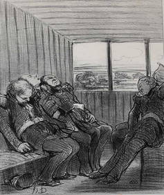
Honore Daumier France 1808 -1879 Lithograph En Chemin De Fer 1862Global Auctions Company4.3(36)See Sold PriceMar 03, 2024
Giovanni Piranesi Battista (Italian 1720-1778) Photolithograph Roman AntiquitiesGlobal Auctions Company4.3(36)See Sold PriceMar 03, 2024
Honore Daumier France 1808 -1879 Lithograph Le voyage... Le Charivari 1848Global Auctions Company4.3(36)See Sold PriceMar 03, 2024
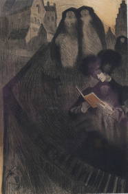
Georges de Feure (Dutch 1868-1943) Lithograph Les Maitres de l'AfficheGlobal Auctions Company4.3(36)See Sold PriceMar 03, 2024
ACCOLAY : Taureau en céramique noire et fil de fer. Annotation au revers. H : 13 - L : 17 cm.Valoir Pousse-Cornet4.3(4)See Sold PriceFeb 24, 2024
JULIEN LACAZE (1886-1971) LA CÔTE BRETONNE / CHEMINS DE FER DE L'ÉTAT. 1914.Swann Auction Galleries4.4(64)See Sold PriceFeb 29, 2024
Chinese snuff bottle in porcelain 'figures', RepublicMarques Dos Santos, Lda4.4(39)See Sold PriceMar 01, 2024
Chinese porcelain figural snuff bottle, RepublicMarques Dos Santos, Lda4.4(39)See Sold PriceMar 01, 2024
COLONIAL GABON & CONGO. Afrique équatoriale française. Brazzaville plan 1929 mapJasper524.5(9.7k)See Sold PriceFeb 28, 2024
COLONIAL GABON & CONGO. Afrique équatoriale française. Brazzaville plan 1938 mapJasper524.5(9.7k)See Sold PriceFeb 28, 2024
Chemins De Fer Belges - Art By Van Doren (1928) Belgian Advertising Poster LBJasper524.5(9.7k)See Sold PriceFeb 28, 2024
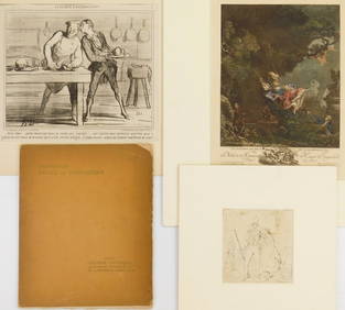
3 Works on paper and a catalog on Henry de WaroquierRachel Davis Fine Arts4.7(471)See Sold PriceMar 02, 2024