SoldBernard Jaillot map of FranceCartographer: Bernard Jaillot Title: Nouvelle Carte des Postes de France Subject: France Published: Paris Date: 1726-1731 Description: Jaillot's map of the post roads of France first appeared in a 163See Sold Price
SoldAlexis H. Jaillot map of FranceCartographer: Alexis Hubert Jaillot Title: Galliae Regnum in Omnes Suas Provincias Accurat‚ Divisum ad Usum Serenissimi Burgundiae Ducis Subject: France Published: Amsterdam Date: 1720 Description:See Sold Price
SoldJaillot Map of New FranceJAILLOT, Alexis Hubert (1632-1712). Partie de la Nouvelle France. Engraved map with hand color in outline. Paris, 1685. 30" x 27" sheet.See Sold Price
Jaillot Engraved Map of France Post RevolutionCarte des Postes de France pour L'Annee 1786...Alexis-Hubert Jaillot (1632-1712). Engraved map with very fine color. Paris, 1786. 25 1/2 x 31 inches sheet. The Best Map of France before the RevolutionSee Sold Price
Jaillot map of Artois in France 1693Title: Le Comté d'Artois suivant qu'il presentemet divisé en François et Espagnol... Author: Jaillot, Hubert Description: Copper-engraved map, hand-colored in outline. 42.5x56.5 cm. (16¾x22¼").ArSee Sold Price
Jaillot: Map of The Post Roads of France, 1780Map: The Post Roads of France, Maker: Robert Sayer, Sayer, Robert/jaillot Publication Date: 1780-03-02 Publisher: Robert Sayer Size: Folio – 18.25 H x 22.30 W Inches "from the map of Jaillot. PublisSee Sold Price
France, Paris Wall Map 1706 Jaillot, Alexis-Hubert - Carte environs de Paris..France, Paris Wall Map 1706; Jaillot, Alexis-Hubert (1632?-1712) - Carte particulière des environs de Paris et des pays.. Size: 27.55" x 40.15" inches / 70 cm x 102 cm. Technique: Engraving with haSee Sold Price
France, Paris Wall Map 1706 Jaillot, Alexis-Hubert - Carte environs de Paris..France, Paris Wall Map 1706; Jaillot, Alexis-Hubert (1632?-1712) - Particular map of the surroundings of Paris and the countries. Date: 1706. Size: 27.55" x 40.15" inches / 70 cm x 102 cm. Reserve: $8See Sold Price
Jaillot Map of Eastern CanadaPartie de la Nouvelle France. Alexis Hubert Jaillot (1632-1712). Engraved map with hand color in outline. Paris, 1685 (first state). 20 x 27 inches sheet. Map of Canada by the French cartographer, focSee Sold Price
Jaillot Map of Canada and Hudson BayLa Canada ou Partie de la Nouvelle France. Alexis Hubert Jaillot (1632-1712). Engraving with original hand color in outline. Paris, 1696. 20 1/4 x 25 inches sheet. First state, dated 1696, of Jaillot�See Sold Price
SoldTwenty-Two Antique Maps of FranceTwenty-Two Antique Maps of France, 1707-1760, double-sheet, hand-colored in outline, incl. a map of the whole of France by Janvier, and 21 maps of the different departments by Vaugondy, Jaillot and BuSee Sold Price
Sold[Map] Jaillot, Charles Hubert Alexis. La Bretagne[Map] Jaillot, Charles Hubert Alexis. La Bretagne. [Amsterdam], 1696. Engraved map of the Bretagne region of France, with original hand-coloring in outline and hand-colored cartouches. Cartouches featSee Sold Price
SoldFrance.- Provence.- Jaillot (Alexis-Hubert) La ProvenceFrance.- Provence.- Jaillot (Alexis-Hubert) and Joshua Ottens. La Provence Divisée en ses Vigueries, et Terres Adjacentes, regional map of France, from 'Atlas Francois', engraving with early handSee Sold Price
RARE 17TH C. SANSON MAP OF FLEMISH FRANCEAlexis-Hubert Jaillot (c. 1632-1712); Nicolas Sanson (1600-1667) "Le Comte d'Artois, Dresse sur les Memoires les plus Nouveaux....", hand colored engraving, published 1700 from earlier plates, Paris,See Sold Price
Post Roads of France,Publication Date: 1780-03-02 Title: Post Roads of France, Cartographer: SAYER, ROBERT/JAILLOT Publisher: ROBERT SAYER Height: 18.25 Width: 22.3 "from the map of Jaillot. Published by order of the DukeSee Sold Price
RARE 17TH C. SANSON MAP OF FLEMISH FRANCEAlexis-Hubert Jaillot (c. 1632-1712); Nicolas Sanson (1600-1667) "Le Comte d'Artois, Dresse sur les Memoires les plus Nouveaux....", hand colored engraving, published 1700 from earlier plates, Paris,See Sold Price
Sold17TH C. FRENCH COLORED MAP, LE ROYAUME DE FRANCEH. Jaillot, 1692, Paris impression 23 by 35.5 in.; framed under glass 25 by 37" Glued on reverse to backing, the printed Table Alphabetique de tous les Mots......See Sold Price
Sold1711 Spain and Portugal hand-colored map. Very large1711 Spain and Portugal hand-colored map. Very large Alexis Hubert Jaillot (France 1632-1712) copper-engraving, hand-colored map. Sheet size 37'' x 51''. Professionally framed ''floating''. Good condiSee Sold Price
SoldJAILLOT, HUBERT. Partie de la Nouvelle France.JAILLOT, HUBERT. Partie de la Nouvelle France. Double-page engraved map of Canada, 465x650 mm, wide margins, nicely hand-colored; nicely repaired tear extending from the top margin just to the cartoucSee Sold Price
SoldJaillot PARTIE DE LA NOUVELLE FRANCE 1695 ImportantDetails: JAILLOT, Alexis Hubert (c.1632-1712). Partie de la Nouvelle France. Paris: 1695. Engraved map. Sheet size: 21 1/4 x 28 1/2 inches. An important French mapping of Canada during King William'sSee Sold Price
SoldFrance.- Brittany.- Jaillot (Alexis-Hubert) and JoshuaFrance.- Brittany.- Jaillot (Alexis-Hubert) and Joshua Ottens. La Bretagne Divisée en ses Neuf Eveschés, map of the Brittany region of France, engraving with early hand-colouring on laid papSee Sold Price
SoldJAILLOT, ALEXIS HUBERT. Les Montagnes des AlpeJAILLOT, ALEXIS HUBERT. Les Montagnes des Alpes . . . les Passages de France en Itlaie. Engraved two-sheet map joined, 575x875 mm, wide margins; hand-colored in outline; 220-mm tear extending into imaSee Sold Price
Sold1 piece. Engraved Map with Outline Color. Sanson,1 piece. Engraved Map with Outline Color. Sanson, d'Abbreville, Nicolas. Les Monts Pyrenees, ou Sont Remarques les Passages de France en Espange." Paris: A.H. Jaillot, 1675. Double sheet, 22 x 34 5/8See Sold Price
SoldAtlases.- Jaillot (Alexis-Hubert) Composite atlasNO RESERVE Atlases.- Jaillot (Alexis-Hubert) and others. Composite atlas containing 62 double-page maps, including maps by Nolin, De L'Isle, and others, many of France, Germany, Italy, Eastern Europe,See Sold Price
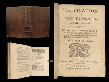
1683 Edict of Nantes Protestant Reform Catholic France Huguenot Soulier BernardSchilb Antiquarian Rare Books4.8(428)See Sold PriceMar 10, 2024
LARGE LATE 17TH C. DUTCH CHART OF CANADA, GREAT LAKES, NEW FRANCE, LABRADOR, HUDSON BAY, BY PIERREThomaston Place Auction Galleries4.4(393)See Sold PriceFeb 24, 2024
ABRAHAM ORTELIUS (1527-1598) MAP OF ROMAN GAUL (FRANCE)Thomaston Place Auction Galleries4.4(393)See Sold PriceFeb 24, 2024
1849 Mitchell School ATLAS 24 MAPS America Holy Land France Africa Egypt AsiaSchilb Antiquarian Rare Books4.8(428)See Sold PriceMar 31, 2024
Bernard Buffet Lithograph Sad Clown Signed in Plate '55Heritage Gallery Auctions4.4(60)See Sold PriceMar 10, 2024
Bernard Dufour Pencil Signed Original Lithograph L'ecran 1972Jasper524.5(9.9k)See Sold PriceFeb 28, 2024
Antique Map of France, 1703 by Gillaume Del Isle PrintAntiques Online Auctions4.6(415)See Sold PriceMar 14, 2024
Baccarat France Bernard Augst Signed Large Owl Crystal Art SculptureActivity Auctions4.5(357)See Sold PriceFeb 27, 2024
Galliae Regionis Nova Descriptio Hand Colored Map of France on Laid Paper, Ca. 16th Century, H 10" WDuMouchelles4.6(830)See Sold PriceMar 15, 2024


![[Map] Jaillot, Charles Hubert Alexis. La Bretagne (1 of 1)](https://p1.liveauctioneers.com/928/104923/53749645_1_x.jpg?height=282&quality=70&version=1496865216)