John Melish - Map Of New Orleans And Adjacent Country,John Melish - Map Of New Orleans And Adjacent Country, 1815 - 40 X 29 3/8 In. - Giclée On Canvas - Museum Wrapped - Large Piece Of Art - This Piece Is Ready To Hang On Your WallSee Sold Price
JOHN MELISH - MAP OF NEW ORLEANS AND ADJACENT COUNTRY,John Melish - Map Of New Orleans And Adjacent Country, 1815 - 40 X 29 3/8 In. - Giclée On Canvas - Museum Wrapped - Large Piece Of Art - This Piece Is Ready To Hang On Your WallSee Sold Price
JOHN MELISH - MAP OF NEW ORLEANS AND ADJACENT COUNTRY,John Melish - Map Of New Orleans And Adjacent Country, 1815 - 40 X 29 3/8 In. - Giclée On Canvas - Museum Wrapped - Large Piece Of Art - This Piece Is Ready To Hang On Your WallSee Sold Price
JOHN MELISH - MAP OF NEW ORLEANS AND ADJACENT COUNTRY,John Melish - Map Of New Orleans And Adjacent Country, 1815 - 36 X 26 3/8 In. - This Giclée Print Is Gallery Stretched And Ready To Hang Or Lean Against A Wall, Or Display On An Easel. - A Giclée PrSee Sold Price
JOHN MELISH - MAP OF NEW ORLEANS AND ADJACENT COUNTRY,John Melish - Map Of New Orleans And Adjacent Country, 1815 - Giclée On Canvas - 30 X 22 In. - A Giclée Print Is The Highest Quality Print Available Today. Because There Is No Visible Dot Screen PatSee Sold Price
JOHN MELISH -MAP OF NEW ORLEANS AND ADJACENT COUNTRY,John Melish -map Of New Orleans And Adjacent Country, 1824 - Giclée On Canvas -40 X 29 3/8 In. - A Giclée Print Is The Highest Quality Print Available Today. Because There Is No Visible Dot Screen PSee Sold Price
JOHN MELISH - MAP OF NEW ORLEANS AND ADJACENT COUNTRY,John Melish - Map Of New Orleans And Adjacent Country, 1815 - 40 X 29 3/8 In. - This Giclée Print Is Gallery Stretched And Ready To Hang Or Lean Against A Wall, Or Display On An Easel. - A Giclée PrSee Sold Price
JOHN MELISH - MAP OF NEW ORLEANS AND ADJACENT COUNTRY,JOHN MELISH - MAP OF NEW ORLEANS AND ADJACENT COUNTRY, 1815 - Giclée on Canvas 36 x 26 3/8 in. - A Giclée Print Is The Highest Quality Print Available Today. Because There Is No Visible Dot Screen PSee Sold Price
John Melish - Map Of New Orleans And Adjacent Country,John Melish - Map Of New Orleans And Adjacent Country, 1824 Size: 44 X 32 3/8 In. - This Is A Gallery Stretched Giclee Print On Canvas. The Piece Was Printed On High Quality Artist Grade 350 Gsm, AcidSee Sold Price
JOHN MELISH - MAP OF NEW ORLEANS AND ADJACENT COUNTRY,John Melish - Map Of New Orleans And Adjacent Country, 1815 - 44 X 32 1/4 In. - Gallery Stretched The Piece Of Art Is Ready To Hang Or Lean Against A Wall, Or Display On An Easel. - A Giclée Print IsSee Sold Price
JOHN MELISH - MAP OF NEW ORLEANS AND ADJACENT COUNTRY,John Melish - Map Of New Orleans And Adjacent Country, 1815 - 40 X 29 3/8 In. - This Giclée Print Is Gallery Stretched And Ready To Hang Or Lean Against A Wall, Or Display On An Easel. - A Giclée PrSee Sold Price
JOHN MELISH - MAP OF NEW ORLEANS AND ADJACENT COUNTRY,John Melish - Map Of New Orleans And Adjacent Country, 1815 - 44 X 32 1/4 In. - Gallery Stretched The Piece Of Art Is Ready To Hang Or Lean Against A Wall, Or Display On An Easel. - A Giclée Print IsSee Sold Price
JOHN MELISH -MAP OF NEW ORLEANS AND ADJACENT COUNTRY,John Melish -map Of New Orleans And Adjacent Country, 1815 - Giclée On Canvas -40 X 29 3/8 In. - A Giclée Print Is The Highest Quality Print Available Today. Because There Is No Visible Dot Screen PSee Sold Price
JOHN MELISH - MAP OF NEW ORLEANS AND ADJACENT COJohn Melish - Map Of New Orleans And Adjacent Country, 1824 - Giclée On Canvas - 44 X 32 3/8 In. A Giclée Print Is The Highest Quality Print Available Today. Because There Is No Visible Dot Screen PSee Sold Price
JOHN MELISH - MAP OF NEW ORLEANS AND ADJACENT COJohn Melish - Map Of New Orleans And Adjacent Country, 1824 - Giclée On Canvas - 40 X 29 3/8 In. A Giclée Print Is The Highest Quality Print Available Today. Because There Is No Visible Dot Screen PSee Sold Price
JOHN MELISH - MAP OF NEW ORLEANS AND ADJACENT COUNJohn Melish - Map Of New Orleans And Adjacent Country, 1815 - Giclée On Canvas - 44 X 32 1/4 In. A Giclée Print Is The Highest Quality Print Available Today. Because There Is No Visible Dot Screen PSee Sold Price
MAP OF NEW ORLEANS AND ADJACENT COUNTRY, 1815 … JOHNJohn Melish - Map Of New Orleans And Adjacent Country, 1815 - 22 X 16 1/8 In. - This Giclée Print Is Gallery Stretched And Ready To Hang Or Lean Against A Wall, Or Display On An Easel. - A Giclée PrSee Sold Price
SoldJohn Melish (Scottish/American)John Melish (Scottish/American, 1771-1822), "Map of New Orleans and Adjacent Country", Philadelphia, John Melish, 1815, hand-colored engraved map, with folds, as issued, from A Military and TopographiSee Sold Price
JOHN MELISH"MAP OF NEW ORLEANS AND ADJACENT COUNTRThis Is A JOHN MELISH Giclee on CANVAS Titled "MAP OF NEW ORLEANS AND ADJACENT COUNTRY, 1824"Measuring - 30 x 22 in.This Giclée is high-resolution and of the highest quality, has a color permanence rSee Sold Price
SoldMap of New Orleans and Adjacent Country"Map of New Orleans and Adjacent Country" by John Melish (Scottish/American, 1771-1822), hand-colored engraved map from A Military and Topographical Atlas of the United States, published Philadelphia,See Sold Price
MAPS - Eastern US Cities. MelishEastern United States Cities. John Melish, [Lot of 7] New-York, and Adjacent Country [and] District of Columbia [and] Boston... [and] Baltimore, Annapolis... [and] Charleston... [and] View of the CounSee Sold Price
SoldJohn La TourretteJohn La Tourrette, "Correct Map of the Seat of War and adjacent Country, Compiled from the best Authorities, Extant by John LaTourrette New-Orleans A.D. 1846", printed by Risso Lith., Dumaine St. No.See Sold Price
SoldCORRECT MAP OF THE SEAT OF WAR AND ADJACENT COUNTRY,CORRECT MAP OF THE SEAT OF WAR AND ADJACENT COUNTRY, COMPILED FROM THE BEST AUTHORITIES, EXTANT BY JOHN LATOURRETTE, NEW ORLEANS, RISSO LITHO, 1846, shows locations of the Mexican and American armiesSee Sold Price
SoldAmerica.- Bowen (Emanuel) A New & Accurate Map ofAmerica.- Bowen (Emanuel) A New & Accurate Map of Louisiana, with Part of Florida and Canada, and the Adjacent Countries; A New & Accurate Map of the Islands of Newfoundland, Cape Breton, St. John andSee Sold Price
1888 O Morgan Silver Dollar PCGS MS-61 VAM 1A - CLASHED E - TOP 100Mynt Auctions4.6(680)See Sold PriceFeb 27, 2024
1880 O Morgan Silver Dollar PCGS AU-55 VAM 49 8/7 Ear Hangnail - Top 100 - WhiteMynt Auctions4.6(680)See Sold PriceFeb 28, 2024
1889 O Morgan Dollar PCGS XF-40 - CAC - VAM 1A - Clashed E - Top 100Mynt Auctions4.6(680)See Sold PriceFeb 28, 2024
1888 O Morgan Silver Dollar NGC MS-63 O VAM-1A "E" CLASH TOP 100Mynt Auctions4.6(680)See Sold PriceFeb 29, 2024
1884 O Morgan Silver Dollar NGC MS-64 - Rainbow ToningMynt Auctions4.6(680)See Sold PriceFeb 29, 2024
1888 O Morgan Silver Dollar NGC MS-64 O VAM-1A "E" CLASHMynt Auctions4.6(680)See Sold PriceFeb 29, 2024
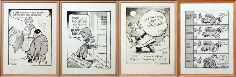
John Churchill Chase (1905-1986, New Orleans), Four Original Ink Editorial Cartoons, c. 1953-1954,Crescent City Auction Gallery4.3(229)See Sold PriceMar 01, 2024
1738 RUSSIA SIBERIA & GREAT TARTARY Description illustrated ANTIQUE in ENGLISHJasper524.5(9.8k)See Sold PriceFeb 27, 2024
1888 O Morgan Silver Dollar PCGS MS-61 VAM 1A - CLASHED E - TOP 100 Sight WhiteMynt Auctions4.6(680)See Sold PriceMar 01, 2024
Morgan Silver Dollar 1889 O PCGS AU-55VAM 20A - Weak E Rev - Hot 50Mynt Auctions4.6(680)See Sold PriceMar 01, 2024
Two Hand-Colored 19th Century Maps of New Orleans and Louisiana, Larger- H.- 12 1/2 in., W.- 15 1/2Crescent City Auction Gallery4.3(229)See Sold PriceMar 08, 2024
Stanford, Edward 1901 Large Map. Burma and Adjacent CountriesAlbion Auctions4.6(336)See Sold PriceMar 01, 2024