SoldEarly map of Southeast AsiaHeading: (Asia - Southeast) Author: Ruscelli, Girolamo Title: India Tercera Nvova Tavola Place Published: Venice Publisher: Date Published: 1562 Description: Copper-engravedSee Sold Price
SoldEarly Map of the SoutheastVirginiae item et Floridae Americae Provinciarum, nova Descriptio, by Jodocus Hondius, 1606 or later copy, from Mercator's [Atlas,] originally published in Amsterdam, double-page hand-colored map of tSee Sold Price
SoldLate 16th / Early 17thc Map of South East England,Gerard Mercator ( 1565 - 1656 ) engraved map of "South East England". With Latin text to the reverse, in modern Hogarth frame with glass to both sides.14 1/2" X 18 1/2". Provenance : R. Deverall, DuvaSee Sold Price
Sold5V US Reference HISTORY OF MAPS OF NORTH AMERICA USA5V US Reference HISTORY OF MAPS OF NORTH AMERICA USA Cartography Books-On-Books 19th Century Alabama Dr John Mitchell Atlas Joseph Scott Southeast Early Maps Annotated Checklist Printed Manuscript LocSee Sold Price
SoldEarly Map of the American Southeastlikely 17th century. entitled “Virginiae partis australis, et Floridae partis orientalis, interjacentiumqus regionum Nova Descriptio.” engraving by Jan Jansson after the circa 1638 work of WillemSee Sold Price
Sold3 Books incl: Cumming THE SOUTHEAST IN EARLY MAPS.[Reference] 3 Titles. 8vo/4to. Cloth (2 in dj). Very good to near fine. ++ R. V. Tooley. THE MAPPING OF AMERICA. Holland Press, (1980). Minor creasing, short tears, and wear to dj’s edges. ++ WilliaSee Sold Price
SoldAntique Map of India, 1812Early 1812 Antique "Map of the SOUTH EAST part of ASIA for illustrating Dr. Robertson's Historical Disquisition &c."; as found and removed from the book, "An Historical Disquisition concerning the knoSee Sold Price
SoldSpice Islands Southeast Asia Antique MapSpice Islands Southeast Asia antique map. An early map of Italy. Loose, unframed and not glued or mounted, etc. m). Sheet size 18 3/4" x 24 3/4". Fair to good condition with tears in margin and paperSee Sold Price
SoldPhilippinesTitle/Content of Map: Philippines Date Printed: 1752 Cartographer: Bellin, Jacques Nicolas Size (in): 6 x 8 Early map of the Philippines Islands by Bellin after Velarde . Dated 1752 in cartouche PleasSee Sold Price
SoldSpice islands. (Indonesia, Malaysia, mainland S.ETitle/Content of Map: Spice islands. (Indonesia, Malaysia, mainland S.E Asia.) Date: 1576-1590. Cartographer: Porchelli Size: 8x12”. Provenance: Republic of Venice A Rare very early map to focus onSee Sold Price
SoldMap of the Seaboard Air Line, 1895Map of the Seaboard Air Line and its principle connections north, south, east and west, published in 1895 by Rand, McNally & Co. 10 x 11.875 inches. Hard to find this map in such an early version. ThiSee Sold Price
SoldMatthaus Merian,c.1638, India Orientalis MapMatthaus Merian, Swiss, 1593-1650, c.1638 Hand Colored Map of India Orientalis et Insulae Adiecentes (with early discoveries in Western Australia) includes Southeast Asia, China, India, the PhilippineSee Sold Price
SoldTWIN HEMISPHERE MAP OF THE WORLD 1777 BY A. BELLEngraved by A. Bell, 1777. Plate CCXIV. Santa Fe is the only N. American city listed, early states of the US southeast are outlined. Professionally matted in archival material, 9 x 14.5 inches.See Sold Price
SoldAMERICAN / NORTH AMERICAN GARDENING / LANDSCAPE HISTORYAMERICAN / NORTH AMERICAN GARDENING / LANDSCAPE HISTORY VOLUMES / RESEARCH MATERIALS, LOT OF 31, primarily related to historical American gardens and landscapes, including "The Southeast in Early MapsSee Sold Price
SoldRARE EARLY MAP OF NORTH AMERICA - Matthias Seutter,RARE EARLY MAP OF NORTH AMERICA - Matthias Seutter, copperplate engraving on laid paper, with later hand coloring, circa 1730; "Recens Edita Totius novi Belgii in America Septentrionali siti DelineatoSee Sold Price
SoldEarly Map LotLot of misc. early assorted maps. Funds to Benefit St. Judes Research Hospital.See Sold Price
SoldGroup of Early MapsGroup of Early Maps. Americae Nova description Impensis Anae Seile, 1663(14" x 16 1/2"); William C. Woodbridge United States Map, 1821 (12 1/2" x 19 1/2"); A New Map of America, 1799, by Mr. WauthierSee Sold Price
SoldEarly MapEarly map "Carte Des Troubles De L ' Amerique...New York...New Jersey...Paris". Some damage. Sight 28 1/2" x 21".See Sold Price
SoldEarly Map: "A New Map Of North America...."Early map: "A New Map Of North America Showing its Principal Divisions....Dedicated To His Highness William Duke Of Gloucester...". Dated 1573. Sight 15" x 19 1/2".See Sold Price
SoldEARLY MAP EUROPAColor engraving of Europe in 1595; Clariss D. Nicolao, toning; 17" x 21", F-GSee Sold Price
SoldEARLY MAP OF A HUDSON RIVER TOWN (18TH / 19TH CEN)Engraved map of Hudson River bordering town. Town unidentified on map. Dimensions: (Frame) H 18” x W 30.5” (Paper) H 15” x W 27.5” Condition: Trimmed to border. Paper with some toning, spots,See Sold Price
SoldSeutter Early Map Transylvania, RomaniaEarly map: Transylvaniae Principatus. Hand-colored engraving. Matthaus Seutter, Augsburg, 18th Century. 20 1/4" x 24".See Sold Price
SoldEarly Map of North AmericaEarly Map of North America. New York, New Jersey and part of Pennsylvania. c. 1776. 55" x 21 1/2". A Prominent Buffalo, NY Family.See Sold Price
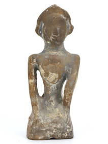
500 to 1500 yr old Southeast Asian bronze drum "Hager type 1" drum. Early Type- Fine Patina!The Buddha Gallery4.4(29)See Sold PriceMar 13, 2024
LARGE GULF SERVICE STATION MAP COLLECTION WITH DISPLAY STAND.Dan Morphy Auctions4.2(1.3k)See Sold PriceFeb 24, 2024
Pair of Early Railroad Maps - 1874 Delaware, Lackawanna & Western and 1876 Pennsylvania RailroadRail & Road Auctions4.6(165)See Sold PriceMar 07, 2024
Pair of Early Railroad Maps - 1862 Pittsburgh, Ft. Wayne & Chicago Railway and 1873 PennsylvaniaRail & Road Auctions4.6(165)See Sold PriceMar 07, 2024
A 1975 Walt Disney World Magic Kingdom Souvenir Map.Van Eaton Galleries4.6(99)See Sold PriceMar 02, 2024
INDIA WITHIN THE GANGES SUSAN GOLE ILLUSTRATED MAPS EARLY CARTOGRAPHYJasper524.5(9.8k)See Sold PriceFeb 27, 2024
WEST AFRICA Explorers' routes Senegal Ashanti. Mountains of Kong. SDUK 1857 mapJasper524.5(9.8k)See Sold PriceFeb 28, 2024
AFRICA. Map pre-dating much exploration. Mountains of Kong. SDUK 1851 oldJasper524.5(9.8k)See Sold PriceFeb 28, 2024
WEST AFRICA explorers' routes. Beaufort Gray Park Dochard Caillie. SDUK 1874 mapJasper524.5(9.8k)See Sold PriceFeb 28, 2024
WEST AFRICA I Explorers' routes Senegal Ashanti Ivory Gold Coast. SDUK 1851 mapJasper524.5(9.8k)See Sold PriceFeb 28, 2024
WEST AFRICA showing early explorers' routes & Mountains of Kong. SDUK 1844 mapJasper524.5(9.8k)See Sold PriceFeb 28, 2024
PRE COLONIAL WESTERN AFRICA. Shows Mountains of Kong. Tribes. WELLER 1863 mapJasper524.5(9.8k)See Sold PriceFeb 28, 2024