SoldTWO UNFRAMED MAPS OF FALL RIVER FROM 1895BRISTOL COUNTY ATLAS; "CITY OF FALL RIVER" AND "CITY OF FALL RIVER WARDS 4, 5, & 6"; 22" X 32" AND 23 1/2" X 15 1/2".See Sold Price
SoldUNFRAMED MAP "PART OF THE CITY OF FALL RIVER"FROM THE 1895 BRISTOL COUNTY ATLAS; 22" X 32".See Sold Price
SoldUNFRAMED MAP OF "THE CITY OF FALL RIVER", MA,FROM BRISTOL COUNTY ATLAS 1871; 15 5/8" X 23 5/8".See Sold Price
SoldGROUP LOT OF PAPER GOODS(5) INCLUDING - TWO BRUCKTOWN AND PLYMOUTH RAILWAY CO. MAPS - WIARD PLOW ADV. - "VIEWS OF FALL RIVER LINE" NEW YORK TO BOSTON - 1876 CENTENNIAL SOUVENIR, PHILADELPHIA , 3 1/4" TO 6 1/2" HSee Sold Price
Sold8 framed AW Langster prints of the Niagara River8 Framed AW Langster pencil signed etchings of the Niagara River and Niagara Falls Taken from Niagara area train station prior to demolition, with two unframed AW Langster prints and spare frame plateSee Sold Price
SoldHugh Laidman. Three Watercolor LandscapesHugh Laidman (American, 1914-1987). Three watercolor on paper landscapes to include a farmhouse, river scene, and fall nature landscape. Two signed lower right. Unframed. Largest sheet measures 22-1/4See Sold Price
SoldTWO LANDSCAPES BY ROBERT BRUBAKER (OHIO, 1921-2011).Oil on artist board, signed. Fall river, 12”h. 18”w. and winter mountains. Additional signature. 16”h. 20”w. Unframed.See Sold Price
1854 CLERK'S COPY OF 1788 INKED LINEN MAP OF ORLAND, MA ON THE PENOBSCOT (ME), UNFRAMEDInscribed in cursive cartouche: "Plan of the Westerly part of the Township Number Two, on the east side of the Penobscot River with the lots Survey'd and laid out by the Proprietors of the said TownshSee Sold Price
SoldLondon and the River Lea.- Jefferys (Thomas) A Plan ofLondon and the River Lea.- Jefferys (Thomas) A Plan of the River Lee from Hertford to the River Thames, with a Profile of the Fall, engraving on two sheets joined, sheet 274 x 960 mm. (10 3/4 x 37 3/4See Sold Price
SoldTwo unframed maps, China and British Guayana, togetherTwo unframed maps, China and British Guayana, together with an engraving after GillraySee Sold Price
SoldTWO UNFRAMED MAPS OF NEW BEDFORD ANDACUSHNET FROM 1881 ATLAS; 22" X 32"; 17 1/2" X 28".See Sold Price
SoldTWO FALL RIVER LINE PRINTS Early 20th Century Largest framed 26î x 41.5î.TWO FALL RIVER LINE PRINTSEarly 20th CenturyìFall River Line Old Colony Steamboat Companyî and ìOn The Old Fall River Lineî.Largest framed 26î x 41.5î.See Sold Price
Two unframed maps, China and British Guayana, togetherTwo unframed maps, China and British Guayana, together with an engraving after GillraySee Sold Price
SoldAntique Railroad Map, Fall River LineHand-colored copper engraved map depicting the "Fall River Line, Old Colony R.R. & Steamboat Co.'s and Connections," engraved and printed by R.A. Supply Co. (Boston, MA), overall (framed): 15.5"h x 19See Sold Price
SoldTwo Maps of the American North WestLot of two unframed maps of the American North West, one published by Alvin Johnson & Son, New York (18" h x 14" w), the other published by S. Augustus Mitchell (12 1/4" h x 15 1/4" w). Provenance: FrSee Sold Price
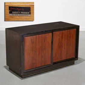
SoldHarvey Probber for Harvey Probber, Inc. cabinets, twoHarvey Probber for Harvey Probber, Inc, cabinets, two, Fall River, MA, 1960s, mahogany, rosewood, signed with Harvey Probber tag, left: 62''w x 18''d x 32.75''h, right: 42''w x 18''d x 32.75''hSee Sold Price
SoldBOOK OF 1904 INSURANCE MAPS OF FALL RIVER, MA 25BOOK OF 1904 INSURANCE MAPS OF FALL RIVER, MA 25.5"X22.5"X3"See Sold Price
SoldAntique maps, 19th centuryLot of two unframed antique maps, "West Indies" circa 1864 and "Pennsylvania & New Jersey" circa 1864 by A.J. Johnson, 18" x 26.5" eachSee Sold Price
SoldHarold C. Dunbar (American, 1882-1953) Lot of TwoHarold C. Dunbar (American, 1882-1953) Lot of Two Fall Landscapes: River View and Distant View. Signed and dated "Harold Dunbar '10" l.l. and l.r., respectively. Oil on canvas, both 11See Sold Price
SoldP. Coronelli 1683 2 Maps of Irelanda, 18 x 24 insP. Coronelli 1683 two unframed engravings, Map of Irelanda, top half only, 18 x 24 ins.See Sold Price
SoldRobert Mordon Maps of Leicester ShireRobert Mordon two unframed engravings Maps of Leicester Shire 15in. x 17in. and a Cary map of LeicestershireSee Sold Price
SoldTwo Maps: The Missouri River Basin and MassachusetTwo Maps: The Missouri River Basin and Massachusetts, a "Map to illustrate the route of Prince Maximilian of Wied in the interior of North America From Boston to the Upper Missouri in 1832, 33, & 34,"See Sold Price
Two Types of Fall River RR Company Stock Certificates8 total certificates. 7 Fall River Railroad Corporation; all unissued and unsigned; in good condition, some tears and fading. 1 Fall River, Warren and Providence Railroad Company Stock Certificate; siSee Sold Price
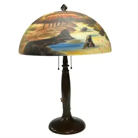
HANDEL Reverse Painted Landscape Table LampPremier Auction Galleries4.3(338)See Sold PriceMar 09, 2024
Jules Verne, Mirifiques Aventures de Maitre, Aux HarponsLion and Unicorn4.7(1.9k)See Sold PriceMar 03, 2024
Jules Verne, Mirifiques Aventures de Maitre, Aux HarponsLion and Unicorn4.7(1.9k)See Sold PriceMar 03, 2024
Robert de Vaugondy - Map of Canada - Mer de l' Ouest or Sea of the West and a Northwest PassageProverde Auctions4.3(3)See Sold PriceFeb 28, 2024