SoldGeological Survey of WyomingU.S. Geological Survey of Wyoming and Continguous Territory 1870. Hayden Government Printing Office 1872See Sold Price
SoldGeological Survey Montana, Wyoming by Hayden 1873Sixth Annual Report of the United States Geological Survey of The Territories, embracing portions of Montana, Idaho, Wyoming and Utah by F. V. Hayden. EX-LIBRARY stamping inside front covers, no otherSee Sold Price
SoldHayden Survey signed by Mormon leaderHeading: Author: Hayden, Ferdinand V. Title: Preliminary Report of the United States Geological Survey of Wyoming, and Portions of Contiguous Territories (Being a Second Annual Report of Progress,) CSee Sold Price
Geological/Geographical Survey..Wyoming and IdahoU.S. Geological and Geographical Survey... Wyoming and Idaho for the year 1878. Washington D.C. P.O.: 1883, 2 vols. Thick Small 4to.See Sold Price
Large geologic map of YellowstoneTitle: Yellowstone National Park and North Western Wyoming Author: U.S. Geological Survey Description: Color lithographed map. 89.5x66 cm. (35¼x26").Large map of the Yellowstone region from the U.S.See Sold Price
Map of Yellowtone Lake 1871Title: Yellowstone Lake Wyoming Territory Author: U.S. Geological Survey Description: Lithographed map. 37x38 cm. (14½x15").Map of Yellowstone Lake from the U.S. Geological and Geographical Survey ofSee Sold Price
SoldU.S. Geological and Geographical SurveyU.S. Geological and Geographical Survey of the Territories of Wyoming and Idaho 1878 (2 volumes) by F.V. Hayden. U.S. Government Printing Office 1883 VG condition. Provenance: Private collection, DaveSee Sold Price
SoldHayden Survey l & llU S Geological and Geographical Survey of the Territories of Wyoming and Idaho - 1878 - Part 1 and 2, by F V Hayden. Printed by the Government Printing Office 1883. Twelfth Annual Report. Important 2See Sold Price
SoldPart of Central Wyoming MapUS geological and geological survey of the territories, F.V. Hayden, US geologist in charge. 26.5x34.5"See Sold Price
Lot Of 4 Vintage Color Utah Maps:3 - Brigham City, Utah/Idaho c1958 & 1 - Salt Lake City, Utah/Wyoming c1960, U.S. Geological Society, Interior-Geological Survey, Washington, D.C. c1954 Condition Near Mint Size 34" x 22"See Sold Price
Sixth Annual Hayden Report 1872Heading: Author: Hayden, F[erdinand] V. Title: Sixth Annual Report on the United States Geological Survey of the Territories, Embracing Portions of Montana, Idaho, Wyoming, and Utah; Being a Report oSee Sold Price
Economic Map of Portions of Wyoming, Idaho and UtahTitle: Economic Map of Portions of Wyoming, Idaho and Utah Publication Date: 1879-04-01 Cartographer: HAYDEN, FERDINAND VANDIVEER Publisher: U.S. GEOLOGICAL AND GEOGRAPHICAL SURVEY OF THE TERRITORIESSee Sold Price
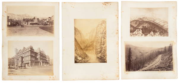
SoldF.V. Hayden 12th Annual Report Territories WY & IDFor your consideration is this F.V. Hayden 12th Annual Report of Geological and Geographical Survey of the Territories: A report of progress of the exploration in Wyoming and Idaho for the year 1878.See Sold Price
SoldHayden report of Yellowstone, etc., 1883Title: Twelfth Annual Report of the United States Geological and Geographical Survey of the Territories: A Report of Progress of the Exploration in Wyoming and Idaho for the Year 1878 Author: Hayden,See Sold Price
SoldHayden's reports on YellowstoneHeading: Author: Hayden, Ferdinand V. Title: Twelfth Annual Report of the United States Geological and Geographical Survey of the Territories: A Report of Progress of the Exploration in Wyoming and ISee Sold Price
SoldHayden's reports on YellowstoneTitle: Twelfth Annual Report of the United States Geological and Geographical Survey of the Territories: A Report of Progress of the Exploration in Wyoming and Idaho for the Year 1878 Author: Hayden,See Sold Price
Sold1883 12th Geological Report by Hayden (2 Vol)Twelfth Annual Report of the United States Geological and Geographical Survey of The Territories: A Report of Progress of the Exploration in Wyoming and Idaho (Yellowstone National Park) for the yearsSee Sold Price
PRESIDENT HAYES SIGNED 1870 GEOLOGICAL SURVEY OHIO:Geological Survey of Ohio, Report of Progress in 1870. Columbus, 1871. Signed by R. B. Hayes on title page. With letter dated 20 March 1872. Given to Prof. R. M. Eames by R. B. Hayes.See Sold Price
SoldGeological Survey of New Jersey Maps, 1868Geological Survey of New Jersey Maps, 1868. Is a series of loose maps of various geological maps throughout New Jersey. By George H Cook & John C Smock, Geologists and surveyed & drawn by G M Hopkins.See Sold Price
SoldGeological Survey of New Jersey Gasteropoda&CephalopodaGeological Survey of New Jersey Gasteropoda and Cephalopoda of the Raritan Clays and Greensand Marls of New Jersey by Robert P Whitfield. Published by John L Murphy, Trenton, 1892. Is in very good conSee Sold Price
SoldGeological Survey of NJ Brachiopoda & LamellibrachiataGeological Survey of New Jersey Brachiopoda and Lamellibranchiata of the Raritan Clays and Greensand Marls of New Jersey by Robert P Whitfield. Published by John L Murphy, Trenton, 1886. The front covSee Sold Price
SoldGeological Wyoming Fish FossilEocene Period, 58-36 millions years BP. A fossil fish of the genus Priscacara sp. encased in sedimentary rock from the Green River Formation, Wyoming. Stone, 1.6 kg, 27 cm. Acquired on the London artSee Sold Price
SoldUS Geological Survey Map of the United StatesVery large book of US maps, from the whole country. All color topographical maps, featuring quadrant sections. This book measures 28"x19", and has railroads indicated on the maps. These maps are detaiSee Sold Price
Natural History - Green River Fossil Fish GroupTimeLine Auctions Ltd.4.5(183)See Sold PriceMar 08, 2024
Natural History - Green River Fossil Fish GroupTimeLine Auctions Ltd.4.5(183)See Sold PriceMar 08, 2024
Nottingham.- Ordnance Survey Office (publisher) Collection 8 geological maps on the environs ofForum Auctions4.3(52)See Sold PriceFeb 29, 2024
Virginia and West Virginia Topography MapsRapid Estate Liquidators and Auction Gallery4.5(1.1k)See Sold PriceFeb 28, 2024


![Untitled. [Eastern U.S., Gulf of Mexico and Caribbean] (1 of 5)](https://p1.liveauctioneers.com/5584/319958/171812128_1_x.jpg?height=282&quality=70&version=1708466739)