Sold(2) 1819 & 1873 Maps of Wash. District of ColumbiaGroup of (2) maps of Washington, DC from 1819 and 1873: a) Plan of the city of Washington and territory of Columbia, engraved by W. & D. Lizars, Edin'r. Lizars, W. H. 1788-1859. (William Home), CREATESee Sold Price
Sold1 piece. Engraved Map. Plan of The City of Washin1 piece. Engraved Map. Plan of The City of Washington and Territory of Columbia." Edinburgh: W. & D. Lizars, [ca. 1850]. 13 1/2 x 13 1/2 inches (343 x 343 mm) - image size, wide margins but trimmed wiSee Sold Price
SoldPlan of the City of Washington in the Territory..[Washington, D.C./Andrew Ellicott]. Plan of the City of Washington in the Territory of Columbia ceded by the States of Virginia and Maryland to the United States of America, and by them established asSee Sold Price
SoldPlan Of The City Of Washington In The Territory...[Washington, D.C.]. Plan Of The City Of Washington In The Territory Of Columbia. Ceded by the States of Virginia and Maryland to the United States of America, and by them Established as the Seat of thSee Sold Price
SoldEllicott Map: Plan of the City of Washington. 1792[Washington, D.C.] Andrew Ellicott. Plan of the City of Washington in the Territory of Columbia ceded by the States of Virginia and Maryland to the United States of America, and by them established asSee Sold Price
SoldAndrew Ellicott, "Plan for Washington"-1880, MapAndrew Ellicott (American, 1754-1820); John Vallance (American, 1770-1823); James Thackara (American, 1767-1848). "Plan of the city of Washington in the territory of Columbia : ceded by the states ofSee Sold Price
SoldPlan Of The City Of Washington, [1796].[Washington, D.C.]. Plan Of The City Of Washington, In the Territory of Columbia, ceded by the States of Virginia and Maryland, to the United States of America, and by them established as the Seat ofSee Sold Price
SoldRussell's Plan of Washington 1795Title: Plan of the City of Washington, in the Territory of Columbia, Ceded by the States of Virginia and Maryland to the United States of America and by them Established as the Seat of their GovernmenSee Sold Price
Sold[Washington, D.C.]. Plan Of The City Of Washingto[Washington, D.C.]. Plan Of The City Of Washington, In The Territory Of Columbia, Ceded By The States Of Virginia And Maryland To The United States Of America, And By Them Established As The Seat Of TSee Sold Price
SoldPlan of the City of Washington... [1796].[Washington, D.C./Andrew Ellicott]. Plan of the CITY of Washington in the Territory of Columbia ceded by the States of VIRGINIA and MARYLAND to the United States of America and by them established asSee Sold Price
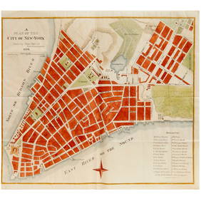
SoldMap of the City of Washington Map of the City of Washington Plan of the City of Washington in the Territory of Columbia, ceded by the States of Virginia and Maryland to the United States of America, and by them established as thSee Sold Price
MAPS IN BOOK - Washington, D.C.. RussellWashington, D.C.. John C. Russell, Plan of the City of Washington in the Territory of Columbia... [bound in] An Historical Geographical, Commercial, and Philosophical View of the American United StateSee Sold Price
Sold1798 map plan City of Washington1798 Map "Plan of the City of Washington". Published by John Stockdale 1798. Copper-engraved city plan, later hand-coloring. 6½x8½ .From Isaac Weld, Travels through the States of North America.See Sold Price
Water & Power Company Stocks and Bonds (7) [118784]Lot includes two bonds from General Water Works & Electric, (DE), 1929; and stocks from Fairhaven City Water & Power, Washington Territory, 1905; Elgin Power & Water Co., (UT), 1902; Peterson Heat, LiSee Sold Price
SoldCity Plan of Washington DC, 1885Map: City Plan of Washington DC Cartographer: Cpt. Greene Publishing: 1885 Size: 15.5 x 20 inches Colorful and unusual street map of Washington DC. It also shows the railroads and roads in the capitalSee Sold Price
SoldAmericas.- Weld (Isaac) Plan of the City of Washington,NO RESERVE Americas.- [Weld (Isaac)] Plan of the City of Washington, Carl Jattnig's reduced version of the 1792 L'Enfant-Ellicott plan of the city, based on Stockdale's engraving of 1798, engraving onSee Sold Price
SoldIsaac Weld. Plan of the City of Washington(Irish, 1774-1856). Published by J. Stockdale, Piccadilly 16th Sep 1798, 6 1/2 x 8 1/4 in., framedSee Sold Price
SoldCity Plan of Washington, DC, 1885Original engraving by Captain Greene, 1885. Map shows street plans and railroad systems. Dimensions: 15.5" L x 20" WSee Sold Price
SoldMap for the Plan of the City of Washington. c.1799A map for the "Plan of the City of Washington". In the lower margin: “Published by J. Stockdale, Picadilly 16th Sepr. 1798.” The map appeared in Isaac Weld’s “Travels through the States of NorSee Sold Price
SoldJOHN REID - PLAN OF THE CITY OF WASHINGTON, 1795 -John Reid - Plan Of The City Of Washington, 1795 - Giclée On Canvas - 30 X 23 In. - A Giclée Print Is The Highest Quality Print Available Today. Because There Is No Visible Dot Screen Pattern, The RSee Sold Price
SoldJOHN REID -PLAN OF THE CITY OF WASHINGTON, 1795 -John Reid -plan Of The City Of Washington, 1795 - Giclée On Canvas -44 X 33 3/4 In. - A Giclée Print Is The Highest Quality Print Available Today. Because There Is No Visible Dot Screen Pattern, TheSee Sold Price
SoldPLAN OF THE CITY OF WASHINGTON Thackara & Valance Antique PrintLarge framed antique print of the original "Plan of the City of Washington" 1792 Thackara & Valance engraving.See Sold Price
SoldJohn Stockdale, Plan of the City of WashingtonJohn Stockdale (British, 1750-1814) paper and ink. It is captioned 'Plan of the City of Washington, published in Piccadilly, 16 September 1794.' Dimensions: sight size-7 3/4 inches tall X 9 3/4 inchesSee Sold Price
Soldc. 1800 “Plan of the City of Washington” JattnigFederal Period c. 1800 Early Printed “Plan of the City of Washington” c. 1800 Federal Period, “Plan of the City of Washington,” Engraving by Carl Jattnig, Berlin, measuring 9.75” x 8”, ChoSee Sold Price
Washington The City Beautiful circa 1920North American Artifact Auctions4.6(182)See Sold PriceApr 20, 2024
JACKSON, Samuel L., ed. Jackson's International Almanac: A Pocket Encyclopedia of the Negro. [NewFreeman's | Hindman4.4(1.6k)See Sold PriceFeb 27, 2024
[ENSLAVEMENT & ABOLITION]. A group of 3 Virginia documents listing property including enslavedFreeman's | Hindman4.4(1.6k)See Sold PriceFeb 27, 2024
Mitchell - Map of the City of Washington (Washington, DC)Trillium Antique Prints & Rare Books4.5(30)See Sold PriceFeb 24, 2024
COLONIAL TOGO & BENIN (Dahomey). Porto Novo & Lomé city ville plans 1929 mapJasper524.5(9.8k)See Sold PriceFeb 28, 2024
FRENCH SUDAN (Now Mali). Soudan Français. Bamako city plan de la ville 1929 mapJasper524.5(9.8k)See Sold PriceFeb 28, 2024
FRENCH COLONIAL GUINEA. Guinee Française. Conakry city town ville plan 1931 mapJasper524.5(9.8k)See Sold PriceFeb 28, 2024
FRENCH SUDAN (Now Mali). Soudan Français. Bamako city plan de la ville 1938 mapJasper524.5(9.8k)See Sold PriceFeb 28, 2024
FRENCH SUDAN (Now Mali). Soudan Français. Bamako city plan de la ville 1931 mapJasper524.5(9.8k)See Sold PriceFeb 28, 2024
COLONIAL TOGO & BENIN (Dahomey). Porto Novo & Lomé city ville plans 1931 mapJasper524.5(9.8k)See Sold PriceFeb 28, 2024
COLONIAL TOGO & BENIN (Dahomey). Porto Novo & Lomé city ville plans 1938 mapJasper524.5(9.8k)See Sold PriceFeb 28, 2024
[Constructivism]. The general plan of reconstruction of Moscow. - Moscow: Moscow Worker, 1936. -ARTMAXIMUM4.3(4)See Sold PriceMar 14, 2024
C.1888 Tacoma Boudoir Card Waterfront by RutterGrant Zahajko Auctions, LLC4.8(1k)See Sold PriceMar 06, 2024
[Washington Territory, Lumber] Letterhead (7)Grant Zahajko Auctions, LLC4.8(1k)See Sold PriceMar 06, 2024


![Plan Of The City Of Washington, [1796]. (1 of 1)](https://p1.liveauctioneers.com/179/12368/3397017_1_x.jpg?height=282&quality=70&version=1175725014)

![[Washington, D.C.]. Plan Of The City Of Washingto (1 of 1)](https://p1.liveauctioneers.com/179/2417/1045281_1_x.jpg?height=282&quality=70)
![Plan of the City of Washington... [1796]. (1 of 10)](https://p1.liveauctioneers.com/179/38978/16707132_1_x.jpg?height=282&quality=70&version=1364397316)


![Water & Power Company Stocks and Bonds (7) [118784] (1 of 1)](https://p1.liveauctioneers.com/2699/193409/97516663_1_x.jpg?height=282&quality=70&version=1612303038)


![[ENSLAVEMENT & ABOLITION]. A group of 3 Virginia documents listing property including enslaved (1 of 2)](https://p1.liveauctioneers.com/197/319238/171468033_1_x.jpg?height=282&quality=70&version=1707520367)


![[Constructivism]. The general plan of reconstruction of Moscow. - Moscow: Moscow Worker, 1936. - (1 of 6)](https://p1.liveauctioneers.com/6171/320219/172084257_1_x.jpg?height=282&quality=70&version=1708525949)

![[Washington Territory, Lumber] Letterhead (7) (1 of 5)](https://p1.liveauctioneers.com/5755/320282/172114106_1_x.jpg?height=282&quality=70&version=1708463029)


