SoldFortificazioni - De Fer, Nicolas Introduction a la FortParigi, chez l’Autheur, 1705. In 2° oblungo. 183 fogli, di cui 8 di testo incluso il frontespizio e i restanti 175 con incisioni su rame raffiguranti piante e vedute di città, bruniture e marginalSee Sold Price
Fortificazioni - De Fer, Nicolas. Introduction a lFortificazioni - De Fer, Nicolas. Introduction a la Fortification.Parigi, chez l'Autheur, 1705. In 2° oblungo. 183 fogli, di cui 8 di testo incluso il frontespizio e i restanti 175 con inSee Sold Price
Fortificazioni - De Fer, Nicolas. Introduction a lFortificazioni - De Fer, Nicolas. Introduction a la Fortification.Parigi, chez l'Autheur, 1705. In 2° oblungo. 183 fogli, di cui 8 di testo incluso il frontespizio e i restanti 175 con inSee Sold Price
De Fer NicolasDe Fer Nicolas, Introduction a la fortification dediée a monseigneur le duc de Bourgogne. Par son tres humble seruiteur de Fer. Paris: chez l'auteur dans l'isle du palais sur le quay de l'orologe a lSee Sold Price
SoldDe Fer NicolasDe Fer Nicolas, Introduction à la fortification. Paris: Chez l'Auteur, s.d. [ma 1705]. In-folio oblungo (mm 273x400). Carte [188] così composte: 1 frontespizio figurato con due scene di battagSee Sold Price
Introduction a la Geographie 1717Title: Introduction a la Geographie: Avec une Description Historique sur Touttes les Parties de la Terre Author: De Fer, Nicolas Description: [2], 197, [9] pp. With 5 (of 6) folding copper-engraved plSee Sold Price
Introduction a la Geographie 1717Title: Introduction a la Geographie: Avec une Description Historique sur Touttes les Parties de la Terre Author: De Fer, Nicolas Description: [2], 197, [9] pp. With 5 (of 6) folding copper-engraved plSee Sold Price
SoldDe Fer geography with striking mapsHeading: Author: Fer, Nicolas de Title: Introduction a la Geographie avec une Description Historique sur touttes les parties de la Terre Place Published: Paris Publisher:Chez le Sr. Danet Date PSee Sold Price
SoldIntroduction à la Geographie avec une DescrAuthor: Fer, Nicolas de [2], 197, [9] pp. With 6 folding copper-engraved plates of maps. (8vo) 7¾x4¾, period calf, spine tooled in gilt, raised bands, morocco lettering pieces, later endpapers. SecoSee Sold Price
Introduction a la Geographie 1717Title: Introduction a la Geographie: Avec une Description Historique sur Touttes les Parties de la Terre Author: Fer, Nicolas de Description: [2], 197, [9] pp. With 5 (of 6) folding copper-engraved plSee Sold Price
1717 geography by De Fer with 6 mapsTitle: Introduction a la Geographie avec une Description Historique sur touttes les parties de la Terre Author: Fer, Nicolas de Description: [2], 197, [9] pp. With 6 folding copper-engraved plates ofSee Sold Price
FontarabieTitle: Fontarabie Cartographer: FER, NICOLAS DE (1646-1720) Publisher: N DE FER Size: 9Height - 11.5Width "Port de mer sur l'ocean et ville fort de Espagne... From De Fer's "Introd. a la fortificationSee Sold Price
Calais.Publication Date: 1693 Title: Calais. Cartographer: FER, NICOLAS DE (1646-1720) Publisher: N DE FER Height: 7.75 Width: 10.8 "Ville Fort de Picardie..." L. Scherm, Fec. From De Fer's "Introd. a la forSee Sold Price
Calais.Publication Date: 1693 Title: Calais. Cartographer: FER, NICOLAS DE (1646-1720) Publisher: N DE FER Height: 7.75 Width: 10.8 "Ville Fort de Picardie..." L. Scherm, Fec. From De Fer's "Introd. a la forSee Sold Price
De Fer: Antique Town Plans of Marseille, 1705Title: Lentreé du Port de Marseille, et le Plan de la Citadelle et du Fort de St Jean.... Map maker: Nicolas de Fer Place and Year: Paris, 1705 Dimensions: Plan 1: 28 x 36 cm (11 x 14.2 in); Plan 2:See Sold Price
SoldMiddle East.- de Fer (Nicolas) - La Perse, La GeorgiePersia and the Middle East including the eastern Mediterranean and north Egypt, engraved map with original hand-colouring in outline. 230 x 335mm., Paris, 1705; with a small mixed group of 19th centurSee Sold Price
SoldDe Fer (Nicolas) La Grece ou La Partie MeridionaleDe Fer (Nicolas) La Grece ou La Partie Meridionale De La Turquie En Europe ...,large rare map of Greece, with deocrative title cartouche lower left, engraving with hand-colouring, 490 x 690mm.See Sold Price
Soldde Fer, Nicolas. La Partie Orientale De L'Asie(Paris: Chez L'Auteur, 1705), copperplate engraving of China and Japan with very conservative use of outline color.. Presented in lightly gilt wooden frame. DOA 16.25 x 20 in. Additional high-resolutSee Sold Price
De Fer, Nicolas Veue de la ville et du port deDe Fer, Nicolas Konstantinopel Veue de la ville et du port de Constantinople. Kolorierte Kupferstichkarte von N. de Fer aus Atlas curieux. Paris, 1705. Blattgröße ca. 27 x 39 cm. Dekorative AnsichtSee Sold Price
SoldFER, NICOLAS de. La Grande Riviere de Canada aFER, NICOLAS de. La Grande Riviere de Canada appellee par les Europeens de St. Laurens. Large engraved 2-sheet map joined, 605x960 mm overall; some toning, considerably browned along one fold, minor sSee Sold Price
SoldFER (Nicolas de)FER (Nicolas de) La Mer Méditerranée et les costes des estats qui la borne. Sans lieu, 1709. 36,5 x 76,5 cm. Superbe carte très détaillée des côtes et ports de la Méditerranée. Monté sur cartSee Sold Price
Sold[MAP]. FER. La Californie ou Nouvelle Caroline. 1720293. [MAP]. FER, Nicolas de. La Californie ou Nouvelle Caroline. Teatro de los trabajos, apostolicos de la Compa. de Jesus en la America, Septe. Dressée sur celle que le Viceroy de la NouvelleSee Sold Price
SoldFer, N. de: Introduction à la fortificationFer, (N.) de. Introduction à la fortification. Gestoch. Titel und 192 gestochene Pläne und Ansichten (darunter einige gestoch. Texte). 28 x 41 cm (Blattgröße). Marmor. Lederband d. Z. (etwas berieSee Sold Price
SoldFer, N. de: Introduction à la fortificFer, (N.) de. Introduction à la fortification. Gestoch. Titel und 128 gestochene Pläne und Ansichten (davon 2 gefaltete). 27,5 x 41 cm (Blattgröße). Ungebunden. Lose Blatt. (Paris, de Fer, 1705 unSee Sold Price
Archaeological Books - Déchelette - Manuel D'Archeologie - 3 VolumesTimeLine Auctions Ltd.4.6(183)See Sold PriceMar 06, 2024
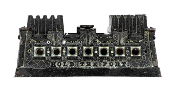
Hold the Fort - Five Holes - Mechanical BankThe RSL Auction Company4.6(240)See Sold PriceMar 09, 2024
JULIEN LACAZE (1886-1971) LA CÔTE BRETONNE / CHEMINS DE FER DE L'ÉTAT. 1914.Swann Auction Galleries4.4(70)See Sold PriceFeb 29, 2024
JEAN-PAUL RIOPELLE (Montreal, Canada,1923-2002). "Force des forêts", from the folder "Alechinsky,Setdart Auction House4(23)See Sold PriceMar 05, 2024
1764 Bellin Map of St. Kitts -- Carte de l'Isle St. ChristopheJasper524.5(9.9k)See Sold PriceFeb 27, 2024
1764 Bellin Map of Southern Portion of Martinique -- Partie Meridionale de la MartiniqueJasper524.5(9.9k)See Sold PriceFeb 27, 2024
1845 Delisle/Bauche Map of Martinique -- Carte de l'Isle de la Martinique Colonie Francoise de l'uneJasper524.5(9.9k)See Sold PriceFeb 27, 2024
1764 Bellin Map of Fort Louis Area of Guadeloupe -- Environs du Fort Louis de la GuadeloupeJasper524.5(9.9k)See Sold PriceFeb 27, 2024
Guinea-Bissau. Cacheu town & Fortaleza de São José da Amura. SCHLEY 1747 printJasper524.5(9.9k)See Sold PriceFeb 28, 2024
Guinea-Bissau. View of Cacheu town & Fortaleza de São José da Amura 1746 printJasper524.5(9.9k)See Sold PriceFeb 28, 2024


![[MAP]. FER. La Californie ou Nouvelle Caroline. 1720 (1 of 6)](https://p1.liveauctioneers.com/514/38480/16487190_1_x.jpg?height=282&quality=70&version=1363614971)