SoldA CHART AND VIEW OF PITCAIRNS ISLAND[MAPS] c. 1781, Map "A Chart and Views of Pitcairns Island". Overall size 9" x 15.25" (the actual printed area is smaller). Published in London by Alexander Hogg for use as an illustration in a book aSee Sold Price
Soldc. 1781, Map: Captain Cook VoyagesMapsc. 1781, Map “A Chart and Views of Pitcairns Island", Extremely Fine. Overall size 9" x 15.25" (the actual printed area is smaller). Published in London by Alexander Hogg for use as an illusSee Sold Price
Soldc. 1781, Map: Captain Cook VoyagesMapsc. 1781, Map “A Chart and Views of Pitcairns Island", Extremely Fine. Overall size 9" x 15.25" (the actual printed area is smaller). Published in London by Alexander Hogg for use as an illusSee Sold Price
Soldc. 1781, Map-Captain Cook Voyagesc. 1781, Map “A Chart and Views of Pitcairns Island", Extremely Fine. Overall size 9" x 15.25" (the actual printed area is smaller). Published in London by Alexander Hogg for use as an illustratSee Sold Price
Soldc. 1781, Map: Captain Cook VoyagesMapsc. 1781, Map “A Chart and Views of Pitcairns Island", Extremely Fine. Overall size 9" x 15.25" (the actual printed area is smaller). Published in London by Alexander Hogg for use as an illusSee Sold Price
Three views of the Admiralty IslesPublished by Alexander Hogg, London, 1784 Copper-plate engraving 22 x 35 cm (8 1/2 x 14 in) This fine original antique nautical chart and coastal view of the Admiralty Islands, off the coast of northSee Sold Price
Fiji Islands – Pacific Ocean British Admiralty ChartVery detailed, unused and authentic chart of Ngau Island and Mambulitha Reef in the Fiji or Viti Island Group. With beautiful view on the island. Authentic sea chart, no modern copy. On thick paper, fSee Sold Price
West-Indies – St. Vincent and the Grenadines, BritishImpressive and detailed, unused chart of St. Vincent with beautiful land view of the island. The first surveys are from 1863 by Staff Commander J. Parsons. With tidal information. Authentic, very detaSee Sold Price
SoldMadeira.- [Johnston (William)] [Geo-Hydrographic SurveyMadeira.- [Johnston (William)] [Geo-Hydrographic Survey of the Isle of Madeira with the Dezertas and Porto Santo Islands geometrically taken in the year 1788], one section only, with chart with view oSee Sold Price
Sold1775 Plan of the Town & Chart of the Harbour of BostonA Plan of the Town and Chart of the Harbour of Boston Exhibiting a View of the Islands, Castle Forts and Entrances into the Said Harbour, printed at London, 1775 for Gentleman's Magazine. Mild creasinSee Sold Price
Sold(Maps and Charts, Boston, Revolutionary War), A Pl(Maps and Charts, Boston, Revolutionary War), A Plan of the Town and Chart of the Harbour of Boston, exhibiting a View of the Islands Castle Forts and Entrances into the said Harbour, [n.p., c. 1776],See Sold Price
Sold'A VIEW OF THE ISLANDS OF ICE AS SEEN IN COOK’S SECOND 'A VIEW OF THE ISLANDS OF ICE AS SEEN IN COOK’S SECOND VOYAGE ON JANY. 9. 1773' hand-coloured engraving laid on card; together with 'chart of Cooks River in the N.W. part of America', hand-colouredSee Sold Price
SoldFour 18th Century Maps of America.Four 18th Century Maps of America. A PLAN of the TOWN AND CHART of the HARBOUR of BOSTON Exhibiting a View of the Islands Castle Forts and Entrance into the said Harbour, 1775. Sight ht. 11 1/4, wd. 1See Sold Price
SoldBoston in early days of Revolution Feb. 1775Title: A Plan of the Town and Chart of the Harbour of Boston Exhibiting a View of the Islands Castle Forts and Entrances into the Said Harbour Author: Gentleman's Magazine Description: Copper-engravedSee Sold Price
South Pacific – Fiji Islands, Easren Group BritishVery nice engraved and detailed sea chart of the Fiji Islands with land view of the Nasavusavu Bay. The first surveys are from 1878 to 1881 by Captain W.U. Moore. Tidal information is mentioned. AutheSee Sold Price
SoldDavid Porter A Voyage In The South Seas 1823Title: A Voyage In The South Seas, In The Years 1812, 1813 and 1814. With Particular Details Of The Gallipagos and Washington Islands. Author: Porter, David Description: [i], 126. 4 views and charts,See Sold Price
SoldKeate, An Account of the Pelew IslandsKeate (George) An Account of the Pelew Islands, second edition, engraved frontispiece and 17 plates, including a large folding chart and a folding view, some foxing and offsetting, contemporaSee Sold Price
SoldKeate (George) An Account of the Pelew IslandsKeate (George) An Account of the Pelew Islands,first edition, engraved frontispiece and 17 plates (large folding chart and a folding view), title and some other pp. slightly offset, folding viSee Sold Price
SoldWest-Indies – Dominica Island, Roseau and PrinceDetailed, unused chart of Prince Rupert and Roseau on the coast of Dominica Island with beautiful land view of Goodwill and Barners Block. The first surveys are from 1872 by Staff Commander G. StanleySee Sold Price
SoldNorie (J.W.) The Gulf of PersiaNorie (J.W.) The Gulf of Persia,coastal chart with rhum lines, coastal recognition views, and 5 inset charts of bays and islands, including Muscat and the mouth of the Euphrates, engraved charSee Sold Price
New Hebrides - South Pacific Ocean British AdmiraltyTwo hardly used, detailed sea charts of the New Hebrides with Anetyum Island, Torres Island and many others islands, with a beautiful engraved view of the Bastion Rock on Maewo Island. The first surveSee Sold Price
SoldScandinavia.- Nordenankar (Johan) - Pass Charta öfverlarge chart of the western Baltic islands, with the coasts of Jutland, Schleswig, Holstein, southern Sweden and Pomerania, with 2 inset charts and a panel of coastal recognition views, decorative titlSee Sold Price
Mayo coast nautical sea chart Achill Island CorraunTITLE/CONTENT OF MAP: 'Ireland - West Coast - Achill Head to Roonagh Head' The top image on the right hand side shows the entire map. To view a close up of the map showing the level of printed detail,See Sold Price
The Antilles or Charibbee or Caribs IslandsTITLE/CONTENT OF MAP: 'A chart of the Antilles or Charibbee or Caribs Islands with The Virgin Isles by L.S. De La Rochette' The top image on the right hand side shows the entire map. To view a close uSee Sold Price
CHART "LONG ISLAND SOUND FROM NEW YORK TO MONTOCK POINT ..." New York, 1830 21" x 77" sight. FramedEldred's4.7(423)See Sold PriceFeb 27, 2024
CHART "SOUTHERN COAST OF LONG ISLAND FROM MONTAUK POINT TO EAST HAMPTON" Circa 1877 11.25" x 22.75"Eldred's4.7(423)See Sold PriceFeb 27, 2024
20thC. American Two-Dimensional Embroidery Signed, Long Island Coastal View with ShipDonny Malone Auctions4.5(1.8k)See Sold PriceMar 04, 2024
1764 Bellin Map of Lesser Antilles Northern Portion -- Petites Antilles ou Isles du Vent 3e. Partie.Jasper524.5(9.9k)See Sold PriceFeb 27, 2024
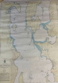
CHART: U.S LAKE SURVEYS/ LAKE CHAMPLAIN/ CUMBERLAND HEAD, NY and SAVAGE ISLAND, VT. TO FOUR BROTHERSChurchill Galleries3.7(217)See Sold PriceFeb 26, 2024
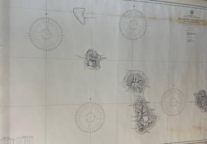
CHART: South Pacific Ocean / SOCIETY ISLANDS - WESTERN GROUP/ HUAHINE TO MAUPITI With theChurchill Galleries3.7(217)See Sold PriceFeb 26, 2024
AN EARLY 19TH CENTURY CHAMBERLAINS WORCESTER PORCELAIN CUP AND SAUCER painted with a view of DudmastHannam's Auctioneers Ltd4.3(399)See Sold PriceFeb 27, 2024
Jacques Nicolas Bellin - Antique Map - Vue de la Rade de Tiniam, double antique coast view of theProverde Auctions4.3(3)See Sold PriceFeb 28, 2024


![Madeira.- [Johnston (William)] [Geo-Hydrographic Survey (1 of 1)](https://p1.liveauctioneers.com/5458/147572/74578981_1_x.jpg?height=282&quality=70&version=1565275641)