SoldJansson (Jan) Hellas seu Græcia SophianiJansson (Jan) Hellas seu Græcia Sophianiclassical Greece, after Ortelius, with figurative cartouche of warriors in armour, the scale supported by putti, engraved map, 375 x 500mm., some wear oSee Sold Price
SoldJan Jansson. Greece mapJan Jansson. Hellas seu Graecia Sophiani, hand coloured engraved map of Greece, c. 1658, 375 x 510mm (visible)See Sold Price
SoldMAP - Greece & Western Turkey. JanssonGreece & Western Turkey. Jan Jansson, Hellas seu Graecia Sophiani, 1741 (published). Hand Color. This uncommon map is Jansson's copy of Hondius' map, which in turn was based on Abraham Ortelius' map.See Sold Price
SoldHoly Land.- Jansson (Jan) Judaeae seu Terrae Israelis,Holy Land.- Jansson (Jan) Judaeae seu Terrae Israelis, map showing the divided kingdoms of Judea and Israel, with large title cartouche supported by the figures of Moses and Aaron in the upper left coSee Sold Price
SoldJansson (Jan) - Iudææ Seu Terræ Israelis Tabulathe Holy Land with title cartouche supported by the figures of Moses and Aaron, rustic figures carrying a bunch of giant grapes, lower right, engraved map, 355 x 480mm., blank verso, repaired split onSee Sold Price
SoldGriechenland (Janssonius): Hellas seu GraeciaGriechenland. Hellas seu Graecia Sophiani. Kupferstich mit zeitgenöss. kolorierter figürlicher Kartusche und Meilenmesser sowie mit zeitgenöss. Grenzkolorit. 36,6 x 50 cm. Aus einem Atlas des JohanSee Sold Price
MAP - Holy Land. JanssonHoly Land. Jan Jansson, Iudaeae seu Terrae Israelis Tabula Geographica; in qua Locorum in Veteri et Novo Testamento Celebratissimorum Situs Accurate Descripti..., 1684 (circa). Hand Color. Taken fromSee Sold Price
Sold1650 Insularum Archipelagi Septentrion Alis Seu MarisBy: Jan JanssonDate: 1650 (circa) AmsterdamDimensions: 18.75 x 22.25 inches (48 cm x 57 cm)This authentic antique hand-colored map by Jan Jansson depicts the Northern Archipelago in Greece with the AeSee Sold Price
SoldMap of the Holy Land. Tilemanno – Jan Jansson. TheIudaea seu Terrae Israelis Tabula geographica…arte facta a Tilemano Stella Sigenensi. Map of the Holy Land divided between the kingdoms of Judea and Israel. By Tilemanno Stella. Colored engraving, vSee Sold Price
1650 Insularum Archipelagi Septentrion Alis Seu MarisBy: Jan Jansson Date: 1650 (circa) Amsterdam Dimensions: 18.75 x 22.25 inches (48 cm x 57 cm) This authentic antique hand-colored map by Jan Jansson depicts the Northern Archipelago in Greece with theSee Sold Price
SoldMap or Table of Nautical WindsTabula Anemographica seu Pyxis Nautica Ventorum nomina sex linguis repraesentans. Jansson, Joan (Jan), Amsterdam, ca 1650. Plate approx. 17.25 x 21.6 in. (44 x 55cm). Before magnetic compasses, navigSee Sold Price
SoldJANSSON, Jan (1588-1664). Insulae Americanae in OceanoJANSSON, Jan (1588-1664). Insulae Americanae in Oceano Septentrionali cum Terris Adjacentibus. [Amsterdam, ca 1640]. Engraved map of the West Indies with hand-coloring, Dutch text on verso, sheet 19 xSee Sold Price
SoldJansson (Jan) - Virginiæ partis australis, etfrom Le Nouveau Theatre de la Monde, the eastern seaboard of North America from Chesapeake Bay in the north east to northern Florida in the south west, containing the arms of Britain and France to indSee Sold Price
SoldFrance.- Jansson (Jan) Nova Et Accurat DescriptioNO RESERVE France.- Jansson (Jan) Nova Et Accurat Descriptio Delphinatus Vulgo Dauphine, detailed map of central France, specifically the region around Grenoble and Gap, engraving with original outlinSee Sold Price
SoldJANSSON, JAN. Imperii Sinarum Nova Descriptio.(MAP) JANSSON, JAN Imperii Sinarum nova descriptio. (Amsterdam, c. 1664). Engraved map with hand-coloring of China, Korea and the islands of Formosa and Hainan. With decorative cartouche surrounded bySee Sold Price
Jansson (Jan) - Virginiæ partis australis, etfrom Le Nouveau Theatre de la Monde, the eastern seaboard of North America from Chesapeake Bay in the north east to northern Florida in the south west, containing the arms of Britain and France to indSee Sold Price
SoldJansson (Jan) - [Atlas Novus: Germany],single vol. lacking title, 106 mostly regional maps of Germany and northern Europe, but also including a general map of Germany, and classical maps of both Germany and Scandinavia, and several city plSee Sold Price
SoldPakistan, Afghanistan & Northern India.- Jansson (Jan)Pakistan, Afghanistan & Northern India.- Jansson (Jan) Magni Mogolis Imperium, map of the Empire of the Great Mogul in northern India including the region from Iran to Burma, decorated with title in tSee Sold Price
Sold(MAP) JANSSON, JAN. Buckingamiae Comitatus cum(MAP) JANSSON, JAN Buckingamiae Comitatus cum Bedfordiensi; vulgo Buckingamshire and Bedfordshire. Amsterdam, ca. 1645. Double-page engraved map hand-colored in outline. With decorative cartouche andSee Sold Price
Jansson (Jan) - Virginiæ partis australis, et Floridæfrom Le Nouveau Theatre de la Monde, the eastern seaboard of North America from Chesapeake Bay in the north east to northern Florida in the south west, containing the arms of Britain and France to indSee Sold Price
SoldJansson (Jan) Arabiae Felicis, Petraeae et Deserte,Jansson (Jan) Arabiae Felicis, Petraeae et Deserte, engraved map, outlined in colour, decorative cartouches depicting men with turbans and 4 cherubs, embellished with ships, camels, elephants, lionSee Sold Price
SoldJansson, Jan. Natolia, quae olim Asia MinorJansson, Jan. Natolia, quae olim Asia MinorAmsterdam, circa 1650), copperplate engraving with outline color, depicting Turkey, Cyprus and parts of the Levant, Spanish text en verso. Behind mat in woodSee Sold Price
SoldJansson, Jan. Insulae Americanae in Oceano...cum Terris adiacentibus (Amsterdam, circa 1640), copperplate engraving with outline color, German text en verso, the chart depicts the Caribbean and adjacent regions. Presented behind mat in woodenSee Sold Price
SoldJansson, Jan. Cyprus. Insula laeta choris, blandorum(Amsterdam, circa 1650), copperplate engraving, blank verso. Presented in a carved wooden frame. DOA 22.5 x 27.65 in.; SS 14 5/8 x 19.75 in. A Single-Owner Collection of Cypriot History & Culture fromSee Sold Price
Follower of JAN VAN EYCK (1390-1441) . Flemish school, 18th-19th century. "Virgin". Oil on canvas.Setdart Auction House4.1(22)See Sold PriceFeb 28, 2024
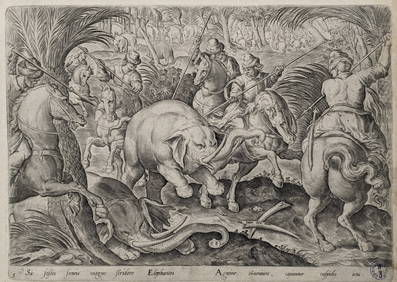
Philip Galle. 5 engravings. Hunting and fishing scenes. 4 from "Hunting Parties" after Jan StradanusTremont Auctions4.6(293)See Sold PriceFeb 25, 2024
Jean-Pierre (Jan Piotr) Norblin de La Gourdaine. 18th/19th century assembled album of etchings. ManyTremont Auctions4.6(293)See Sold PriceFeb 25, 2024
Attributed to Johannes (Jan) Tielius (Netherlands/France 1660-1719)Nadeau's Auction Gallery4.7(401)See Sold PriceFeb 24, 2024
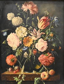
After Jan Brueghel The Elder (Belgian 1568-1625)Nadeau's Auction Gallery4.7(401)See Sold PriceFeb 24, 2024
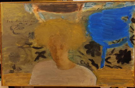
Jan Rauchwerger O/C Galit w Blue Hair Shades of FeelingHeritage Gallery Auctions4.4(56)See Sold PriceMar 10, 2024
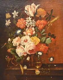
ATTRIBUTED TO JAN VAN HUYSUM (DUTCH), LATE 15-EARLY 16C OIL ON CANVAS, "STAG HUNT", LIGHT CRAZINGTHOS. CORNELL GALLERIES, LTD./CORNELL AUCTIONS, OBJECTS, AND TRADE4.5(313)See Sold PriceFeb 24, 2024
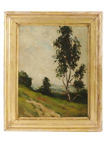
POLISH LANDSCAPE PAINTING BY JAN STANISLAWSKI SIGNEDAntique Arena Inc.4.5(852)See Sold PriceMar 02, 2024


![Jansson (Jan) - [Atlas Novus: Germany], (1 of 1)](https://p1.liveauctioneers.com/410/80717/41962763_1_x.jpg?height=282&quality=70&version=1445353131)