Sold(3) Westermann's Historical Maps Of EuropeThree Westermann 's Classical & Historical Map Series, published by Rand McNally, cloth on two wooden dowels, to include an 1190 map at the time of the Crusades, of Europe & Western Asia, a Medieval CSee Sold Price
MAPS Three European MapsMAPS Three European Maps1734. 3 historical maps of the ancient world from Justinus Explicatus.... The Meditterannean, Asia Minor and Western Europe mainly. Largest measures (215 x 355 mm). ConSee Sold Price
AMOS DOOLITTLE ENGRAVING OF EUROPEAMOS DOOLITTLE ENGRAVING OF EUROPE Engraved map of Europe, 9 3/4" x 8 1/2", executed by American engraver AMOS DOOLITTLE (1754-1832), and marked: "Engraved by A. Doolittle N.E.", and also: "PublishedSee Sold Price
AMOS DOOLITTLE ENGRAVING OF EUROPEAMOS DOOLITTLE ENGRAVING OF EUROPE Engraved map of Europe, 9 3/4" x 8 1/2", executed by American engraver AMOS DOOLITTLE (1754-1832), and marked: "Engraved by A. Doolittle N.E.", and also: "PublishedSee Sold Price
SoldEMERGENCY/ESCAPE SILK MAP OF CENTRAL EUROPEWehrmacht issue 1: 1,000,000 scale map, 33 3/4" x 31", depicting northern Germany, "Protectorate" (Bohemia & Moravia)", northern Slovakia, Poland and Northern Hungary on one side, and Croatia, MonteneSee Sold Price
SoldGerman WWII Period East-Europe + Westasia MapGerman foldable map of WWII period of Eastern Europe and West Asia "OST - EUROPE U. VORDER ASIEN" published by GOTHA JUSTUS PERTHES publishing house on a scale of 1: 3 000 000. Dimensions 82 x 93 cm.See Sold Price
15 ANTIQUARIAN HISTORICAL THEME BOOKS15 ANTIQUARIAN HISTORICAL THEME BOOKS: 1)7 Volumes History of Painting, Haldane Macfall, no date, DD Nickerson, missing Vol. 3. 2) View of the State of Europe in the Middle Ages, Henry Hallam, 1842, HSee Sold Price
SoldGoldsmith 1842 Group of 3 Maps. Europe, Asia, AfricaSteel Engraved Maps Published 1842, London for "Goldsmith's Grammar of Geography" by W. S. Kenny and the Rev. Goldsmith. Folds as issued. Paper Size: 7.5 x 6 inch (19 x 15cm) One with minor toning. TiSee Sold Price
SoldDelamarche, Felix 1829 Lot 3 Maps. Europe, Roman Empire"L'Europe avant l'Invasion des Barbares" "L'Europe divisee en ses Differens etats Sous Charlemagne" and "Imperii Roman Tabula" Copper Engraved Maps Published 1829, Paris for "Atlas de La Geographie...See Sold Price
SoldDelamarche, Felix 1829 Lot of 3 Maps. Europe & Germany"L'Europe a l'Epoque du demembrement de l'Empire de Charlemagne" "L'Europe avan l'Invasion des Barbares" and "Germania Antiqua et regiones Danubium" Copper Engraved Maps Published 1829, Paris for "AtlSee Sold Price
Lot 3 handkolorierte, historische Landkarten / Lot of 3Lot 3 handkolorierte, historische Landkarten / Lot of 3 Historical Maps, 18. Jh. 1x Landgraviat de Hesse, 1x Terre du Landgrave de Hesse Darmstatt (wohl aus einem gebundenen Werk stammend), Maße 33,5See Sold Price
SoldGrp: 3 Maps Eastern Europe Ukraine Romania BlaeuGroup of three maps of Eastern Europe. Includes one map of Walachia, Serbia, Bulgaria, and Romania by Willem Janszoon Blaeu (1571-1638); one map of Slovenia, Croatia, and Bosnia by Blaeu after GerarduSee Sold Price
SoldGrp: 3 Maps of EuropeGroup of three maps of Europe. Includes one hand colored map of the Netherlands by Herman Moll (1654-1732), "A New Map of the United Provinces of Netherlands &c." London: Herman Moll, ca. 1701; one DuSee Sold Price
Sold3 FRAMED HISTORICAL MAPS -ESQUIMAUX CHARTS - 1822COPIES OF CHARTS 1, 2 AND 3, "DRAWN BY ILIGLIUK AT WINTER ISLAND - THE ORIGINAL IN THE POSSESSION OF CAPTAIN LYON" 26" X 10"See Sold Price
SoldDelamarche, Felix 1829 Group of 3 Maps of EuropeEurope at the time of the Charlemagne Empire and Invasions of the Barbarians. Copper Engraved Maps Published 1829, Paris for "Atlas de La Geographie..." by Felix Delamarche. Contemporary outline handSee Sold Price
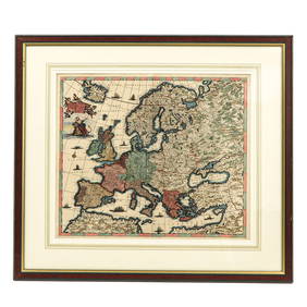
Historical map of Europe, Franz Johann Joseph vonHistorical map of Europe, Franz Johann Joseph von Reilly (1766-1820), ''The Eastern andNorthern Europe Third introductory and overview map ... to Büschings large earth description'', border colored cSee Sold Price
SoldJohnson: Four Antique Historical Maps of Europe, 1881Map: Europe Under the Romans (2nd Century). | Europe Under the Carlovingians (9th Century). | Europe Under Napoleon I. (1810-1812). | Map of The Languages of Europe. Publication Date: 1881 Authors: A.See Sold Price
Delamarche, Felix 1829 Group of 3 Maps of EuropeEurope at the time of the Charlemagne Empire and Invasions of the Barbarians. Copper Engraved Maps Published 1829, Paris for "Atlas de La Geographie..." by Felix Delamarche. Contemporary outline handSee Sold Price
Historical Maps of Europe in the German Language12 x 11 German Language Historishe karten Von Europa 1See Sold Price
SoldEurope.- Kitchin (Thomas) Imperium Caroli MagniNO RESERVE Europe.- Kitchin (Thomas) Imperium Caroli Magni Occidentis Imperatoris ad finem Saeculi Post Christum VIII.VI, historical map of Europe, engraving on J. Whatman laid paper with watermark anSee Sold Price
SoldBryce, James 1881 Lot of 4 Maps of EuropeHistorical Maps of Europe, France and Britain. Lithograph Maps Published 1881, London for ""The International Atlas and Geography..." by James Bryce. Maps by Edward Weller & John Bartholomew. UncommonSee Sold Price
Sold(3) ANTIQUE MAPS INCLUDING EUROPE , EUROPIA& 1744 , ENGLAND , IRELAND & SCOTLAND - LARGEST IS 28" x 22"See Sold Price
Sold3 Maps Including Russia, Europe, and GermanyIncludes Russia in Europe, Map of Europe, and A New Map of Germany, Thomas Cowperthwait & Co., 1850.See Sold Price
SoldLot of 2 Books incl Historical Maps of WWII Europe andLot of 2 Books incl Historical Maps of World War II Europe and Pleasure Boating Sail and PowerSee Sold Price
Raphael Jacquemin. Hand colored historical fashion plates. Medieval and early modern periods fromTremont Auctions4.5(298)See Sold PriceFeb 25, 2024
[POSTCARDS]. A Large Group of Nearly 350 Postcards on Vario...Potter & Potter Auctions4.6(550)See Sold PriceMar 07, 2024
Hand Colored Engraved Map of Europe, Jean Baptiste Bourguignon Anville 1754Global Auctions Company4.3(36)See Sold PriceMar 03, 2024
Chatelain - 3 Maps of the British Isles (England, Ireland, Scotland)Trillium Antique Prints & Rare Books4.5(33)See Sold PriceFeb 24, 2024
1822 MAP of LEEWARD ISLANDS GEOGRAPHICAL STATISTICAL HISTORICAL antique 17.5x22"Jasper524.5(9.9k)See Sold PriceFeb 27, 2024
1822 MAP of SOUTH AMERICA GEOGRAPHICAL STATISTICAL HISTORICAL antique 17.5x 22"Jasper524.5(9.9k)See Sold PriceFeb 27, 2024
1822 MAP of NORTH & SOUTH AMERICA GEOGRAPHICAL STATISTICAL HISTORICAL antiqueJasper524.5(9.9k)See Sold PriceFeb 27, 2024
1822 MAP of CHILI GEOGRAPHICAL STATISTICAL HISTORICAL antique 17.5x 22" CHILEJasper524.5(9.9k)See Sold PriceFeb 27, 2024
Clarke & Neele 1815 Map. Europe - Recent Political ChangesAlbion Auctions4.7(341)See Sold PriceMar 01, 2024
George F. Cram - Historical Map of Pittsburgh Allegheny PennsylvaniaProverde Auctions4.3(3)See Sold PriceFeb 28, 2024
ANTIQUE WEIGHTS BRONZE REPRODUCTIONS OF GRAND TOURAntique Arena Inc.4.5(883)See Sold PriceMar 09, 2024


![[POSTCARDS]. A Large Group of Nearly 350 Postcards on Vario... (1 of 2)](https://p1.liveauctioneers.com/928/318880/171361559_1_x.jpg?height=282&quality=70&version=1707501302)