Marc Chagall-Limited Edition -Paris Opera Ceiling after ChagallArt Legacy Auctions4.5(223)See Sold PriceFeb 24, 2024
Salvador Dali Pantagruel Limited Edition Lithograph Hand signed and numberedArt Legacy Auctions4.5(223)See Sold PriceFeb 24, 2024
Pablo Picasso Bouquet of Peace Collection Domaine Picasso Limited Edition on paper.Art Legacy Auctions4.5(223)See Sold PriceFeb 24, 2024
A RARE MAXFIELD PARRISH JACK AND THE BEANSTALK PRINTSoulis Auctions4.8(953)See Sold PriceFeb 24, 2024
LARGE MECHANICAL PRINT 'STARS' AFTER MAXFIELD PARRISHSoulis Auctions4.8(953)See Sold PriceFeb 24, 2024
Heinrich Aldegrever, etc. 15 old master prints. 16th-17th centuries. Aldegrever works include "ManTremont Auctions4.5(297)See Sold PriceFeb 25, 2024
Antique Map Print - Colossus Monarchic. Statua Danielis SEUTTER, Matthaus 1707Title: Antique Map Print - Colossus Monarchic. Statua Danielis SEUTTER, Matthaus 1707 Date: 1707 Material: Paper Dimensions: 28” x 22” inches / 71 cm x 56,5 cm Descritpion: One from the seSee Sold Price
SoldAfter Matthäus Seutter (German, 1678-1757) ColoAfter Matthäus Seutter (German, 1678-1757)Colossus Monarchic Statua Danielis Dan. II,See Sold Price
Seutter: Antique Map of Asia w/ Mishapen NE Asia, 1740Title/Content of Map: Asia by Seutter w mishapen NE Asia Date Printed: c1740 Cartographer: Matthaus Seutter Material/Medium: Paper Size: 23" x 19" Original hand colored copperplate engraved. PublishedSee Sold Price
SoldHand-Colored Copper Engraved Antique Maps(lot of 2) Matthäus Seutter III (German, 1678-1757), Roterodami Delineatio Ichnographica et Scenographica opera, and Heredibus Homanni (18th c.), Haga Comitum (Prospect von Graven Haag), hand-coloredSee Sold Price
Seutter: Antique Map of Western Hemisphere, 1740Title/Content of Map: Western Hemisphere with California as an Island by Seutter Date Printed: c1740 Cartographer: Matthaus Seutter Material/Medium: Paper Size: 24" x 19 1/2" Original hand colored CopSee Sold Price
SoldSeutter: Antique Map of the World, 1740Title/Content of Map: World by Seutter Date Printed: c1740 Cartographer: Matthaus Seutter Material/Medium: Paper Size: 24" x 19 1/2" Original hand colored Copperplate engraved. Published in Augsburg iSee Sold Price
SoldSeutter: Antique Map of Old Kingdom of Poland, 1740Title/Content of Map: Old Kingdom of Poland & Lithuania. Shows Baltic area & parts of Finland Date Printed: c1740 Cartographer: Matthaus Seutter Material/Medium: Paper Size: 20" x 24" Original hand coSee Sold Price
Seutter: Antique Map Balkans, Hungary to Greece, 1740Title/Content of Map: Balkan's from Hungary to Greece Date Printed: c1740 Cartographer: Matthaus Seutter Material/Medium: Paper Size: 23 1/2" x 19 3/4" Original hand colored copperplate engraved. PublSee Sold Price
Seutter: Antique Map of Spain and Portugal, 1740Title/Content of Map: Spain and Portugal Date Printed: c1740 Cartographer: Matthaus Seutter Material/Medium: Paper Size: 23 1/2" x 19 3/4" Original hand colored copperplate engraved. Published in AugsSee Sold Price
Seutter: Antique Map of Italy, 1740Title/Content of Map: Italy by Seutter Date Printed: c1740 Cartographer: Matthaus Seutter Material/Medium: Paper Size: 19 2/3" x 23 1/3" Original hand colored copperplate engraved. Published in AugsbuSee Sold Price
SoldMatthias Seutter Map of America - Novus Orbis SiveAntique Map of the Americas Hand Colored Print. Novus Orbis, Sive, America. Depicts Calif as an island.-- Dimensions: Image Size: H: 14 inches: W: 16.25 inches ---See Sold Price
Seutter: Antique Map of New England to Virginia, 1730Title/Content of Map: 1730 Seutter Map of New England to Virginia -- Recens Edita totius Novi Belgii, in America Septentrionali siti, delineatio cura et Sumtibus Date Printed: 1730, Nurnberg CartograpSee Sold Price
Seutter: Antique Map of The Balkans, 1740Title/Content of Map: The Balkans or southeastern Europe Date Printed: c1740 Cartographer: Matthuas Seutter Material/Medium: Paper Size: 19" x 23" Original hand colored copperplate engraved. PublishedSee Sold Price
SoldAntique Map Architect Blue Print Sea Captain Chest 9 drcustom made flat file cabinet for sea captain architect or blue prints,Maps, 9 drawers all on roller glides drawers work great very good condition see all pics 34 1/2" tall x 41 1/2" wide x 28" deeploSee Sold Price
SoldEight Drawer Oak Map, Art or Print File Cabinet, C 1910An antique map, art or print fining cabinet offers oak construction with eight drawers, brass pulls throughout, c1910. Measures- 45.5" H x 28" W x 22.75" D. ***IN-HOUSE SHIPPING & DELIVERY QUICK QUOTESee Sold Price
Homann / Doppelmayr: Antique Map of Solar System, 1707Doppelmayr, J. G. Homann, Iohanne Bapt.. . Nuremberg: Iohann Bapt. Homann and Johann Gabriel Dopplemayr, [1707]. This copy of the map predates the 1742 and later editions; it could be as early as 1707See Sold Price
SoldTwo Maps by Matthaus Seutter (1678-1757), "AccurataTwo Maps by Matthaus Seutter (1678-1757), "Accurata Delineatio Celeberrimae Regionis Ludocianae vel Gallice Louisiane al Canadae et Floridae adpellatione in Septemtrionali America, Mississippi, St. LoSee Sold Price
SoldAntique Map Jamaica Nova Designatio Insulae JamaicaeArtist: Seutter Title: Antique Map of Jamaica per Johannem Sellerum made and sold by John Sellers in his shops London Date: circa 1675 Medium: hand colored engraving Dimensions: 16.5 x 21 inchesSee Sold Price
SoldAntique Japanese Woodblock Print Map of Edo Tokyo Double SizeHas insect holes as shown, creases on the upper middle, otherwise good. This rare woodblock print is corner taped to the backside of the mat for protection, with a sheet size approx. 20 1/2" x 15 1/4"See Sold Price
SoldSeutter Antique Hand Coloured Map of JamaicaMatthaeus Seutter (1678-1756) Antique Hand Coloured Map of Jamaica Titled Nova Designatio Insulae Jamaicae. Map measures 20 inches H x 23 within matting, frame measures 28 x 31 inches.See Sold Price
SoldAntique Map of Mississippi and LouisianaAntique Map of Mississippi and Louisiana , 19th c., published by A. & C. Black, Edinburgh, color lithograph, sight 15 1/2 in. x 12 in., framed Provenance: Estate of Julia Evans ReedSee Sold Price
Sold2 Stacking Oak Map Print Cases. Each cabinet with2 Stacking Oak Map Print Cases. Each cabinet with 5 shallow long horizontal drawers. Metal pulls. -- Dimensions: H: 30.5 inches: W: 45.75 inches: D: 35.5 inches ---See Sold Price
SoldAntique Copper Engraving Map Asia M Suetter 19th CMap of Asia, colored copper Engraving by M Suetter, circa late 1800s. Originally purchased from Old Maps & Prints Co, Bangkok, for 4,000 baht. Framed in black and gold toned frame, wear and paint lossSee Sold Price
SoldAntique Map of LouisianaAntique Map of Louisiana , "Map of Louisiana, Representing the Several Land Districts", Surveyor General's Office, Donaldsonville, LA, Oct. 1st, 1855, Wm. J. McCulloh, Sur. Genl. La, lithograph, withSee Sold Price
Arrowsmith & Lewis - Map of North AmericaTrillium Antique Prints & Rare Books4.5(32)See Sold PriceFeb 24, 2024
Arrowsmith & Lewis - Map of the United StatesTrillium Antique Prints & Rare Books4.5(32)See Sold PriceFeb 24, 2024
Putnam - First Map of the State of Ohio by Rufus PutnamTrillium Antique Prints & Rare Books4.5(32)See Sold PriceFeb 24, 2024
Carey, pub. 1796 - A Chart of the West IndiesTrillium Antique Prints & Rare Books4.5(32)See Sold PriceFeb 24, 2024
Carey, pub. 1796 - Map of GeorgiaTrillium Antique Prints & Rare Books4.5(32)See Sold PriceFeb 24, 2024
Carey, pub. 1796 - Map of The State of South CarolinaTrillium Antique Prints & Rare Books4.5(32)See Sold PriceFeb 24, 2024
Carey, pub. 1796 - Map of KentuckyTrillium Antique Prints & Rare Books4.5(32)See Sold PriceFeb 24, 2024
Carey, pub. 1796 - Map of the Tennassee State formerly part of North Carolina (Tennessee)Trillium Antique Prints & Rare Books4.5(32)See Sold PriceFeb 24, 2024
De Jode, Rare, pub. 1593 - Map of the Czech Republic or Kingdom of Bohemia (Chorographia insignisTrillium Antique Prints & Rare Books4.5(32)See Sold PriceFeb 24, 2024
De Jode, Rare, pub. 1593 - Map of the Middle East, Eastern Asia (Primae Partis Asiae accurataTrillium Antique Prints & Rare Books4.5(32)See Sold PriceFeb 24, 2024
De Jode, Rare, pub. 1593 - Map of Africa (Africae Vera Forma, et Situs)Trillium Antique Prints & Rare Books4.5(32)See Sold PriceFeb 24, 2024
Audubon, NYSE Best Watercolor Ed - Pair: Brown Pelican & Reddish EgretTrillium Antique Prints & Rare Books4.5(32)See Sold PriceFeb 24, 2024
Audubon, Imperial Folio - American Cross Fox. 6Trillium Antique Prints & Rare Books4.5(32)See Sold PriceFeb 24, 2024
Audubon, Imperial Folio - Canada Lynx. 16Trillium Antique Prints & Rare Books4.5(32)See Sold PriceFeb 24, 2024
NORTHERN AFRICA. Morocco Tunisia Algeria. Caravan routes. RAPKIN/TALLIS 1851 mapJasper524.5(9.9k)See Sold PriceFeb 28, 2024
WEST AFRICA Explorers' routes Senegal Ashanti. Mountains of Kong. SDUK 1857 mapJasper524.5(9.9k)See Sold PriceFeb 28, 2024
WEST AFRICA Niger/Gambia rivers tribes towns. 'Pays des Negres'. MALLET 1683 mapJasper524.5(9.9k)See Sold PriceFeb 28, 2024
EARLY COLONIAL WEST AFRICA. Empires of Sokoto Gando Mas.Tribes.Fellatah 1882 mapJasper524.5(9.9k)See Sold PriceFeb 28, 2024
Pre-colonial Africa. Mountains of Kong/Moon. Caravan routes. THOMSON 1817 mapJasper524.5(9.9k)See Sold PriceFeb 28, 2024
AFRICA. Pre 'Scramble for Africa'. BARTHOLOMEW 1876 old antique map plan chartJasper524.5(9.9k)See Sold PriceFeb 28, 2024
La Barbarie de la Nigritie et de la Guinée'. West Africa. DE L’ISLE 1745 mapJasper524.5(9.9k)See Sold PriceFeb 28, 2024
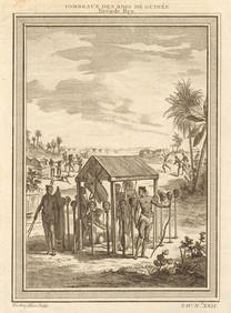
West Africa. Shrines of the Kings of Guinea, from Bry. Heads on stakes 1747Jasper524.5(9.9k)See Sold PriceFeb 28, 2024
SOUTHERN AFRICA Monomotapa (Mutapa Kingdom) Cafrerie (Kaffraria) MALLET 1683 mapJasper524.5(9.9k)See Sold PriceFeb 28, 2024