Very Rare Map UK & Ireland Abbe Gaultier 1799Wauthier, Mr. ( Gaultier, Abbe ) :MAP - A MAP OF THE BRITISH ISLES ACCORDING TO THE METHOD OF ABBE GAULTIER ,1799, ,15" x 18". ,John Harris and Son,,This very scarce map of England and Ireland is in vSee Sold Price
Rare Map British Isles Abbe Gaultier 1799Wauthier, Mr. ( Gaultier, Abbe ) MAP - A MAP OF THE BRITISH ISLES ACCORDING TO THE METHOD OF ABBE GAULTIER Published in 1799, measures 15" x 18". Published by John Harris and Son. This very scarce mapSee Sold Price
[GAULTIER] 9 maps sold together[GAULTIER] Maps by Mr. Wauthier, pupils of Abbe Gaultier (lot of 9). "A New Map of The World", 1799 ** "A Map ofEurope", 1799. ** A Plain Map of Asia”, 1797. ** "A Plain Map for The GeographicalSee Sold Price
SoldLochhead (Pub) 1811 Rare Map. IrelandCopper Engraved Map Published 1811 by William Lochhead, Berwick for "Modern Geography: And a Compendious General Gazetteer" Rare. Folds as issued. Paper Size: 10 x 8.5 inch (26 x 22cm) Very minor toniSee Sold Price
SoldBartholomew, John 1904 Lot of 4 Railway Maps UK IrelandRailways of Scotland, Ireland, England & Wales, and General Map of the British Isles with Railway & Steamship Routes. Lithograph Map Published 1904, London for "The Survey Gazetteer of the British IslSee Sold Price
SoldANTONIO ZATTA ETCHING, 1766 MAP, UK & IRELANDANTONIO ZATTA (ITALIAN, 1757-97), HAND COLORED ETCHING, 12" X 15", "1766 MAP OF THE UK & IRELAND":Image of Ireland and the UK as in 1766. Framed; under glass.See Sold Price
SoldBlackie & Weller 1882 Lot of 4 Maps. UK & IrelandIncl Ireland South Part, Scotland South Part, British Islands and The North Sea, and England & Wales. Lithograph Maps Published 1882 by Blackie & Son, London for "The Comprehensive Atlas & Geography oSee Sold Price
SoldStieler, Adolph 1905 Lot of 4 Maps. UK & IrelandLithograph Maps Published 1905 by Justus Perthes, Gotha for "Stielers Hand-Atlas" by Adolf Stieler. Centre fold as published. Paper Size: 18.5 x 15.5 inch (48 x 40cm) Good ConditionSee Sold Price
SoldBartholomew, John 1922 Lot of 8 Maps. UK & IrelandLarge Lithograph Maps Published 1922 by The Times, London for "The Times Survey Atlas of the World" Maps by John George Bartholomew of the Edinburgh Geographical Institute. Centre fold as issued. PapeSee Sold Price
Blackie & Weller 1882 Lot of 4 Maps. UK & IrelandIncl Ireland South Part, Scotland South Part, British Islands and The North Sea, and England & Wales. Lithograph Maps Published 1882 by Blackie & Son, London for "The Comprehensive Atlas & Geography oSee Sold Price
Blackie & Weller 1882 Lot of 4 Maps. UK & IrelandIncl Ireland South Part, Scotland South Part, British Islands and The North Sea, and England & Wales. Lithograph Maps Published 1882 by Blackie & Son, London for "The Comprehensive Atlas & Geography oSee Sold Price
Stieler, Adolph 1905 Lot of 4 Maps. UK & IrelandLithograph Maps Published 1905 by Justus Perthes, Gotha for "Stielers Hand-Atlas" by Adolf Stieler. Centre fold as published. Paper Size: 18.5 x 15.5 inch (48 x 40cm) Good ConditionSee Sold Price
Bartholomew, John 1922 Lot of 5 Maps. UK & IrelandIncl Ireland - North & South, Scotland - North and South, and Towns of England and Scotland. Large Lithograph Maps Published 1922 by The Times, London for "The Times Survey Atlas of the World" Maps bySee Sold Price
Bartholomew, John 1922 Lot of 5 Maps. UK & IrelandIncl Ireland - North & South, Scotland - North and South, and Towns of England and Scotland. Large Lithograph Maps Published 1922 by The Times, London for "The Times Survey Atlas of the World" Maps bySee Sold Price
SoldRARE map of IrelandTitle:RARE map of Ireland Date/Period: 1596 Materials: Copperplate engraved Dimensions: 14" x 10 1/4" A beautiful and rare map shows a portrait of Queen Elizebeth l. North oriented to the right. AlsoSee Sold Price
SoldAdvertising Poster Freightliner Network Map UK England IrelandOriginal vintage advertising poster for Freightliner network featuring a map marking the routes in red and listing terminal cities in the UK, the text below reads - Throughout the country, fully mechaSee Sold Price
SoldPhilip, George C1900 Lot of 7 Maps of UK & IrelandLithograph Maps Published C1900, London for "Philips' New Handy General Atlas of the World" by George Philip. Paper Size: 14.5 x 10.5 inch (37 x 27cm) Good ConditionSee Sold Price
SoldBartholomew, John 1922 Lot of 6 LG Maps of UK & IrelandLarge Lithograph Maps Published 1922 by The Times, London for "The Times Survey Atlas of the World" Maps by John George Bartholomew of the Edinburgh Geographical Institute. Centre fold as issued. PapeSee Sold Price
Bartholomew, John 1922 Lot of 6 LG Maps of UK & IrelandLarge Lithograph Maps Published 1922 by The Times, London for "The Times Survey Atlas of the World" Maps by John George Bartholomew of the Edinburgh Geographical Institute. Centre fold as issued. PapeSee Sold Price
Bartholomew, John 1922 Lot of 6 LG Maps of UK & IrelandLarge Lithograph Maps Published 1922 by The Times, London for "The Times Survey Atlas of the World" Maps by John George Bartholomew of the Edinburgh Geographical Institute. Centre fold as issued. PapeSee Sold Price
Bartholomew, John 1922 Lot of 6 LG Maps of UK & IrelandLarge Lithograph Maps Published 1922 by The Times, London for "The Times Survey Atlas of the World" Maps by John George Bartholomew of the Edinburgh Geographical Institute. Centre fold as issued. PapeSee Sold Price
Bartholomew, John 1922 Lot of 6 LG Maps of UK & IrelandLarge Lithograph Maps Published 1922 by The Times, London for "The Times Survey Atlas of the World" Maps by John George Bartholomew of the Edinburgh Geographical Institute. Centre fold as issued. PapeSee Sold Price
Bartholomew, John 1922 Lot of 6 LG Maps of UK & IrelandLarge Lithograph Maps Published 1922 by The Times, London for "The Times Survey Atlas of the World" Maps by John George Bartholomew of the Edinburgh Geographical Institute. Centre fold as issued. PapeSee Sold Price
Bartholomew, John 1922 Lot of 6 LG Maps of UK & IrelandLarge Lithograph Maps Published 1922 by The Times, London for "The Times Survey Atlas of the World" Maps by John George Bartholomew of the Edinburgh Geographical Institute. Centre fold as issued. PapeSee Sold Price
Chicago and Northwestern RY Travelers Companion Notebook-1880JM Hobby Supply and Railroad Artifact Auctions4.4(126)See Sold PriceFeb 24, 2024
1885 CIVIL WAR 1ed Famous Memoirs US Grant Sheridan Sherman 6v RARE LOT MapsSchilb Antiquarian Rare Books4.8(421)See Sold PriceMar 10, 2024
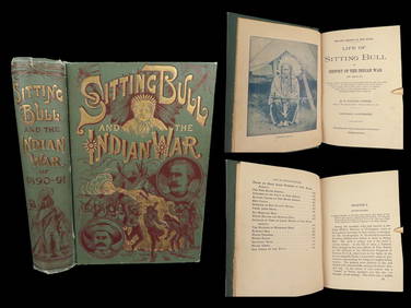
1891 Sitting Bull 1st ed Life Native American Sioux Indians DAKOTA Ghost DanceSchilb Antiquarian Rare Books4.8(421)See Sold PriceMar 10, 2024
RARE 1638 HONDIUS MAP OF BERMUDA, FRAMEDThomaston Place Auction Galleries4.4(386)See Sold PriceFeb 24, 2024
99 x EAGLE Dan Dare Comics 1958-1961 All VGC UK Scarce!Luis Porretta Fine Arts4.3(10)See Sold PriceMar 02, 2024
1818 RARE Geography Made Easy MAPS Jedidiah Morse Boston Indians Atlas AsiaSchilb Antiquarian Rare Books4.8(421)See Sold PriceMar 31, 2024
[CHICAGO]. Rare Pre-Fire Illinois Map: “Blanchard’s Map of ...Potter & Potter Auctions4.6(539)See Sold PriceMar 07, 2024
[MAP]. NICHOLLS, Sutton (1668-1729). An Epitome of Sr. Will...Potter & Potter Auctions4.6(539)See Sold PriceMar 07, 2024
Chatelain - 3 Maps of the British Isles (England, Ireland, Scotland)Trillium Antique Prints & Rare Books4.5(30)See Sold PriceFeb 24, 2024
Putnam - First Map of the State of Ohio by Rufus PutnamTrillium Antique Prints & Rare Books4.5(30)See Sold PriceFeb 24, 2024
Carey, pub. 1796 - Map of the Tennassee State formerly part of North Carolina (Tennessee)Trillium Antique Prints & Rare Books4.5(30)See Sold PriceFeb 24, 2024
De Jode, Rare, pub. 1593 - Map of the British Isles [England, Scotland, Ireland] (Angliae Scotiae etTrillium Antique Prints & Rare Books4.5(30)See Sold PriceFeb 24, 2024
De Jode, Rare, pub. 1593 - Map of the Czech Republic or Kingdom of Bohemia (Chorographia insignisTrillium Antique Prints & Rare Books4.5(30)See Sold PriceFeb 24, 2024
De Jode, Rare, pub. 1593 - Map of the Middle East, Eastern Asia (Primae Partis Asiae accurataTrillium Antique Prints & Rare Books4.5(30)See Sold PriceFeb 24, 2024
De Jode, Rare, pub. 1593 - Map of Africa (Africae Vera Forma, et Situs)Trillium Antique Prints & Rare Books4.5(30)See Sold PriceFeb 24, 2024
Donovan's The Natural History of British Shells - 5 Volumes in 3 Books with 180 EngravingsTrillium Antique Prints & Rare Books4.5(30)See Sold PriceFeb 24, 2024
Space Models Canadair Challenger E CL-610 1/50 Scale Model AircraftMiller & Miller Auctions Ltd.4.7(316)See Sold PriceMar 02, 2024


![[GAULTIER] 9 maps sold together (1 of 1)](https://p1.liveauctioneers.com/1124/187577/94368864_1_x.jpg?height=282&quality=70&version=1607095126)


![[CHICAGO]. Rare Pre-Fire Illinois Map: “Blanchard’s Map of ... (1 of 2)](https://p1.liveauctioneers.com/928/318880/171361260_1_x.jpg?height=282&quality=70&version=1707501302)
![[MAP]. NICHOLLS, Sutton (1668-1729). An Epitome of Sr. Will... (1 of 1)](https://p1.liveauctioneers.com/928/318880/171361281_1_x.jpg?height=282&quality=70&version=1707501302)


![De Jode, Rare, pub. 1593 - Map of the British Isles [England, Scotland, Ireland] (Angliae Scotiae et (1 of 2)](https://p1.liveauctioneers.com/6581/319571/171593327_1_x.jpg?height=282&quality=70&version=1707853304)


