SoldCary (John & G.) A New Map of the Principality ofCary (John & G.) A New Map of the Principality of Wales, Divided into Counties,engraved map with hand-colouring, 990 x 590mm., dissected and linen-backed, with marbled endpanels on verso, someSee Sold Price
SoldJohn Cary 'New map of the Principality of Wales'John Cary 'New map of the Principality of Wales' hand coloured engraving, published 1809, unframed, 47cm x 56 cm also one other map by Cary and five county maps by C & J Greenwood (7)See Sold Price
SoldCary (John) A New Map of HungaryCary (John) A New Map of Hungary, with divisions into Gespanchafts of Counties; the Principality of Transylvania, Croatia &c.eastern europe, former Yugoslavia, engraved map with original hand-See Sold Price
SoldJOHN CARY, HAND COLORED MAP, 1806, PART OF USAJOHN CARY, HAND COLORED MAP, 1806, "A NEW MAP OF PART OF THE UNITED STATES OF NORTH AMERICA":17 7/8" x 20 1/4", unframed. Ex. Collection Nancy and the late G. Mennen Williams.See Sold Price
SoldUS Map and Book Plate MapUS Map and Book Plate Map. A New Map of Part of the United States by John Cary; c. 1819; Some foxing and toning; 21" x 23". Small Book Plate Map of North America; London: published by G. Virtue; 13" xSee Sold Price
Cary's New Plan of London and its Vicinity, by J & G Cary. 67x85cm 1825 mapTitle: "Cary's New Plan of London and its Vicinity", by J & G Cary. 67x85cm 1825 map Description: Cary's New Plan of London and its Vicinity, 1825' by John & George Cary (1825). Antique folding city pSee Sold Price
SoldCary (John) - Cary's New Itinerary,ninth edition, calligraphic engraved title and dedication, 8 folding engraved maps including larger one of England & Wales, uncoloured, contemporary calf, rebacked in later calf, 8vo, G. & J. Cary , 1See Sold Price
SoldAtlases.- Cary (John) - New Map of England and Walesengraved title, dedication and explanation f. and and map in 78 sections numbered 1-81, mostly hand-coloured in outline, some offsetting, a few small marginal stains, occasional spotting, last page ofSee Sold Price
SoldCary (John) New Map of England and Wales, with parCary (John) New Map of England and Wales, with part of Scotland,engraved title, dedication, General Map (hand-coloured), explanation and scale sheets, and map on 76 sheets only, with originalSee Sold Price
SoldCary (John) New Map of England and WalesCary (John) New Map of England and Wales, with part of Scotland, rolling travel atlas, 81 maps sheets, including title and dedication, interspersed with Memorandums sheets, engraved maps in orSee Sold Price
SoldCary (John) New Map of England and Wales,Cary (John) New Map of England and Wales, With Part of Scotland,On which are carefully laid down All the Direct and Principal Cross Roads, the Course of the Rivers and Navigable Canals, CitiesSee Sold Price
SoldCary (John) New Map of France, Divided into DepartCary (John) New Map of France, Divided into Departments, as decreed by the National Assembly, January 1st 1790,William Houstoun's copy, engraved map with original hand-colouring in outline, 61See Sold Price
SoldCary (John) New Map of England and WalesCary (John) New Map of England and Wales, with part of Scotland,On which are carefully laid down-All the Direct and Principal Crofs Roads, the Course of the Rivers and Navigable Canals, CitiesSee Sold Price
SoldCary (John) New Map of England and WalesCary (John) New Map of England and Wales, with part of Scotland,On which are carefully laid down-All the Direct and Principal Crofs Roads, the Course of the Rivers and Navigable Canals, CitiesSee Sold Price
FFRAN Cary (John) New Map of France, Divided intoFFRAN Cary (John) New Map of France, Divided into Departments, as decreed by the National Assembly, January 1st 1790,William Houstoun's copy, engraved map with original hand-colouring in outliSee Sold Price
-.Cary (John) - New Map of England and Wales with Partengraved title, dedication and explanation f. and and map in 78 sections numbered 1-81, mostly hand-coloured in outline, some offsetting, a few small marginal stains, occasional spotting, last page ofSee Sold Price
SoldCanada.- Cary (John) A New Map of Upper & Lower Canada;NO RESERVE Canada.- Cary (John) A New Map of Upper & Lower Canada; A New Map of Nova Scotia, Newfoundland &c., two maps of Canada from Cary's 'New Universal Atlas', engravings with hand-colouring, eacSee Sold Price
SoldIreland.- Cary (John) Cary's New Map of Ireland,Ireland.- Cary (John) Cary's New Map of Ireland, exhibiting the whole of the Turnpike Roads with the Rivers and Canals, engraving with original hand-colouring in outline, 770 x 620 mm (30 x 24 1/4 in)See Sold Price
SoldEngland & Wales.- Cary (John) Cary's New Map of EnglandEngland & Wales.- Cary (John) Cary's New Map of England & Wales with Part of Scotland..., unsual format with map presented as loose plates in slipcase, including title, general map, and sheets 1-80, lSee Sold Price
SoldCARY, JOHN. A New Map of the United States of America,CARY, JOHN. A New Map of the United States of America, From the Latest Authorities. Double-page engraved map of the eastern United States. 20¾x22¾ inches sheet size, wide margins; original hSee Sold Price
SoldCARY, JOHN. A New Map of Part of the United StCARY, JOHN. A New Map of Part of the United States of North America, exhibiting the Western Territory, Kentucky, Pennsylvania, Maryland, Virginia &c. Double-page engraved map, 520x600 mm, wide marginsSee Sold Price
Sold(CANADA.) Cary, John. A New Map of Upper & Low(CANADA.) Cary, John. A New Map of Upper & Lower Canada. Double-page engraved map, 520x605 mm, wide margins; lakes and topographical elements hand-colored; scattered minor browning. London, 1807 AllSee Sold Price
SoldCARY, JOHN. A New Map of Part of the United States ofCARY, JOHN. A New Map of Part of the United States of North America, Exhibiting the Western Territory, Kentucky, Pennsylvania, Maryland, Virginia &c. Double-page engraved map of the Great Lakes and WeSee Sold Price
SoldCary (John) A New Map of the East India IslesCary (John) A New Map of the East India Isles,engraved map with original hand-colouring, 500 x 550mm., central vertical fold, slight spotting, mostly marginal with slight damp-staining at sheeSee Sold Price
[CIVIL WAR]. A group of 10 illustrated covers featuring political cartoons depicting AfricanFreeman's | Hindman4.4(1.6k)See Sold PriceFeb 27, 2024
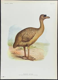
Rothschild, Extinct - Rodrigues Solitaire (Pezophaps Solitaria). 23Trillium Antique Prints & Rare Books4.5(32)See Sold PriceFeb 24, 2024
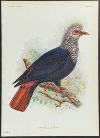
Rothschild, Extinct - Mauritius Blue Pigeon (Alectroenas Nitidissima). 22Trillium Antique Prints & Rare Books4.5(32)See Sold PriceFeb 24, 2024
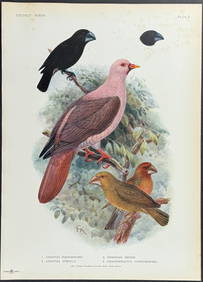
Rothschild, Extinct - Ground Finch, Pink Pigeon, & Bonin Grosbeak (Geospiza Magnirostris, GeospizaTrillium Antique Prints & Rare Books4.5(32)See Sold PriceFeb 24, 2024
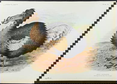
Rothschild, Extinct - Dodo Bird (Didus Cucculatus) with 3 Additional Outline PlatesTrillium Antique Prints & Rare Books4.5(32)See Sold PriceFeb 24, 2024
Map: A 19thC engraved map titled Gloucestershire from the Best Authorities, after John Cary. Approx.Claydon Auctioneers Ltd4.3(125)See Sold PriceFeb 26, 2024
Map: A 19thC engraved and hand coloured map of Buckingham titled A New Map of BuckinghamshireClaydon Auctioneers Ltd4.3(125)See Sold PriceFeb 26, 2024
Map: A 19thC engraved map of West Riding, titled A Map of the North Part of the West Riding ofClaydon Auctioneers Ltd4.3(125)See Sold PriceFeb 26, 2024
1855 NOTES ON CENTRAL AMERICA by E. G. Squier antique w/ MAPSJasper524.5(9.9k)See Sold PriceFeb 27, 2024
1711 GREEK BIBLE ILLUSTRATED w/ MAPS VELLUM BOUND antique NEW TESTAMENTJasper524.5(9.9k)See Sold PriceFeb 27, 2024
Fielding (Henry) The Works, with An Essay on His Life and Genius by Arthur Murphy, 10 vol., newForum Auctions4.3(53)See Sold PriceFeb 29, 2024
Kent & Sussex.- Moss (W.G.) The History and Antiquities of the Town and Port of Hastings, 1824; andForum Auctions4.3(53)See Sold PriceFeb 29, 2024


![[CIVIL WAR]. A group of 10 illustrated covers featuring political cartoons depicting African (1 of 2)](https://p1.liveauctioneers.com/197/319238/171468106_1_x.jpg?height=282&quality=70&version=1707520367)