Davies (Benjamin Rees) Davie's New Map of the BritDavies (Benjamin Rees) Davie's New Map of the British Metropolis,showing from Hornsey down to Mitcham Common, and Plaistow across to East Acton, lithographed map with hand-colouring, and severSee Sold Price
SoldDavies (Benjamin Rees) Davie's New Map of the BritDavies (Benjamin Rees) Davie's New Map of the British Metropolis,showing from Hornsey down to Mitcham Common, and Plaistow across to East Acton, lithographed map with hand-colouring, 980 x 990See Sold Price
SoldLondon.- Davies (Benjamin Rees) Davies' New map ofNO RESERVE London.- Davies (Benjamin Rees) Davies' New map of London and its Environs, Showing the New Railway Stations and Other Improvements, from Finchley to Anerley, and from Barking Level to HanwSee Sold Price
SoldDavies (Benjamin Rees) - Davies' New Map of LondonShowing the New Railway Stations and Other Improvements, from Finchley to Anerley, and from Barking Level to Hanwell, lithographed map with full hand-colouring, 735 x 1115mm., dissected and linen-bacSee Sold Price
SoldDavies' New Map of the British Metropolis[Davies (Benjamin Rees)] Davies' New Map of the British Metropolis, The Boundaries of the Boroughs, County Court Districts, Railways, and Modern Improvements, from Stamford Hill to Peckham, anSee Sold Price
SoldDavies (Benjamin Rees) - Davies's New Map of thefrom Hornsey to South Norwood, and from Chiswick to Victoria Dock, a circle marking the 4-mile radius from Charing Cross, engraved map with original hand-colouring, 985 x 940mm., dissected and linen-bSee Sold Price
SoldWaterlow & Sons Davies's Map Of The Environs OfDavies (Benjamin Rees) Davies's Map Of The Environs Of London, engraved map with hand-colouring in outline, 1070 x 750mm., dissected and linen-backed, faint browning, a few creases to upper coSee Sold Price
SoldDavies (Benjamin Rees) Davies's Map of the EnvironDavies (Benjamin Rees) Davies's Map of the Environs of London,showing all railway developments, parks and reservoirs, from Potters Bar to Chipstead, and from Windsor to Thurrock, engraved mapSee Sold Price
Davies (Benjamin Rees) Davies's Map of the EnvironDavies (Benjamin Rees) Davies's Map of the Environs of London,showing all railway developments, parks and reservoirs, from Potters Bar to Chipstead, and from Windsor to Thurrock, engraved mapSee Sold Price
SoldDavies (B. R.) Map of the Environs of LondonDavies (Benjamin Rees) Davies's Map of the Environs of London,showing all railway developments, parks and reservoirs, from Potters Bar to Chipstead, and from Windsor to Thurrock, engraved mapSee Sold Price
SoldLondon.- Davies (Benjamin Rees) Davies's Map of theLondon.- Davies (Benjamin Rees) Davies's Map of the Environs of London, showing from Potters Bar to Dartford, and Leatherhead to Slough, engraved map with contemporary hand-colouring, 750 x 1070 mm (2See Sold Price
SoldLondon.- Davies (Benjamin Rees) Davies's Map of theNO RESERVE London.- Davies (Benjamin Rees) Davies's Map of the Environs of London, large folding map centred on Westminster, showing from Waltham Abbey to Dartford, and Epsom to Windsor, engraving, 76See Sold Price
London.- Davies (Benjamin Rees) [Environs of London],London.- Davies (Benjamin Rees) [Environs of London], showing from Tottenham across to Abbey Wood, down to Lower Streatham and across to Ealing in the West, with decorative border, engraved map with sSee Sold Price
Davies (Benjamin Rees) London and its EnvironsDavies (Benjamin Rees) London and its Environs,showing from Tottenham down to Bromley, and Barking across to Hanwell, lithographed map, with original hand-colouring, 570 x 730mm., dissected anSee Sold Price
SoldDavies (Benjamin Rees) LondonDavies (Benjamin Rees) London,from Archway to The Oval, and from Kensington Gardens to Blackwall, for the Society for the Diffusion of Useful Knowledge, engraved map with full original hand-coSee Sold Price
London.- Davies (Benjamin Rees)London.- Davies (Benjamin Rees) [Environs of London], showing from Tottenham to Abbey Wood, to Lower Streatham and across to Ealing, steel engraved map, decorative border, outlined in colour, dissecteSee Sold Price
Davies (Benjamin Rees) London. Drawn and EngravedDavies (Benjamin Rees) London. Drawn and Engraved expressly for the Post Office Directory,showing from Highgate down to Brixton Hill, and Plaistow across to East Acton, lithographed map with hSee Sold Price
Davies (Benjamin Rees) Liverpool and its EnvironsDavies (Benjamin Rees) Liverpool and its Environs including the Cheshire Coast,with reference and key to Churches, Chapels, Public Buildings and other institutions, engraved map with hand-coloSee Sold Price
SoldLondon.- Davies (Benjamin Rees) London and itsLondon.- Davies (Benjamin Rees) London and its Environs, Containing the Boundaries of the Metropolitan Boroughs, the different Railroads & Stations, The New Cemetaries, Roads, Docks, Canals, and all tSee Sold Price
SoldLondon.- Davies (Benjamin Rees) London, [1876].London.- Davies (Benjamin Rees) London, engraving with hand-colouring, platemark 480 x 600 mm. (18 7/8 x 23 5/8 in), sheet 450 x 760 mm. (17 3/4 x 30 in), two vertical folds as issues, some minor nickSee Sold Price
Sold1813 Geography Atlas MAPS Benjamin Davies World Turkey1813 Geography Atlas MAPS Benjamin Davies World Turkey ASIA USA Ireland Davies’ “A new system of modern geography” was written as a middle ground between the verbose grammars of Pinkerton, GuthrSee Sold Price
Sold1813 Geography Atlas MAPS Benjamin Davies World Turkey ASIA USA Ireland1813 Geography Atlas MAPS Benjamin Davies World Turkey ASIA USA Ireland Davies “A new system of modern geography” was written as a middle ground between the verbose grammars of Pinkerton,See Sold Price
Davies (Benjamin Rees) - Davies's Map of the Environsfrom Potter's Bar to Leatherhead, and from Windsor to Thurrock, engraved map with full original hand-colouring, 760 x 1100mm., dissected and linen-backed, slight browning, folding into contemporary blSee Sold Price
Davies (Benjamin Rees) - Davies's Map of the Environsfrom Potter's Bar to Leatherhead, and from Windsor to Thurrock, engraved map with full original hand-colouring, 760 x 1100mm., dissected and linen-backed, slight browning, folding into contemporary blSee Sold Price
1892 Adams and Bowles New Road Map of the State of New YorkJM Hobby Supply and Railroad Artifact Auctions4.4(127)See Sold PriceFeb 24, 2024
Central Railroad of New Jersey Map of Sandy Hook Route-ca. 1903JM Hobby Supply and Railroad Artifact Auctions4.4(127)See Sold PriceFeb 24, 2024
Crams Railroad Map of New York-1881JM Hobby Supply and Railroad Artifact Auctions4.4(127)See Sold PriceFeb 24, 2024
Crams Township and Railroad Map of New York-1890JM Hobby Supply and Railroad Artifact Auctions4.4(127)See Sold PriceFeb 24, 2024
Vintage County Map Of NY State Plate EngravingThe Benefit Shop Foundation Inc.4.3(2.9k)See Sold PriceFeb 28, 2024
Portfolio of 15 County Maps by Robert Morden (English 1650-1703)Nadeau's Auction Gallery4.7(409)See Sold PriceFeb 24, 2024
1855 Map of New York & Erie Railroad and 1917 Trespassing On Railway Property Is A MisdemeanorRail & Road Auctions4.6(165)See Sold PriceMar 07, 2024
Keith Haring - Ink on New York Map, Best Buddies, Inscribed, Signed, and DatedSapphire Auction Gallery4(67)See Sold PriceMar 02, 2024
[ARCTIC]. BOWEN, Emanuel. A New & Accurate Map of the North...Potter & Potter Auctions4.6(545)See Sold PriceMar 07, 2024
Keith Haring Artwork Signed on a Shell Oil New York Road Map 18 in. x 24 in.Donny Malone Auctions4.4(1.8k)See Sold PriceMar 04, 2024
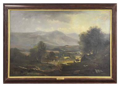
O/C BENJAMIN CHAMPNEY "NEW HAMPSHIRE LANDSCAPE" 19THC. (31 3/4" X 48")Carlsen Gallery, Inc.4.6(164)See Sold PriceMar 03, 2024
New and Correct Map of North America With the West India Islands,Jasper524.5(9.9k)See Sold PriceFeb 27, 2024
Two Hand-Colored 19th Century Maps of New Orleans and Louisiana, Larger- H.- 12 1/2 in., W.- 15 1/2Crescent City Auction Gallery4.3(231)See Sold PriceMar 08, 2024
SIGNED. ROBERTSON DAVIES: THE MANTICORE. 1972. 1ST ED.Toronto Book Auctions4.3(13)See Sold PriceMar 07, 2024
Herman Moll A New Map of Ye North Parts of AmericaWillow Auction House4.5(289)See Sold PriceMar 14, 2024


![London.- Davies (Benjamin Rees) [Environs of London], (1 of 1)](https://p1.liveauctioneers.com/5458/137660/69840726_1_x.jpg?height=282&quality=70&version=1551869179)


![London.- Davies (Benjamin Rees) London, [1876]. (1 of 1)](https://p1.liveauctioneers.com/5458/147572/74579051_1_x.jpg?height=282&quality=70&version=1565275641)


![[ARCTIC]. BOWEN, Emanuel. A New & Accurate Map of the North... (1 of 1)](https://p1.liveauctioneers.com/928/318880/171360917_1_x.jpg?height=282&quality=70&version=1707501302)