Sold1892 George Walker map of Bristol County, MAOriginal 1891 map by George Walker showing parts of Bristol county massachusetts and part of Rhode Island. Towns shown include Wesport, Dartmouth, Fairhaven, Mattapoisett, and Fall River. Also showingSee Sold Price
Walker's map of Bristol County, MaRestrike of an 1891 Walker's map showing the towns of Bristol County, Massachusetts. Towns include Westport, Dartmouth, Fairhaven etc.. and lower Plymouth County with Rochester and Mattapoisett. AlsoSee Sold Price
Walker's map of Bristol County, MaRestrike of an 1891 Walker's map showing the towns of Bristol County, Massachusetts. Towns include Westport, Dartmouth, Fairhaven etc.. and lower Plymouth County with Rochester and Mattapoisett. AlsoSee Sold Price
Map of Cape Cod - Barnstable Village, MAMaps of Cape Cod - Barnstable Village, MA. Bacon Farm Grist Mill, Huckins Creek S.B Phinney, Coggins Pond, Atlas of Barnstable County 1880: Plate 36. Publisher: George H. Walker, 1880. Size of OriginaSee Sold Price
Sold1891 Map of Duxbury & PlymouthOriginal 1891 map of Kingston, Plymouth and Bourne, Massachusetts. George Walker map detailing Plymouth County and Cape Cod Bay. Matted and framed. 26 1/2" high x 36 1/2" wide.See Sold Price
SoldBristol County Map.recreation of a 1891 Walker's map showing Mattapoisett, Fairhaven, New Bedford, Westport and Little Compton. Also showing Fall River and Swansea. Details include roadways and rivers. Overall dimensionSee Sold Price
Sold1871 ATLAS OF BRISTOL COUNTY, MA. PUBLISHED BY FW BEERS & CO., MAIDEN LANE, NY. ALL MAPS PRESENT. DETACHED FROM BOARD, BLANK FRONTIS PAGE SHOWS TEARS. PAGE EDGES SHOW SLIGHT CHIPPING, TITLE PAGE SHOWS LIGHT DAMAGE, AND SOME PAGES SHOW MINOR INSECTSee Sold Price
SoldBOUND ATLAS OF "BRISTOL COUNTY", MA, 1871,F. W. BEERS & CO.; TITLE PAGE IS BADLY TOWN; MINOR CHIPPING TO MAPS; ALL PAGES AND MAPS ARE PRESENT.See Sold Price
SoldWall map of Marin County 1892Heading: Author: Dodge, George M. Title: Official Map of Marin County, California 1892 Compiled from Records and Surveys Place Published: San Francisco Publisher:Schmidt Label & Lith. Co. DateSee Sold Price
SoldWall map of Marin County 1892Heading: Author: Dodge, George M. Title: Official Map of Marin County, California 1892 Compiled from Records and Surveys Place Published: San Francisco Publisher:Schmidt Label & Lith. Co. DateSee Sold Price
SoldWall map of Marin County 1892Heading: (California - Marin County) Author: Dodge, George M. Title: Official Map of Marin County, California 1892 Compiled from Records and Surveys Place Published: San Francisco Publisher:Schmidt LaSee Sold Price
SoldWall map of Marin County 1892Heading: Author: Dodge, George M. Title: Official Map of Marin County, California 1892 Compiled from Records and Surveys Place Published: San Francisco Publisher:Schmidt Label & Lith. Co. DateSee Sold Price
Sold19TH C. BOUND ATLAS; MAPS OF TOWNS Atlas of Plymouth19TH C. BOUND ATLAS; MAPS OF TOWNS Atlas of Plymouth County, Massachusetts, 1879, published by George H. Walker & Co., Boston, Mass., 92 pgs; along with four pages of lists of Manufacturers and MerchaSee Sold Price
Sold1891 Map of Nantucket, George H. Walker19th Century lithographic map of Nantucket depicts detailed image of Nantucket Island with shoals. "MASSACHUSETTS PLATE No 10", signed "GEO H. WALKER & Co BOSTON, MA". Light age tone. Measures 19.5 HSee Sold Price
Sold1790 Nashville TN Land Grant & Survey MapLand grant dated 1790 and survey map dated 1792, concerning land in Davidson County, Tennessee, granted by governor Richard Speight and the State of North Carolina to George Walker, assignee of PrivatSee Sold Price
IllinoisPublication Date: 1895 Title: Illinois Cartographer: CRAM, GEORGE F. Publisher: H. B. WALKER Double page map of the state with railroads. Inset of part of Cook County. Late for hand coloring. From WalSee Sold Price
SoldUNFRAMED MAP OF "THE CITY OF FALL RIVER", MA,FROM BRISTOL COUNTY ATLAS 1871; 15 5/8" X 23 5/8".See Sold Price
SoldFramed Walker’s map of South Shore, MALater copy of the 1904 Walker’s map of the South Shore with parts of Norfolk and Plymouth counties. With topographical detail for the towns for Braintree, Weymouth, Hingham, Scituate, Marshfield, DuSee Sold Price
SoldGEORGE WALKER ATLAS BOOK OF PLYMOUTH COUNTY:Ca. 1879. Atlas of Plymouth County, Massachusetts, 1879 First Edition published by George H. Walker & Co. Boston, Mass. Consists of 92 pages along with four pages of lists of Manufacturers and MerchanSee Sold Price
SoldLOT OF 22 MAPS OF THE UNITED STATESLOT OF 22 MAPS OF THE UNITED STATES. 1. 1871-PLYMOUTH COUNTY. 2. 1871-HAMPSHIRE COUNTY, HAMPDON COUNTY. 3. 1871-BRISTOL COUNTY. 4. 1871-BRISTOL COUNTY. 5. 1871-BERKSHIRE COUNTY. 6. 1892-CITY OF LOWELLSee Sold Price
SoldAtlas of Plymouth CountyGeorge H. Walker and Co., Boston, atlas of Plymouth County, dated 1879, with center fold panorama of Nantasket beach, 18 1/2" h x 15" w. Provenance: MA estate.See Sold Price
Maryland And DelawarePublication Date: 1895 Title: Maryland And Delaware Cartographer: CRAM, GEORGE F. Publisher: H. B. WALKER Double page regional map of Delmarva with railroads. Inset of Baltimore County. From Walker'sSee Sold Price
SoldTWO 19TH C BOUND ATLASES TO INCLUDE NEW BEDFORD1881, PUBLISHED BY GEORGE H. WALKER, BOSTON, MA, 79 PAGES WITH ILLUSTRATIONS AND MAPS. 18" X 14 1/4". SPINE IS BROKEN, CORNERS BADLY SCUFFED, BLANK FRONTISE AND TITLE PAGE ARE TORN. THE REST OF THE ATSee Sold Price
Atlas of Cuyahoga County & City of Cleveland Ohio''Atlas of Cuyahoga County and the City of Cleveland Ohio'', George F. Cram & Co., Publishers, Chicago, 1892, 23 1/4 x 27 3/4'', all maps, Cuyahoga County Portraits & Biographies, and Business ReferenSee Sold Price
Crams Map of North Dakota-Complete Railroad System and County Map-1907JM Hobby Supply and Railroad Artifact Auctions4.4(126)See Sold PriceFeb 24, 2024
Rand McNally Township County and Railroad Map of Illinois-1879JM Hobby Supply and Railroad Artifact Auctions4.4(126)See Sold PriceFeb 24, 2024
Rand McNally Township County and Railroad Map of Indiana-1880JM Hobby Supply and Railroad Artifact Auctions4.4(126)See Sold PriceFeb 24, 2024
DUNLEVIE c1856 Map Counties Of Gaspe & Bonaventure Quebec Canada SCARCE! #2Luis Porretta Fine Arts4.3(10)See Sold PriceMar 02, 2024
DUNLEVIE c1856 Map Counties Of Gaspe & Bonaventure Quebec Canada SCARCE! #1Luis Porretta Fine Arts4.3(10)See Sold PriceMar 02, 2024
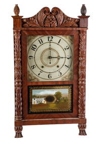
CARVED FEDERAL PERIOD SPLIT COLUMN SHELF CLOCKJohn McInnis Auctioneers,LLC4.6(504)See Sold PriceFeb 24, 2024
Vintage County Map Of NY State Plate EngravingThe Benefit Shop Foundation Inc.4.3(2.9k)See Sold PriceFeb 28, 2024
Portfolio of 15 County Maps by Robert Morden (English 1650-1703)Nadeau's Auction Gallery4.7(405)See Sold PriceFeb 24, 2024
1892 AMERICAN PAINTING BY GEORGE HENRY HALL SIGNEDAntique Arena Inc.4.5(866)See Sold PriceFeb 24, 2024
Cooke, George 1801 Antique Map. United States of AmericaAlbion Auctions4.6(341)See Sold PriceMar 01, 2024
George F. Cram - Historical Map of Pittsburgh Allegheny PennsylvaniaProverde Auctions4.3(3)See Sold PriceFeb 28, 2024