SoldMitchell map of West with Gold Region 1849Title: Oregon, Upper California & New Mexico Author: Mitchell, Samuel Augustus Description: Engraved map, hand-colored. 41x32 cm. (16¼x12½") including decorative border.Western America at the beginnSee Sold Price
SoldMitchell map of West with Gold Region 1849Title: Oregon, Upper California & New Mexico Author: Mitchell, Samuel Augustus Description: Engraved map, hand-colored. 41x32 cm. (16¼x12½") including decorative border.Western America at the beginnSee Sold Price
SoldMap with early reference to gold region 1849Title: No. 15 Map of Oregon and Upper California Engraved to Illustrate Mitchell's School and Family Geography. Author: Mitchell, S. Augustus Description: Lithographed map, hand-colored. 26.5x20.8 cm.See Sold Price
SoldMitchell's Oregon & California with Gold Region 1849Heading: Author: Mitchell, Samuel Augustu Title: Oregon, Upper California & New Mexico Place Published: Philadelphia Publisher:S. Augustus Mitchell Date Published: 1849 Description: </See Sold Price
SoldJarves map of California Gold Region 1849Heading: Author: Jarves, James Jackson Title: A Correct Map of the Bay of San Francisco and the Gold Region from actual Survey June 20th 1849 for J.J. Jarves. Embracing all the new Towns, Ranchos, RoSee Sold Price
SoldLawson map of California Gold Regions 1849Heading: Author: Lawson, John T. Title: Lawson's Map from Actual Survey of the Gold, Silver & Quicksilver Regions of Upper California Exhibiting the Mines, Diggings, Roads, Paths, Houses, Mills, StorSee Sold Price
SoldItalian map of U.S. West with gold region 1851Heading: Author: Marzolla, B[enedetto] Title: Nuova California (Stati Uniti dell'America Settentrionale) Place Published: [Naples] Publisher: Date Published: 1851 Description: LSee Sold Price
Colton map of U.S. with Gold Region 1849Title: Map of the United States, the British Provinces, Mexico &c. Showing the Routes of the U.S. Mail Steam Packets to California and a Plan of the Gold Regions Author: Colton, J.H. Description: FoldSee Sold Price
Italian map of U.S. West with gold region 1851Heading: Author: Marzolla, B[enedetto] Title: Nuova California (Stati Uniti dell'America Settentrionale) Place Published: [Naples] Publisher: Date Published: 1851 Description: <See Sold Price
Italian map of U.S. West with gold region 1851Heading: Author: Marzolla, B[enedetto] Title: Nuova California (Stati Uniti dell'America Settentrionale) Place Published: [Naples] Publisher: Date Published: 1851 Description: <See Sold Price
SoldMap of Bonneville's Adventures with Gold Region 1849Heading: Author: Colton, J.H. Title: Map to Illustrate Capt. Bonneville's Adventures among the Rocky Mountains Place Published: New York Publisher:Geo. P. Putnam Date Published: 1849 DSee Sold Price
SoldMap of U.S. with routes to Gold Region 1849Title: Map of the United States, the British Provinces, Mexico &c. Showing the Routes of the U.S. Mail Steam Packets to California and a Plan of the Gold Regions Author: Colton, J.H. Description: LithSee Sold Price
Robinson's Gold Regions with map 1849Heading: Author: Robinson, Fayette Title: California and its Gold Regions; With a Geographical and Topographical View of the Country, its Mineral and Agricultural Resources. Prepared from Official anSee Sold Price
SoldWall map of U.S. 1849 with Gold RegionTitle: Pictorial Map of the United States 1849 Author: Ensign & Thayer Description: Lithographed wall map, hand-colored, surrounded by pictures of historical events. 47x73 cm. (18½x28¾") plus the enSee Sold Price
SoldWilkes map of California 1849 with gold regionTitle: Map of Upper California by the U.S. Ex. Ex. and Best Authorities 1849 Author: Wilkes, Charles Description: Lithographed map. 21.7x29 cm. (8¾x11½").Embraces the territory between the Rocky MouSee Sold Price
SoldWilkes map of California 1849 with gold regionTitle: Map of Upper California by the U.S. Ex. Ex. and Best Authorities 1849 Author: Wilkes, Charles Description: Lithographed map. 21.7x29 cm. (8¾x11½").Embraces the territory between the Rocky MouSee Sold Price
SoldROBINSON, F. California and its Gold Regions. 1849512. ROBINSON, Fayette. California and its Gold Regions; With a Geographical and Topographical View of the Country, Its Mineral and Agricultural Resources... With A Map of the U. States and CaliforniaSee Sold Price
Sold1846 Mitchell hand-colored map of North CarolinaFeatures an inset of the Gold Region. Clean and highly collectible map of the Tar Heel state. When matted and framed this map will become a lovely, cherished specimen of wall art that is actually a piSee Sold Price
SoldGERSTÄCKER. Kaliforniens Gold... Leipzig, 1849160. GERSTÄCKER, Fr[iedrich Wilhelm Christian]. [Cover title with map showing Gold Region] Preis 5 Sgr. Kaliforniens Gold- U. Quecksilber-District. Nach: the California-Herald von Fr. GerstäSee Sold Price
Mitchell: Antique Map of North Carolina, 18461846 Mitchell hand-colored map of North Carolina. Features an inset of the Gold Region. Clean and highly collectible map of the Tar Heel state. When matted and framed this map will become a lovely, chSee Sold Price
SoldMITCHELL, Samuel. Pocket map with text106. [MAP]. MITCHELL, Samuel Augustus. Pocket map with text: Text: MITCHELL, Samuel Augustus. Description of Oregon and California, Embracing an Account of the Gold Regions; To Which Is Added, An AppeSee Sold Price
SoldDerby map of California Gold RegionTitle: Sketch of General Riley's Route through the Mining Districts July and Aug. 1849 Author: Derby, George Horatio Description: Lithographed map. 53.7x49.5 cm. (21x19½").Central California includinSee Sold Price
Derby map of California Gold RegionTitle: Sketch of General Riley's Route through the Mining Districts July and Aug. 1849 Author: Derby, George Horatio Description: Lithographed map. 53.7x49.5 cm. (21x19½").Central California includinSee Sold Price
SoldDerby map of California Gold RegionTitle: Sketch of General Riley's Route through the Mining Districts July and Aug. 1849 Author: Derby, George Horatio Description: Lithographed map. 53.7x49.5 cm. (21x19½").Central California includinSee Sold Price
1849 Mitchell School ATLAS 24 MAPS America Holy Land France Africa Egypt AsiaSchilb Antiquarian Rare Books4.8(431)See Sold PriceMar 31, 2024
1849 THE NEW-ENGLAND MERCANTILE UNIONNorth American Artifact Auctions4.7(201)See Sold PriceApr 20, 2024
[ARCTIC]. BOWEN, Emanuel. A New & Accurate Map of the North...Potter & Potter Auctions4.6(550)See Sold PriceMar 07, 2024
WEST AFRICA. British Cameroons & Togoland mandates. Gold Coast Nigeria 1947 mapJasper524.5(9.9k)See Sold PriceFeb 28, 2024
NORTH & WEST AFRICA. Gold Coast (Ghana) Slave Coast. Tribal names 1890 mapJasper524.5(9.9k)See Sold PriceFeb 28, 2024
WEST AFRICA. French. Gold Coast Ghana. inset Gambia; Sierra Leone 1920 mapJasper524.5(9.9k)See Sold PriceFeb 28, 2024
WESTERN AFRICA.Kong Mountains.Caravan routes.Slave Coast.TALLIS/RAPKIN 1849 mapJasper524.5(9.9k)See Sold PriceFeb 28, 2024
WEST AFRICA I Explorers' routes Senegal Ashanti Ivory Gold Coast. SDUK 1851 mapJasper524.5(9.9k)See Sold PriceFeb 28, 2024
Colonial & French West Africa. Gold Coast Dahomey Upper Volta. TIMES 1922 mapJasper524.5(9.9k)See Sold PriceFeb 28, 2024
North & West Africa. Dahomey. Gold Coast. Military Territory. THE TIMES 1922 mapJasper524.5(9.9k)See Sold PriceFeb 28, 2024
WESTERN AFRICA.Kong Mountains.Caravan routes.Slave Coast.TALLIS/RAPKIN 1851 mapJasper524.5(9.9k)See Sold PriceFeb 28, 2024
FRENCH WEST AFRICA Nigeria Gold Coast Rio de Oro Portuguese Guinea 1912 mapJasper524.5(9.9k)See Sold PriceFeb 28, 2024
French West Africa. Gold Coast. Sahara desert sand dunes. TIMES 1956 mapJasper524.5(9.9k)See Sold PriceFeb 28, 2024
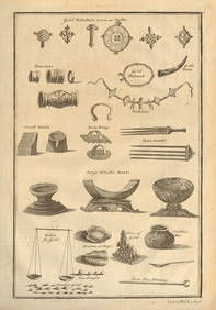
West Africa gold trinkets worn as spells and utensils. jewels ornaments 1745Jasper524.5(9.9k)See Sold PriceFeb 28, 2024


![[ARCTIC]. BOWEN, Emanuel. A New & Accurate Map of the North... (1 of 1)](https://p1.liveauctioneers.com/928/318880/171360917_1_x.jpg?height=282&quality=70&version=1707501302)