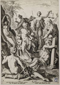
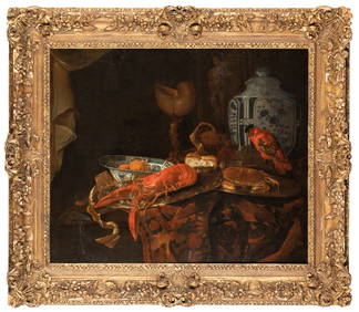
SoldWeltkarte (van der Aa): Nova delineatio totius orbWeltkarte (van der Aa) - Nova delineatio totius orbis terrarum ... Abbildung der beiden Hemisphären, dazwischen Allegorien des Tages und der Nacht, in den Ecken Allegorien der vier Elemente. KupferstSee Sold Price
Weltkarte (van der Aa): Nova delineatio totius orbWeltkarte (van der Aa) - Nova delineatio totius orbis terrarum ... Abbildung der beiden Hemisphären, dazwischen Allegorien des Tages und der Nacht, in den Ecken Allegorien der vier Elemente. KupferstSee Sold Price
Pieter van der Aa, 'Nova Delineatio Totius Orbis',Pieter van der Aa (1659-1733) – Dutch engraver, book printer and publisher 'Nova Delineatio Totius Orbis Terrarum Per Petrum Van Der Aa' – Appealingly colored copper world map with both hemisphereSee Sold Price
Sold[World Map]. van der Aa, Pieter [1659-1733]. Nova[World Map]. van der Aa, Pieter [1659-1733]. Nova Delineatio Totius Orbis Terrarum [Niewe Werelt Caart]. Copperplate engraved dual-hemisphere map, insular California [c1710-1730]. 10 1/8 x 13 5/8 in wSee Sold Price
SoldAa (Pieter van der) Twin hemisphere worldAa (Pieter van der) Nova Delineatio Totius Orbis Terrarum, double-hemisphere world map, showing California as an island, vestiges of New Zealand coast and most of Australia, with allegorical fSee Sold Price
Sold[World Map]. van der Aa, Pieter [1659-1733]. Nova[World Map]. van der Aa, Pieter [1659-1733]. Nova Delneatio Totius Orbis Terrarum [Niewe Werelt Caart]. Copperplate engraved dual-hemisphere map, insular California [c1710-1730]. Image 10 1/8 x 13 5/8See Sold Price
SoldNach Jan Aertse van den Ende. Weltkarte (1635 - 1649)Nova totius terrarum orbis geographica ac hydrographica tabula. Rechts oben bezeichnet wohl Guiljelmus BLAEU (1600 - 1699). Größe: 298 mm x 395 mm der Druck. Farbiger Kupferstich, LithoraphiSee Sold Price
SoldVan der Keere World MapVan der Keere, Pieter (1571- c.1646). Nova Totius Terrarum Orbis Geographica Ac Hydrographica Tabula. Engraved map with original hand color in full. Amsterdam: Janssonius, 1608 [but circa 1630] 19" xSee Sold Price
van der Aa: Antique Map, View of Ancient Syracuse, 1725Title: Delineatio Syracusarum Antiquarium Quadriurbium, Rare 1725 bird's-eye-view of ancient Syracuse, Sicily Map maker: Pieter van der Aa Place and Year: Amsterdam, c. 1725 Dimensions: 35 x 46 cm (13See Sold Price
SoldPieter Van der Aa, colored engraving, circa 1728, fromPieter Van der Aa, colored engraving, circa 1728, from Galerie Agreable du monde, Novum Amstelodamum, Novel Amsterdam, Manhattan's er Amerique, Nouvelle Hollande, and Animalia peregrina nova HollandiaSee Sold Price
van der Aa: Antique View of Ancient Syracuse, SicilyTitle: Delineatio Syracusarum Antiquarium Quadriurbium Map maker: Pieter van der Aa Place and Year: Amsterdam, c. 1725 Dimensions: 35 x 46 cm (13.8 x 18.1 in) Technique: Copperplate engraving ColoringSee Sold Price
SoldAa (Pieter van der) Orbis TerrarumAa (Pieter van der) Orbis Terrarum Nova et Accuratissima Tabula, double-hemisphere world map, showing California as an island, a formative globe as a ball of clay above, between the hemisphereSee Sold Price
SoldAa (Pieter Van der) Londini Angliae Regni MetropolAa (Pieter Van der) Londini Angliae Regni Metropolis Delineatio Accuratissima,plan of London, with a 10 point key bearing the names of Southwark landmarks, upper left, a 148 point key of locatSee Sold Price
SoldWeltkarte (Danckerts): Nova totius terrarum orbisWeltkarte (Danckerts) - Nova Totius Terrarum Orbis Tabula. Abbildung der beiden Hemisphären, dazwischen zwei kleine Polkarten, in den Ecken allegorische Darstellungen der vier Elemente. Kupferstich mSee Sold Price
Sold3 x Historische Karten. Afrika, Europa, Welt.- Nicolas Visscher. Africae - Afrika. Ausgeführt wohl 1652. Kupferstich alt coloriert. 435 mm x 561 der Druck. - Claes Janszoon Visscher II (1587 - 1652), Weltkarte, Nova Totius Terrarum Orbis GeSee Sold Price
Soldvan der Aa: T Noorder deel Vaa Amerika, 1707Map: T Noorder deel Vaa Amerika Maker: Peiter van der Aa Date: 1707 Description: Map of North America with California shown as an island. Many place names on California's west coast Size: 8 x 11.8 incSee Sold Price
Soldvan der Aa: Antique Map of Southeast US, 1713Map: La Floride Suivant les Nouvelles Observations de Messrs. de l'Academie Royale des Sciences (eastern seaboard to New Mexico) Cartographer: van der Aa Place & Date: Leiden / 1713 Size: 14 7/8" x 10See Sold Price
SoldPieter van Der Aa, 'Kanton' City View 1670Pieter van Der Aa, 'Kanton in platte grondt'. Leiden, 1670. Plan of Guangzhou, China. On sheet measuring 12x14.25''. Trimmed inside right and lleft side impressions.See Sold Price
SoldPieter van der Aa: Map of Ireland, 1713Map: L'Irlande Suivant Les Nouvelles Observations De Messrs De l'Academie Royale Des Sciences, Etc. Augmentees De Nouveau. (1713 Map of Ireland) Cartographer: Pieter Van Der Aa Date: 1713 Size: 8.75 xSee Sold Price
1715 Original Engraved World Map by Pieter van der AaAn original copper engraved hand-colored double-hemispherical map of the world by Pieter Van der Aa (1659-1733). This map was published in Amsterdam in 1715. It features mythological figures representSee Sold Price
SoldPIETER VAN DER AA 18TH C ENGRAVING: MAP OF VENICEPieter Van Der Aa 18th century engraved map of Venice, Italy. Printed circa 1720, Leiden. Titled lower left " Celeberrima Urbs Venetiae", and below "Lugd. Bat. Excudit Petrus Vander Aa.". Matted and uSee Sold Price
SoldPIETER VAN DER AA (DUTCH, 1659-1733) MAP OF VIRGINIAPIETER VAN DER AA (DUTCH, 1659-1733) MAP OF VIRGINIA, on laid paper, titled "d'Engelze Volkplanting / in / VIRGINIE / door / IOHAN SMITH / Bezogt en verder uytgeset" to cartouche in lower right quadraSee Sold Price
Sold(2) PIERRE VAN DER AA 17TH C. ENGRAVINGSMarked on bottom "La Porte de la conference" and "Luxembourg." One of Luxembourg Palace and gardens, other of gateway to Paris. Both with center folds as published and modern hand-coloring. In FrenchSee Sold Price
Soldvan der Aa: Antique Map of Southeast East Indies, 1729Map: La Partie des Indes Orientales vers le Zud-Est Cartographer: Pieter vander AA Place & Date: Leiden / 1729 Size: 13 1/2" x 11 1/2" Condition: outline color; light overall age toning A classic mapSee Sold Price
Set of 10 Books Including, Zim Gabrielson, Sibylle Von Olfers, Van Der Post, Germaine Geer & MoreCain Modern Auctions4.4(44)See Sold PriceFeb 28, 2024
Nova Totius Full Color Geographical World MapThe Benefit Shop Foundation Inc.4.3(2.9k)See Sold PriceFeb 28, 2024
11 Old Master prints. 16th-18th centuries. To include: Jacob Matham "Prudence", Pieter van derTremont Auctions4.6(293)See Sold PriceFeb 25, 2024
Georges Van der Straeten (1856-1928) - "Diana the Huntress" Sculpture in bronze with two patinas.GOLDFIELD AUCTION4.3(32)See Sold PriceMar 02, 2024
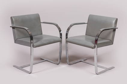
Ludwig MIES VAN DER ROHE (1886-1969) : Paire de fauteuils modèle Brno en métal chromé. H. 80 - L.Valoir Pousse-Cornet4.3(4)See Sold PriceFeb 24, 2024
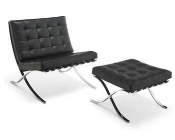
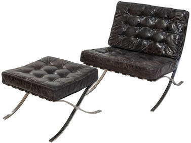
Ludwig Mies Van Der Rohe (1886-1969), A Barcelona chair and ottoman for Knoll Studio, 21st centuryJohn Moran Auctioneers, Inc.4.7(453)See Sold PriceFeb 27, 2024
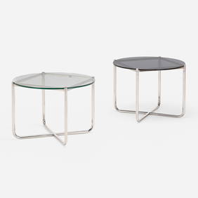
Mies van der Rohe for Knoll Barcelona Coffee TableAuctions at Showplace4.5(726)See Sold PriceMar 17, 2024
De Jode, Rare, pub. 1593 - Map of Italy (Italiae Totius Orbis olim Domatricis Nova ExactissTrillium Antique Prints & Rare Books4.5(30)See Sold PriceFeb 24, 2024
After Ludwig Mies Van Der Rohe (German/American, 1886-1969), Barcelona Chair and Matching Ottoman,Crescent City Auction Gallery4.3(229)See Sold PriceMar 09, 2024
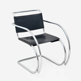
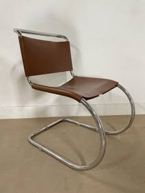
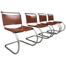
van der Rohe, Ludwig Mies: Freischwinger MR 10Peter Karbstein Kunst und Auktionshaus4.2(9)See Sold PriceMar 16, 2024
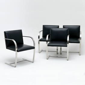
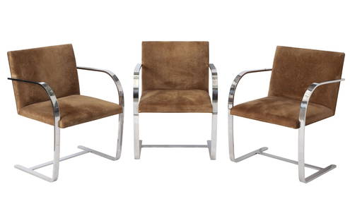
Set of Six Mies van der Rohe Upholstered and Stainless Steel "Brno" Armchairs For KnollDOYLE Auctioneers & Appraisers4.6(166)See Sold PriceMar 06, 2024


![[World Map]. van der Aa, Pieter [1659-1733]. Nova (1 of 1)](https://p1.liveauctioneers.com/179/1435/617550_1_x.jpg?height=282&quality=70)

![[World Map]. van der Aa, Pieter [1659-1733]. Nova (1 of 1)](https://p1.liveauctioneers.com/179/2417/1045283_1_x.jpg?height=282&quality=70)