SoldAn Accurate Map of the Counties of Gloucester andRobert Sayer, An Accurate Map of the Counties of Gloucester and Monmouth, engraving, 1709, folio, 27.5 x 21.5 27.5 x 21.5See Sold Price
Bowen (Emanuel) An Accurate Map of the Counties ofBowen (Emanuel) An Accurate Map of the Counties of Leicester and Rutland,Divided into their respective hundreds, decorative title and dedication cartouche, lower left and right, with detailedSee Sold Price
SoldEmanuel Bowen/An Accurate Map of the Counties ofEmanuel Bowen/An Accurate Map of the Counties of Gloucestershire and Monmouth Divided into Respective Hundreds/printed by John Bowles, Carington Bowles and Robert Sayer 1760/hand coloured engraved mapSee Sold Price
SoldAn Accurate Map of the County of Surrey. c.1750.[England] Bowen, Emanuel. “An Accurate Map of the County of Surrey; Divided into its Hundreds.” London, c.1750. Engraved map. 27 7/8” x 20 3/4”. Framed: 31” x 24”.See Sold Price
SoldEMMANUEL BOWEN AN ACCURATE MAP OF THE COUNTY OF SEmmanuel Bowen An Accurate Map of the County of Suffolk, Divided into its Hundreds hand coloured engraved map 51.5 x 69cm (plate)See Sold Price
SoldEmmanuel Bowen: 'An Accurate Map of the County ofEmmanuel Bowen: 'An Accurate Map of the County of Surrey' with dedication to Lord Onslow, 21" x 28", framedSee Sold Price
SoldGibson (John) - New and Accurate Maps of the Countiesengraved throughout, title and 52 maps only (of 53, lacking plate 19), contemporary calf, rubbed, 12mo, for T.Carnan, [c.1780].See Sold Price
SoldEmanuel Bowen Accurate Map of the County of Kent,Emanuel Bowen engraving, Accurate Map of the County of Kent, 20.5 x 27.5 ins.See Sold Price
SoldBowen (Emanuel) An Accurate Map of The County ofBowen (Emanuel) An Accurate Map of The County of LLancaster divided into its hundreds with ornamental cartouche, engraved map, hand colouring, 700 x 530 mm., central horizontal fold, trimmedSee Sold Price
SoldBowen (Emanuel) An Accurate Map of the County ofBowen (Emanuel) An Accurate Map of the County of Essex, Divided into its Hundreds, with architectural title cartouche with pastoral scene, side panels of architectural and topographical notes,See Sold Price
SoldEMMANUEL BOWEN AN ACCURATE MAP OF THE COUNTY OF HEmmanuel Bowen An Accurate Map of the County of Huntingdon, Divided into its Hundreds hand coloured engraved map 50 x 39cm (image)See Sold Price
1777 Bowen Map of County Kent, England -- An Accurate Map of the County of Kent, Divided into itsTitle: 1777 Bowen Map of County Kent, England -- An Accurate Map of the County of Kent, Divided into its Lathes… Cartographer: E Bowen Year / Place: 1777, London Map Dimension (in.): 16 X 19.6 iSee Sold Price
"An Accurate Map of the County of Kent divided into itsEmanuel Bowen (fl. 1714-died 1767) - Engraving - "An Accurate Map of the County of Kent divided into its Lathes" - Showing views of Canterbury and Rochester Cathedral | Measures 16" H x 19.5" W, printSee Sold Price
SoldBowen (Emanuel) - An Accurate Map of the County of Kentinset map of the Isle of Thanet, upper right, large vignette title of hop-picking and maritime figures and objects, lower left, engraved map with oroginal hand-colouring in outline, 530 x 720mm., dissSee Sold Price
SoldBowen (E) An Accurate Map Of The County of NorfoBowen (Emanuel) An Accurate Map Of The County of Norfolk, with large decorative cartouche, engraved map, with original outline hand-colouring, 530 x 720mm., central vertical fold, with some spSee Sold Price
SoldBowen (Emanuel) - An Accurate Map of the County of Kentlarge vignette title of maritime and agricultural subjects, lower left, inset coastal chart from North Foreland to South Foreland, upper right, engraved map with original hand-colouring, 530 x 690mm.,See Sold Price
1777 Bowen Map of County Kent, England -- An Accurate Map of the County of Kent, Divided into itsTitle: 1777 Bowen Map of County Kent, England -- An Accurate Map of the County of Kent, Divided into its Lathes… Cartographer: E Bowen Year / Place: 1777, London Map Dimension (in.): 16 X 19.6 iSee Sold Price
SoldSussex.- Bowen (Emanuel) An Accurate Map of the CountySussex.- Bowen (Emanuel) An Accurate Map of the County of Sussex. Divided into its Rapes, Deaneries, and Hundreds, decorated with vignette views and inset plans of Lewes and Chichester, with two decorSee Sold Price
Sussex.- Bowen (Emanuel) An Accurate Map of the CountySussex.- Bowen (Emanuel) An Accurate Map of the County of Sussex. Divided into its Rapes, Deaneries, and Hundreds, decorated with vignette views and inset plans of Lewes and Chichester, with two decorSee Sold Price
Antique Bowles & Sayer Map of Leicester & RutlandA hand-colored antique map by Emanuel Bowen, circa 1756, :An Accurate Map of the Counties of Leicester & Rutland, Divided into their Respective Hundreds"; printed by Bowles & Sayer. Size : 32" x 26" fSee Sold Price
1760 Kitchin Map of Durham England -- An Accurate MapTitle/Content of Map: 1760 Kitchin Map of Durham England -- An Accurate Map of the County Palatine of Durham Date Printed: 1760 c London Cartographer: T. Kitchin Size: 21 x 27 in. A very visually impaSee Sold Price
T. Kitchin: Map of the County Palatine of Durham, 1760Map: An Accurate Map of the County Palatine of Durham Maker: T. Kitchin Date: ca. 1760 Origin: London Size: 21 x 17 inches A very visually impactful map of County Durhan in the 18th century with a weaSee Sold Price
Kitchin: Antique Map of Durham England, 1760Title: 1760 Kitchin Map of Durham England -- An Accurate Map of the County Palatine of Durham Cartographer: T. Kitchin Year / Place: 1760 c London Map Dimensions: 21 x 27 Condition: Excellent. Clear,See Sold Price
SoldEmmanuel Bowen (1714-1767) - Coloured engraving - “An AEmmanuel Bowen (1714-1767) - Coloured engraving - “An Accurate Map of the County of Kent divided into its Lathes and Sub Divided into Hundreds”, 20ins x 27ins, published by John Tinney, John BowleSee Sold Price
Crams Map of North Dakota-Complete Railroad System and County Map-1907JM Hobby Supply and Railroad Artifact Auctions4.4(127)See Sold PriceFeb 24, 2024
Map UNITED COUNTIES LEEDS & GRENVILLE by Walling 1861 Rare Canada Map 5ft x 5ftLuis Porretta Fine Arts4.3(10)See Sold PriceMar 02, 2024
DUNLEVIE c1856 Map Counties Of Gaspe & Bonaventure Quebec Canada SCARCE! #2Luis Porretta Fine Arts4.3(10)See Sold PriceMar 02, 2024
DUNLEVIE c1856 Map Counties Of Gaspe & Bonaventure Quebec Canada SCARCE! #1Luis Porretta Fine Arts4.3(10)See Sold PriceMar 02, 2024
Vintage County Map Of NY State Plate EngravingThe Benefit Shop Foundation Inc.4.3(2.9k)See Sold PriceFeb 28, 2024
Portfolio of 15 County Maps by Robert Morden (English 1650-1703)Nadeau's Auction Gallery4.7(409)See Sold PriceFeb 24, 2024
[ARCTIC]. BOWEN, Emanuel. A New & Accurate Map of the North...Potter & Potter Auctions4.6(545)See Sold PriceMar 07, 2024
Map: An 18thC engraved map of Bedfordshire titled An Accurate Map of the County of Bedford DividedClaydon Auctioneers Ltd4.3(125)See Sold PriceFeb 26, 2024
1764 MAP OF COUNTRIES THIRTY MILES ROUND LONDON antique 12.5 by 15"Jasper524.5(9.9k)See Sold PriceFeb 27, 2024
1738 RUSSIA SIBERIA & GREAT TARTARY Description illustrated ANTIQUE in ENGLISHJasper524.5(9.9k)See Sold PriceFeb 27, 2024
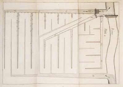
Wright (Thomas) The Art of Floating Land, as is practised in the County of Gloucester, J.Rider, 1799Forum Auctions4.3(53)See Sold PriceFeb 29, 2024
1750 Bowen Map of Bermuda and St. Kitts -- A New & Accurate Map of Bermudas or Sommer's Islands...Jasper524.5(9.9k)See Sold PriceFeb 27, 2024


![[ARCTIC]. BOWEN, Emanuel. A New & Accurate Map of the North... (1 of 1)](https://p1.liveauctioneers.com/928/318880/171360917_1_x.jpg?height=282&quality=70&version=1707501302)