SoldFRAMED & GLAZED MAP OF FLORIDA, FROMRAND McNALLY & COMPANY, LATE 19TH C., 19 1/4" X 15"See Sold Price
SoldVINTAGE ATLAS MAP, WARWICK, BELLVALE & FLORIDA, NY.VINTAGE ATLAS MAP, WARWICK, BELLVALE & FLORIDA, NY. FRAMED & GLAZED-21 X 31"See Sold Price
SoldFRAMED & GLAZED MAP OF MARYLAND,BY THOMAS COWPERTHWAIT, CIRCA 1850, SHOWS ONE INCH TEAR, 12" X 15"See Sold Price
Rand, McNally FLORIDA Map, circa 1892Rand, McNally FLORIDA, circa 1892. This is a large format map of Florida in the early 1890’s, from the Rand, McNally Indexed Atlas of the World. It is framed with a date matching genuine Morgan SilvSee Sold Price
SoldFRAMED & GLAZED MAP OF IRELAND, 7 1/2 X 6 1/2CIRCA 1680, PUBLISHED IN PARIS BY PIERRE DUVALSee Sold Price
SoldFRAMED & GLAZED MAP OF COUNTIES OFCHESTER, DAUPHIN, BERKS, LEBANON & YORK AND LANCASTER, CIRCA 1872, 17" X 26"See Sold Price
SoldA Framed 19th Century Map of Florida, Height of printA Framed 19th Century Map of Florida, circa 1855, lithography printing by Bowne & Hasbrouck, New York, titled "U.S. Coast Survey...Sketch F... with a General Reconaissance of the Coast of Florida 1848See Sold Price
Circa 1900, framed, colored map of Florida, 8 1/2Circa 1900, framed, colored map of Florida, 8 1/2"x9 1/2"See Sold Price
SoldJOHNSON'S MAP OF FLORIDA CIRCA 1863 PUBLISHED BYJOHNSON'S MAP OF FLORIDA CIRCA 1863 PUBLISHED BY JOHNSON AND WARD, HAND COLORED, VERY GOOD CONDITION, FRAMED SIZE 22"W X 18"H, SKU896.10See Sold Price
SoldJOHNSON'S MAP OF FLORIDA CIRCA 1863 PUBLISHED BYJOHNSON'S MAP OF FLORIDA CIRCA 1863 PUBLISHED BY JOHNSON AND WARD, HAND COLORED, VERY GOOD CONDITION, FRAMED SIZE 22"W X 18"H, SKU896.10See Sold Price
SoldBLAEU (JOHANNES), LINCOLNIA COMITATUS ANGLIS LINCOLN-SHIREBLAEU (JOHANNES), LINCOLNIA COMITATUS ANGLIS LINCOLN-SHIRE Amsterdam, circa 1645, engraved map with contemporary outline colouring, decorative cartouche and mileage scale, framed and glazed. VisibleSee Sold Price
SoldEarly map of FloridaEarly map of Florida Amsterdam, circa 1671PAGUS HISPANORUM IN FLORIDA (St. Augustine)engraving, framed; unsigned.image size: H10 1/2" W14"Provenance: Purchased from Shaver Books, Savannah, Georgia.See Sold Price
SoldJ. Lodge (British, 18th Century)J. Lodge (British, 18th Century), "A Map of Part of West Florida", hand colored engraved map, 1772, sight 7-5/8" x 13-5/8". Glazed, matted and framed.See Sold Price
SoldA 17th century country map-engraving after Willem & JanA 17th century country map-engraving after Willem & Jan Blaeu (circa 1640), Hantonia (Hampshire), 42 x 51 cm, mounted, framed and glazedSee Sold Price
Sold[Relief Map of the SouthernAppalachian Region] by Julius Bien (1826-1909), circa 1902 (possibly later), 18-3/4 x 22-3/4 in. (sight); framed in a handsome distressed wood frame, 25 x 29 in. evidence of folding, minute amount ofSee Sold Price
Sold"A MAP OF THE BRITISH PLANTATIONS, CANADA, FLORIDA"A MAP OF THE BRITISH PLANTATIONS, CANADA, FLORIDA". Copper plate engraving, published in London in 1747; framed and glazed - 9 1/2 in. x 10 in.See Sold Price
SoldMercator/Hondius Candia: c. 1630. Map of CreteMercator/Hondius Candia: "Candia cum Infulis aliquot circa Graeciam", 1630. Map of Crete and other islands. Size is 20" x 14". Nice old coloring and choice. Old Florida Collection. Matted and framed.See Sold Price
SoldMercator/Hondius Map of Candia (Crete)Mercator/Hondius Candia: "Candia cum Infulis aliquot circa Graeciam", 1630. Map of Crete and other islands. Size is 20" x 14". Nice old coloring and choice. Old Florida Collection. Matted and framed.See Sold Price
Sold[Bookplates]. Collection of Fifteen Bookplates w[Bookplates]. Collection of Fifteen Bookplates with Map or Globe Themes [N.p., n.d., thouSee Sold Price
SoldNicolas Bellin (French, fl. circa 1740-1802)Nicolas Bellin (French, fl. circa 1740-1802) large oblong hand-colored engraved world map, 1748, 21-1/2" x 30", litho-signed in the plate. Presented in a narrow fruitwood framed and glazed.See Sold Price
SoldHOMANN HEIRS MAP, "DOMINIA ANGLORUM IN AMERICAHOMANN HEIRS MAP, "DOMINIA ANGLORUM IN AMERICA SEPTENTRIONALI SPECIALIBUS" SHOWING NEW ENGLAND, CHESAPEAKE, GEORGIA, CAROLINAS, FLORIDA AND NOVA SCOTIA, C.1740. SIGHT 20 X 23"; FRAMED AND GLAZEDSee Sold Price
A.J. Bailey English Estate c.1902-Present Sterling Silver Salad Serving Set 2pcMynt Auctions4.6(680)See Sold PriceFeb 23, 2024
Hand Colored Map of the city of Amsterdam 1720Global Auctions Company4.3(36)See Sold PriceMar 03, 2024
Doyle Lane (1923-2002), Studio tile wall assemblageJohn Moran Auctioneers, Inc.4.7(453)See Sold PriceFeb 27, 2024
17th Century Hand Colored Engraved Map of GermanyGlobal Auctions Company4.3(36)See Sold PriceMar 03, 2024
18th Century Hess Germany Hand colored Engraved MapGlobal Auctions Company4.3(36)See Sold PriceMar 03, 2024
RUSSIAN ITALIAN OIL PAINTING BY FEODOR BRONNIKOFFAntique Arena Inc.4.5(852)See Sold PriceFeb 24, 2024
A MAP OF THE STRAND OF THE NORTH SIDE OF CHANNEL OF RIVER ANNA LIFFE, 1811 Engraving, 680 x 480mmAdam's Auctioneers4.3(5)See Sold PriceFeb 27, 2024
Map of St. Kitts and Nevis Depot de la Marine, Paris, 1758Global Auctions Company4.3(36)See Sold PriceMar 03, 2024
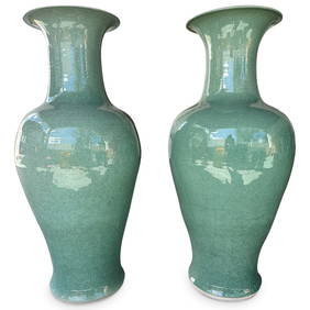
Pair Monumental Chinese Porcelain Monochrome Crackle Glazed Baluster VasesAkiba Galleries4.7(1.7k)See Sold PriceFeb 29, 2024
Irian by Wallace Sterling Silver Button Hook 6 1/2" Circa 1902 HH WSMynt Auctions4.6(680)See Sold PriceFeb 26, 2024
English Estate c.1902-Present Sterling Silver Coronation Spoon light GW 6 1/2"Mynt Auctions4.6(680)See Sold PriceFeb 29, 2024
ANTIQUE TIFFANY & CO 925 STERLING SILVER HANDMADE THREE-HANDLED LOVING CUP VASEMynt Auctions4.6(680)See Sold PriceMar 01, 2024


![[Bookplates]. Collection of Fifteen Bookplates w (1 of 3)](https://p1.liveauctioneers.com/906/80657/41936209_1_x.jpg?height=282&quality=70&version=1445283342)