Sold1855 map of United StatesHeading: Author: Cummings & Hillliard Title: The United States Place Published: Boston Publisher: Date Published: c.1815 Description: Copper-engraved map, hand-colored. 20.See Sold Price
SoldTwo 19th Century Maps of East Central US166. Two 19th Century Maps of East Central US: 1855 Map of Central United States with Counties Highlighted, 11" x 17 1/2". Black & White Map of Maryland, Virginia, West Virginia and North Carolina. 9"See Sold Price
Sold1855 PICTURE MAP OF THE UNITED STATES, PUBLISHED BY1855 PICTURE MAP OF THE UNITED STATES, PUBLISHED BY ENSIGN BRIDGEMAN AND FANNINGSee Sold Price
1855 Colton Map of the United States -- The UnitedTitle/Content of Map: 1855 Colton Map of the United States -- The United States of America Date: 1855, New York Cartographer: J Colton Size: 14.6 X 25 in. This is an outstanding large US map. It doesSee Sold Price
SoldAN 1855 NEW MAP OF THE UNITED STATES BY LIPPENCOTTHand colored, detailed map; includes part of Canada and Cuba, inset of the Pacific NW. Professionally matted in archival materials, 24.75 x 29.75 inch sight size.See Sold Price
1855 Colton Map of the United States -- The UnitedTitle/Content of Map: 1855 Colton Map of the United States -- The United States of America Date: 1855, New York Cartographer: J Colton Size: 14.6 X 25 in. This is an outstanding large US map. It doesSee Sold Price
1855 Colton Map of the United States -- The UnitedTitle/Content of Map: 1855 Colton Map of the United States -- The United States of America Date: 1855, New YorkCartographer: J Colton Size: 14.6 X 25 in. This is an outstanding large US map. It does fSee Sold Price
1855 Colton Map of the United States -- The UnitedTitle/Content of Map: 1855 Colton Map of the United States -- The United States of America Date: 1855, New York Cartographer: J Colton Size: 14.6 X 25 in. This is an outstanding large US map. It doesSee Sold Price
1855 Colton Map of the United States -- The UnitedTitle: 1855 Colton Map of the United States -- The United States of America Date: 1855, New York Cartographer: J Colton Size: 14.6 X 25 in. Additional Information: This is an outstanding large US map.See Sold Price
1855 Colton Map of the United States -- The UnitedTitle/Content of Map: 1855 Colton Map of the United States -- The United States of America Date: 1855, New York Cartographer: J Colton Size: 14.6 X 25 in. This is an outstanding large US map. It doesSee Sold Price
SoldOrnamental Map of United States 1855Heading: Author: Ensign, Bridgman & Fanning Title: Ornamental Map of the United States & Mexico / Map of the United States and Mexico Place Published: New York Publisher:Ensign, Bridgman & Fanning, PSee Sold Price
SoldGROUP OF 5 ASSORTED MAPS1892 MAP OF BAHAMA ISLANDS BY TUNISAN,1850 MAO OF PERSIA AND ARABIA BY THOS. COPERTHWAIT,1802 UNITED STATES MAP BY ALEXANDRE BLONDEAU,1855 WESTERN HEMISPHERE MAP BY J.H. COLOTN AND AN 1836 MAP OF SOUTSee Sold Price
SoldJ. H. Colton: Map of United States of America, 1855The United States of America. J. H. Colton, 1855. 15.75 x 26. From the 1856 second edition of Colton’s Atlas of the World. Clean with very minor edge toning. Couple of tiny margin spots. One extremeSee Sold Price
Sold1855 Map of Georgetown and the City of Washington by J.H. ColtonColton's Georgetown and the city of Washington: the capital of the United States of America. Issued in 1855 by J. H. Colton (1800-1893). Hand colored. Frame size: 20 1/2" H x 24 3/4" W x 1 1/8" D. SigSee Sold Price
SoldSmith: Antique Railroad Map of the United States, 1855Map: Map of the United States of America, Showing the Rail Roads. Large, Colorful Railroad Map of U.S. 1855 Publication Date: 1855 Authors: HARPER & BROTHERS, SMITH, J. CALVIN / D. MCLELLAN Publisher:See Sold Price
Sold(2) 1846 & 1855 Maps Washington DC, DeSilverGroup of (2) maps of Washington, DC from the mid-19th century: a) Joseph B. Varnum Map of the City of Washington Established as the Permanent Seat of the Government of the United States of America, enSee Sold Price
SoldUncommon map of the United States from 1855Heading: (North America) Author: Heck, G. Title: Vereinigte Staaten von Nordamerika Nebst Mexico Und Central Amerika Place Published: Leipzig Publisher:G. Heck Date Published: 1855 DescSee Sold Price
Sold1855 Smith Map of the MidWest -- Guide through Ohio,Title/Content of Map: 1855 Smith Map of the MidWest -- Guide through Ohio, Michigan, Indiana, Illinois, Missouri, Wisconsin & Iowa Showing the Township Lines of the United States Surveys Date Printed:See Sold Price
Antique 1855 Smith Map of the MidWestTitle/Content of Map: 1855 Smith Map of the MidWest -- Guide through Ohio, Michigan, Indiana, Illinois, Missouri, Wisconsin & Iowa Showing the Township Lines of the United States Surveys Date Printed:See Sold Price
1855 Colton Map of Washington DC -- Georgetown and theReserve Reduced! Title/Content of Map: 1855 Colton Map of Washington DC -- Georgetown and the City of Washington the Capital of the United States of America Date: 1855, New York Cartographer: J ColtonSee Sold Price
1855 Wall Map of US and MexicoMap of the United States with its Territories: Also Mexico and the West Indies … 1855 [Wall Map]. Lithographed wall map with hand color. New York: Ensign, Bridgman & Fanning, 1855. 36 1/2 x 35 1/2 iSee Sold Price
Sold1855 Colton Map of Washington DC -- Georgetown and theTitle/Content of Map: 1855 Colton Map of Washington DC -- Georgetown and the City of Washington the Capital of the United States of America Date: 1855, New York Cartographer: J Colton Size: 11.8 X 14.See Sold Price
SoldCOLTON, Joseph Hutchins (1800-1893). Nebraska andCOLTON, Joseph Hutchins (1800-1893). Nebraska and Kansas. New York, 1855. Engraved map with hand coloring, 737 x 544 mm sheet. Inset maps of the United States and the territory acquired in the GadsdenSee Sold Price
American Express/New York Central Railroad Map of the United States-1934JM Hobby Supply and Railroad Artifact Auctions4.4(126)See Sold PriceFeb 24, 2024
Union Pacific RR Map of the United States-1926JM Hobby Supply and Railroad Artifact Auctions4.4(126)See Sold PriceFeb 24, 2024
United States Map with American Flag 3-D Wall Mount PaintingWeatherham Estate Treasures3.9(157)See Sold PriceFeb 29, 2024
1905 20th Century Atlas of Boone County IllinoisMatthew Bullock Auctioneers4.7(1.8k)See Sold PriceFeb 24, 2024
Arrowsmith & Lewis - Map of the United StatesTrillium Antique Prints & Rare Books4.5(30)See Sold PriceFeb 24, 2024
Wilson - Wood Thrush, Red-breasted Thrush or Robin, & Nuthatches. 2Trillium Antique Prints & Rare Books4.5(30)See Sold PriceFeb 24, 2024
Wilson - Grosbeak, Warbler, Siskin, & Flycatcher. 17Trillium Antique Prints & Rare Books4.5(30)See Sold PriceFeb 24, 2024
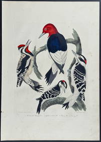
Wilson - Woodpeckers - Red-headed, Yellow-bellied, Hairy, & Downy. 9Trillium Antique Prints & Rare Books4.5(30)See Sold PriceFeb 24, 2024
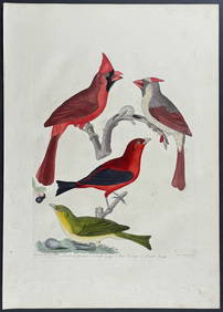
Wilson - Cardinal Grosbeak & Red Tanager. 11Trillium Antique Prints & Rare Books4.5(30)See Sold PriceFeb 24, 2024
Wilson - Mottled Owl, Lark, Creeper, & Warbler. 19Trillium Antique Prints & Rare Books4.5(30)See Sold PriceFeb 24, 2024
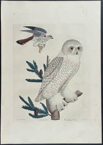
Wilson - Snow Owl (Snowy Owl) & Sparrow Hawk. 32Trillium Antique Prints & Rare Books4.5(30)See Sold PriceFeb 24, 2024
Wilson - Ivory-billed Woodpecker, Red-headed & Pileated Woodpeckers. 29Trillium Antique Prints & Rare Books4.5(30)See Sold PriceFeb 24, 2024
Wilson - Carolina Parrot & Flycatchers. 26Trillium Antique Prints & Rare Books4.5(30)See Sold PriceFeb 24, 2024
Cooke, George 1801 Antique Map. United States of AmericaAlbion Auctions4.6(336)See Sold PriceMar 01, 2024
Blackie (Pub) 1882 Folio Map. United States of North AmericaAlbion Auctions4.6(336)See Sold PriceMar 01, 2024
Map of United States of North America, 1785Antiques Online Auctions4.6(407)See Sold PriceMar 14, 2024
Vintage 1920s Rand McNally Auto Trails MapThe Benefit Shop Foundation Inc.4.3(2.9k)See Sold PriceMar 20, 2024