Vintage Ca. 1940's International Panel Delivery Truck Converted into Stationary Food Truck, WasSwisher Bros. Auction LLC4.4(241)See Sold PriceFeb 25, 2024
Martin Custom Acoustic Guitar 000 Body Style Rosewood with Hard CaseHess Fine Auctions4.5(197)See Sold PriceMar 02, 2024
1968 Gibson LG-0 Acoustic Dreadnought Parlor GuitarHess Fine Auctions4.5(197)See Sold PriceMar 02, 2024
Replica Robinson 1862 Sharps CarbineSchmidt's Antiques Inc. Since 19114.8(431)See Sold PriceMar 02, 2024
PAIR (18th c) OF FLINTLOCK DUELING PISTOLSJohn McInnis Auctioneers,LLC4.6(502)See Sold PriceFeb 24, 2024
PAIR T KETLAND of LONDON .60 CAL FLINTLOCK PISTOLSJohn McInnis Auctioneers,LLC4.6(502)See Sold PriceFeb 25, 2024
Gibson ES335 Semi Hollow Vintage Sunburst Electric Guitar with Certificate of Authenticity Hand MadeHess Fine Auctions4.5(197)See Sold PriceMar 02, 2024
WALT DISNEY WORLD - Figment Animatronic Character Skin from EPCOT's Journey Into ImaginationPropstore4.2(6)See Sold PriceMar 12, 2024
Lot Of 3 Early Large Three-Ring Binders Full Of Thousands Of StampsRbfinearts4.4(571)See Sold PriceFeb 24, 2024
A FINE PERSIAN MALAYER PRAYER RUG WITH CYPRESS C. 1860Soulis Auctions4.8(953)See Sold PriceFeb 24, 2024
Thomas Hart Benton; 20thC. American Regionalist Oil SignedMid-Hudson Auction Galleries4.4(468)See Sold PriceFeb 24, 2024
Fender USA Stratocaster Electric Guitar Classic Candy Red and White Original Stickers with Gig BagHess Fine Auctions4.5(197)See Sold PriceMar 02, 2024
1986 Fender Stratocaster Japan Blue-Green with White Pickguard and Gig Bag JapaneseHess Fine Auctions4.5(197)See Sold PriceMar 02, 2024
Sold1873 Texas and Indian Territory MapAuthor: Bartholomew Title: 1873 Texas and Indian Territory Map Medium: Ink on Paper Dimensions: 17.5"X13" Map of Texas and the Indian Territory dated 1873. Part of Zell's Descriptive Hand Atlas of theSee Sold Price
Sold3 Framed Maps of Texas, Arizona & New MexicoTexas and Indian Territory Map, marked “Engraved expressly for ‘The People’s Cyclopedia’” (Image, 9-1/2" x 12"); New Mexico and Arizona Topographical Map (Image, 12" x 15-1/2"); and Map of SSee Sold Price
SoldTexas, New Mexico & Indian Territory MapSize: 18 X 13 inches approx. Unframed. Printed 1878. Centerfold as issued.See Sold Price
Texas, New Mexico & Indian Territory MapSize: 18 X 13 inches approx. Unframed. Printed 1878. Centerfold as issued.See Sold Price
Texas, New Mexico & Indian Territory MapSize: 18 X 13 inches approx. Unframed. Printed 1878. Centerfold as issued.See Sold Price
Rand McNally: Antique Map Texas, Indian Territory, 1895Title/Content of Map: 1895 Rand McNally Map of Texas and Indian Territory/Oklahoma -- Texas; Oklahoma and Indian Territory Date Printed: 1895 Chicago Cartographer: Rand McNally Size: 9.2 x 12.5 in. ThSee Sold Price
Sold1880 Gray Map of Texas and Indian Territory -- Gray'sTitle: 1880 Gray Map of Texas and Indian Territory -- Gray's New Map of Texas and the Indian Territory Cartographer: F Gray Year/Place: 1880, Philadelphia Map Dimensions (in.): 17 X 26.4 in. DescriptiSee Sold Price
Sold1882 Historical Hand Atlas, H. H. Hardesty Map1882 Historical Hand Atlas Illustrated, H. H. Hardesty 11.5 X 15. This Hard-to-find Atlas Has Been Rebound—it Will Look Great on Your Shelf. Several State Maps (texas/indian Territory, California/laSee Sold Price
SoldSTIELER'S NORTH AMERICAN WITH TEXAS & THE INDIAN TSTIELER'S NORTH AMERICAN WITH TEXAS & THE INDIAN TERRITORY HAND COLORED MAP. Circa 1872. 15" x 18".See Sold Price
Hardesty Map Of Texas & Indian Territory 1882Map: Map of Texas and Indian Territory Cartographer: H.H. Hardesty Illustrator: H.H. Hardesty, H. H. Edition: First Edition Publisher: H. H. Hardesty Date: 1882 Size: 19.125 x 24.5 inches Huge and verSee Sold Price
SoldTUNISON'S MAP OF TEXAS & INDIAN TERRITORY, C. 1890Unframed Tunison's Map of Texas and Indian Territory, c. 1890, bright colors, verso with maps of Nebraska and Alabama, overall including margin: 21.7/8"h, 14"w Start Price: $80.00See Sold Price
Rand McNally: Map of Texas & Indian Territory, 1895Map: 1895 Rand McNally Map of Texas and Indian Territory/Oklahoma -- Texas; Oklahoma and Indian Territory Cartographer: Rand McNally Year / Place: 1895 Chicago Map Dimensions: 9.2 x 12.5 in. ConditionSee Sold Price
SoldFullarton: Antique Map of Texas & Indian Territory 1860Map: 1860 Fullarton Map of Texas (East/Central), Indian Territory, Louisiana and Arkansas -- United States North America According to Calvin Smith& Tanner . . . South Central Section. Comprising TexasSee Sold Price
SoldRand McNally: Antique Map of Texas & Indian TerritoryTitle/Content of Map: 1895 Rand McNally Map of Texas and Indian Territory/Oklahoma -- Texas; Oklahoma and Indian Territory Date Printed: 1895 Chicago Cartographer: Rand McNally Size: 9.2 x 12.5 in. CoSee Sold Price
SoldCram: Antique Map of Texas, Indian Territory, ArkansasTitle/Content of Map: 1885 Cram Map of Texas, [verso] Indian Territory and Arkansas -- Texas, [verso] Indian Ty; Arkansas Date Printed: 1885, Chicago Cartographer: G Cram Size: 12 x 17 in. This is a nSee Sold Price
Hardesty: Map of Texas & Indian Territory, 1882Map: Map of Texas and Indian Territory Cartographer: H.H. Hardesty Illustrator: H.H. Hardesty, H. H. Edition: First Edition Publisher: H. H. Hardesty Date: 1882 Size: 19.125 x 24.5 inches Huge and verSee Sold Price
SoldRand McNally: Antique Map of Texas & Indian TerritoryMap: 1895 Rand McNally Map of Texas and Indian Territory/Oklahoma -- Texas; Oklahoma and Indian Territory Cartographer: Rand McNally Year / Place: 1895 Chicago Map Dimensions: 9.2 x 12.5 in. ConditionSee Sold Price
Rand McNally: Antique Map of Texas & Indian TerritoryTitle/Content of Map: 1895 Rand McNally Map of Texas and Indian Territory/Oklahoma -- Texas; Oklahoma and Indian Territory Date Printed: 1895 Chicago Cartographer: Rand McNally Size: 9.2 x 12.5 in. ThSee Sold Price
1896 Rand McNally Antique Map of Texas Indian TerritoryTitle/Content of Map: 1896 Rand McNally Map of Texas and Indian Territory/Oklahoma -- Texas [verso] Oklahoma and Indian Territory Date Printed: 1896 Chicago Cartographer: Rand McNally Size: 9.2 x 12.5See Sold Price
Cram: Antique Map of Texas & Indian Territory, 1886Title/Content of Map: 1886 Cram Map of Texas / Arkansas and Indian Territory on Verso -- Texas; Arkansas; Indian Ty. Date Printed: 1886, Chicago Cartographer: G Cram Size: 11.8 x 17 in. Handsomely detSee Sold Price
SoldAN VINTAGE MAP, "Texas and Indian Territory," SECONDAN VINTAGE MAP, "Texas and Indian Territory," SECOND QUARTER 20TH CENTURY, color engraving on paper, showing counties, cities, rail lines, and rivers. 13.25" x 10.125"See Sold Price
SoldAN ANTIQUE MAP, "Texas and Indian Territory," UNITEDAN ANTIQUE MAP, "Texas and Indian Territory," UNITED KINGDOM, 1875-1889, lithograph on paper with four color benday style coloring, a page fragment from Encyclopedia Britannica, Ninth Edition, Vol. XXSee Sold Price
Sold1847 map showing east Texas/Indian TerritoryInteresting map of the southern U. S. in 1847. Map by Cady & Burgess from Roswell SmithÂ’s 1847 Quarto Atlas. Eastern portion of Texas shown along with most of Indian Territory. Also includes ArkanSee Sold Price
18TH C. ANTIQUE MAP: FRENCH & INDIAN WAR, FRAMEDThomaston Place Auction Galleries4.4(386)See Sold PriceFeb 24, 2024
1889 Gen George CUSTER Tenting on the Plains Civil War Kansas Texas IndiansSchilb Antiquarian Rare Books4.8(421)See Sold PriceMar 31, 2024
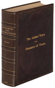
Hist. of Indian wars of the Far West - Massacres of the MountainsJasper524.5(9.8k)See Sold PriceFeb 27, 2024
W. R. Thrasher, Indian Paintbrushes Oil on CanvasDallas Auction Gallery4.5(124)See Sold PriceMar 05, 2024
A LARGE ERRATA BOOK INDIAN MAPS AND STUDIES including the provinces of Bengal, Cossimbuzar Island, THannam's Auctioneers Ltd4.3(386)See Sold PriceFeb 27, 2024
The Kingdom of Dalmatia Territories Map, 1700Antiques Online Auctions4.6(407)See Sold PriceMar 14, 2024