Sold17th Century Hemisphere Map[Hemisphae Alis Coeli Sphaeri Gra-RII Bore et Terrae Casceno Phia.,] signed and dated in plate "Henricus Hondius 1661" (Dutch, 1615-1676), publisher Petrum Schenk & Gerardum Valk, Amsterdam, 1661, hanSee Sold Price
SoldFour, Framed Maps of the WorldFour vintage color lithographs, maps of the world including global hemisphere map of 17th century by N. Visscher; The Holy Land from Abraham Ortelius, orig 1570 A.D; Canada and the Great Lakes, by GuiSee Sold Price
Nicolaes Visscher, Map of the World, 17th Century'Orbis Terrarum Tabula Recens Emendata et in Lucem Edita', 17th century map. Dutch bible double-hemisphere world map with allegorical figure scenes of Europe, Asia, Africa and America in the 4 cornersSee Sold Price
SoldAmericae Nova descriptio Impensis Anae seile 1663, 17thAmericae Nova descriptio Impensis Anae seile 1663, 17th century map of Western Hemisphere Ann Seila. sight size 13 1/2" x 16 1/2" Provenance: From an estate in Lloyd Harbor, Long Island, New YorkSee Sold Price
Sold17th Century Hondius World Map["Nova Totius Terrarum Orbis Geographica ac Hydrographica Tabula,"] by Henricus Hondius, originally published in the Mercator-Hondius atlas, Amsterdam, 1630 or later, double-hemisphere map with elaborSee Sold Price
SoldGerard Valck Double-Hemisphere World MapGerard Valck Double-Hemisphere World Mapcopperplate engraving, MAPPE MONDE GEO HYDROGRAPHIQUE DU GLOBE, Amsterdam, late 17th century, hand-colored with allegorical scenes depicting each of the four seSee Sold Price
SoldEARLY CELESTIAL MAP of the Hemisphere possiblyEARLY CELESTIAL MAP of the Hemisphere possibly 17th/18th century overall framed- 23" x 34 1/2"See Sold Price
SoldPlanisfero del Mondo Nuovo, Descritto…Vincenzo Coronelli (1650 – 1718). Venice, 1691, 20 x 28 inches. Italy’s Greatest 17th Century Map Maker. A very fine map of the Western Hemisphere including the discoveries made by Abel Tasman inSee Sold Price
Sold17th Century Schenck Map of theWestern Hemisphere [America Septentrionalis Novissima/America Meridionalis Accuratissima,] by Pieter Schenck, published in Amsterdam, circa 1695, North and South America, California depicted as an islSee Sold Price
17th Century Hondius Map of theWestern Hemisphere [Septentrio America,] by Jodocus Hondius, published in Amsterdam, first published 1606, from [Mercator's Atlas,] showing North and South America with various sailing vessels and seaSee Sold Price
SoldA Late 17th Century Map of Poland, Prussia, LithuaniaNicolaas Visscher after N. Sanson, c.1690, decorative cartouche showing two wind heads, a cheetah’s head and two sets of bows and arrows reads 'abula nova totius Regni Poloniae in quo sunt DucaSee Sold Price
SoldA 17th Century Map of Poland, lithuania, Ukraine,Johannes de Ram, c.1690, titled 'Regni Poloniae et Ducatus Lithuaniae Volhyniae, Podoliae, Ucraniae, Livoniae et Curlandiae, Descriptio, Ementata de Johannes de Ram', Copperplate engraving original unSee Sold Price
SoldA John Speed, 17th Century Map of Poland,Speed, John (1552-1629). 17th-Century map of Poland, hand-coloured copper engraving, featuring inset city views and figures displaying regional fashions/costumes, published by Bassett & Chiswell, EnglSee Sold Price
SoldA Large Scale 17th Century Map of Poland andSANSON, N and JAILLOT, A.H., Paris 1685, titled 'Les Estates de Couronnede de Pologne en leurs Palatinatsqui comprennet Le Royaume de Pologne, Le Grande Duche de Lithuanie', Large scale map of PolandSee Sold Price
Sold17th Century Map of the Southeast"[Virginiae partis australis, et Floridae partis orientalis…,]" by Willem Blaeu, after Mercator and Hondius, from Blaeu's [Theatre du Monde ou Nouvel Atlas,] Amsterdam, 1640, showing the coastline aSee Sold Price
Sold17th century map "Le Canada ou Nouvelle France", 17" x17th century map "Le Canada ou Nouvelle France", 17" x 23".See Sold Price
SoldAbraham Ortelius 17th Century Map of Turcici ImperiiAbraham Ortelius 17th Century Map of Turcici Imperii Descriptio 17''x22'' Sheet. Hand colored with text on verso. From the edition of ''Theatrum Orbis Terrarum''. Loose, unframed. Overall wear from agSee Sold Price
SoldHenricus Hondius 17th Century Map of Terra Firma etHenricus Hondius 17th Century Map of Terra Firma et Novum Regnum Gratense et Popayan 17.5''x22'' Sheet. Hand colored map of Central American with text on verso. Loose, unframed. Slight overall wear frSee Sold Price
SoldA 17th Century Map of Lithuania, Latvia, Poland,published c. 1662, Willem Janszoon Blaeu (1570–1630), cartouch reads 'Magni Ducatus Lithuaniae et Regionum Adiacentium exacta Descriptio . . . D.Nicolai Christopheri Radziwil . . .' detailed maSee Sold Price
SoldA 17th Century Map of Zamosc in Poland,Braun & Hogenberg, C.1618, titled 'Zamoscium. Nova Poloniae civitas, à magnifico eius regni Cancellaro à fundamentis exstructa', unusual birds-eye view of the walled city, with cartouchee to topSee Sold Price
SoldRare 17th Century Map: Nova Persiae Armeniae NatoliaeHand colored Cornelis Danckerts edition of this decorative and highly desireable map of the region bounded by the Saudi Peninsula, Red Sea, Nile River, Cyprus, Asia Minor, the Gulf of Aden, Indian OceSee Sold Price
SoldA 17th Century Map of Zamosc in Poland,C.1618, titled ‘Zamoscium. Nova Poloniae civitas, à magnifico eius regni Cancellaro à fundamentis exstructa’, unusual birds-eye view of the walled city, with cartouchee to top leftSee Sold Price
Sold17th Century Map of CarolinaA New Description of Carolina by the order of the Lord's Proprietors, John Ogilby, 1670, engraver James Maxon, double page laid paper with grape cluster watermark, includes hand-colored depictions ofSee Sold Price
Sold17th Century MapComittus Tirolean framed early map, size is 19 x 23 book leaf, double sidedSee Sold Price
17th Century Hand Colored Engraved Map of GermanyGlobal Auctions Company4.3(36)See Sold PriceMar 03, 2024
Willem Blaeu, Etc. 17th C. Antiquarian Maps, 2Auctions at Showplace4.6(731)See Sold PriceMar 17, 2024
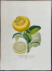
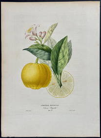
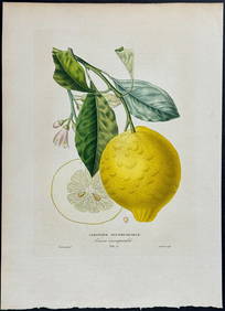
Risso - Lemon or Citrus Fruit. 73Trillium Antique Prints & Rare Books4.5(30)See Sold PriceFeb 24, 2024
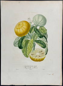
Risso - Lemon or Citrus Fruit. 71Trillium Antique Prints & Rare Books4.5(30)See Sold PriceFeb 24, 2024
WEST AFRICA Niger/Gambia rivers tribes towns. 'Pays des Negres'. MALLET 1683 mapJasper524.5(9.8k)See Sold PriceFeb 28, 2024
WEST AFRICA. Guinea. Nigeria Ghana Benin Togo Sierra Leone. MALLET 1683 mapJasper524.5(9.8k)See Sold PriceFeb 28, 2024
WEST CENTRAL AFRICA. Congo Angola Gabon Cameroon Sao Tome. MALLET 1683 old mapJasper524.5(9.8k)See Sold PriceFeb 28, 2024
NORTH AFRICA. 'Biledulgerid', a former North African country. MALLET 1683 mapJasper524.5(9.8k)See Sold PriceFeb 28, 2024
WEST AFRICA/MAGHREB Tribes Garamantes Getgulie 'Ancienne Libye'. MALLET 1683 mapJasper524.5(9.8k)See Sold PriceFeb 28, 2024
MALLET. Description de l'Univers. Africa. Volume 3 title page. MALLET 1683Jasper524.5(9.8k)See Sold PriceFeb 28, 2024
NORTH AFRICA. Barbary. Morocco Tunisia Libya Egypt. 'Barbarie'. MALLET 1683 mapJasper524.5(9.8k)See Sold PriceFeb 28, 2024
NORTH AFRICA. Morocco Tunisia Libya. 'Mauritanie'. Malta Melita. MALLET 1683 mapJasper524.5(9.8k)See Sold PriceFeb 28, 2024
NUBIA. 'Nubie'. Nile Valley. Sudan Ethiopia Egypt. MALLET 1683 old antique mapJasper524.5(9.8k)See Sold PriceFeb 28, 2024
SUB-SAHARAN AFRICA. 'Ancienne Ethiopie'. Ancient Ethiopia. MALLET 1683 old mapJasper524.5(9.8k)See Sold PriceFeb 28, 2024
JOHN LIGHTFOOT'S 1675 HORAE HEBRAICAE AND TALMUDICAE IS AN OLD JUDAICANY Elizabeth 4.3(85)See Sold PriceMar 03, 2024
ANTIQUE 1686 OPERA OMNIA BY JOHN LIGHTFOOT TELLIMA BOUND FOLIO WITH ISRAEL MAPNY Elizabeth 4.3(85)See Sold PriceMar 03, 2024
1675: ANTIQUE ILLUSTRATED JULIUS CAESAR MAPS OF ROMAN HISTORYNY Elizabeth 4.3(85)See Sold PriceMar 03, 2024
CURTIUS RUFUS QUINTUS, SIXTEENTH-CENTURY ELZEVIER HISTORIARUM LIBRI W/ MAP 16.33NY Elizabeth 4.3(85)See Sold PriceMar 03, 2024
Set of 6 Lithograph Prints of Dalarna Cabinets, Nordic Textiles, and Baroque Elegance - 1800sProverde Auctions4.3(3)See Sold PriceFeb 28, 2024