SoldTransitional map of U.S. West 1858Title: Oregon, Washington, California, Utah and New Mexico Author: Colton, J.H. Description: Lithographed map, hand-colored. 33x27 cm. (13x10½").Transitional map of the American West, with Oregon andSee Sold Price
Sold2 maps: ''Rio Colorado of the West'' 1858, pub. 1[Western US]. 2 Maps. Explorations And Surveys. War Department. Map Nos. 1-2. Rio Colorado Of The West. Drawn by F. W. von Egloffstein. 1858. From: Report Upon The Colorado River Of The West, ExploredSee Sold Price
Map of U.S. & Mexico 1858Title: Mexique Antilles et Californie Author: Dufour, Adolphe Hippolyte Description: Engraved map, hand-colored. 55x74 cm. (21½x29").Includes the West Indies & most of the United States, with pre-GadSee Sold Price
SoldMap of U.S. & Mexico 1858Title: Mexique Antilles et Californie Author: Dufour, Adolphe Hippolyte Description: Engraved map, hand-colored. 55x74 cm. (21½x29").Includes the West Indies & most of the United States, with pre-GadSee Sold Price
Sold1873 Skeleton Map US Territory West of Missisippi"Skeleton Map Of the Territory of the United States west of the Mississippi River Exhibiting the Relations Existing Between Lines And Areas Of Explorations & Surveys Conducted under the auspices of thSee Sold Price
SoldItalian map of U.S. West with gold region 1851Heading: Author: Marzolla, B[enedetto] Title: Nuova California (Stati Uniti dell'America Settentrionale) Place Published: [Naples] Publisher: Date Published: 1851 Description: LSee Sold Price
1863 Johnson Map of US West -- Johnson's California Territories of New Mexico Arizona ColoradoTitle: 1863 Johnson Map of US West -- Johnson's California Territories of New Mexico Arizona Colorado Nevada and Utah Cartographer: Johnson & Ward Year / Place: 1863, New York Map Dimension (in.): 17.See Sold Price
Sold1847 map of U.S. WestTitle: Western Territories of the United States Author: Robinson, D. E. Description: Engraved map, hand-colored. 27x44 cm. (10¾x17¼"), plus margins.Interesting map of the Northwest U.S. up to the "BSee Sold Price
Sold1847 map of U.S. WestTitle: Western Territories of the United States Author: Robinson, D. E. Description: Engraved map, hand-colored. 27x44 cm. (10¾x17¼"), plus margins.Interesting map of the Northwest U.S. up to the "BSee Sold Price
1864 Johnson Map of US West -- Johnson's California, with Utah, Nevada, Colorado, New Mexico, andTitle: 1864 Johnson Map of US West -- Johnson's California, with Utah, Nevada, Colorado, New Mexico, and Arizona Cartographer: Johnson and Ward Year / Place: 1864, New York Map Dimension (in.): 16.9 XSee Sold Price
Italian map of U.S. West with gold region 1851Heading: Author: Marzolla, B[enedetto] Title: Nuova California (Stati Uniti dell'America Settentrionale) Place Published: [Naples] Publisher: Date Published: 1851 Description: <See Sold Price
Italian map of U.S. West with gold region 1851Heading: Author: Marzolla, B[enedetto] Title: Nuova California (Stati Uniti dell'America Settentrionale) Place Published: [Naples] Publisher: Date Published: 1851 Description: <See Sold Price
Map of United States, 1832Map: United States Maker: Anonymous Date: 1832 Size: Double Quarto, 10.3 inches high x 17.5 inches wide Map showing U.S. west to Rocky Mountains. Includes Texas (w/Galvezton far inland), lg. MissouriSee Sold Price
SoldMap of the United States 1835Map: Map of the United States Maker: Anonymous Size: Folio - 11.2 inches high x 14.6 inches wide Date: 1835 Map covering U.S. west to Rocky Mtns. Large NW Terr.; huge MO Terr. Texas part of Mexico asSee Sold Price
SoldUnited StatesReserve Reduced! Title: United States Publication Date: 1832 Cartographer: KNIGHT, J. Publisher: KNIGHT, J. Size (inches): H5.3 - W6.3 Frontispiece for Darby Travel Book. Map of U.S. west to Mandan, SSee Sold Price
Sold1882 Map of the US West CoastTitle: 1882 Map of the US West Coast Medium: Ink on Paper Dimensions: 21"X15" Description: Map of US West Coast dated 1882. Part of the Comprehensive Atlas & Geography of the World. Engraved by J. W.See Sold Price
Magini: Antique Map of Asia & U.S. West Coast, 1598Map: Asia and U.S. West Coast- Tartariae Imperium - "Descrittione del Potentissimo Imperio della Tartaria - Tartariae Imperium " Date Printed: 1598 Cartographer: Giovanni Antonio Magini Size: 7 x 5 inSee Sold Price
Sold1832 map showing U.S. expansion westHeading: (United States) Author: Tasso, G. Title: Stati-Uniti dell' America Settentrionale dalle Piu Recenti Mappe... Place Published: Venice Publisher: Date Published: 1832 DescriptionSee Sold Price
SoldMitchell's New National Map of the U.S. 1858with British Provinces, engraved by W. Williams, published by S. Augustus Mitchell, Phila. 62" x 62" Condition damage along entire top ofSee Sold Price
1864 Johnson Map of Evolving US West -- Johnson'sTitle: 1864 Johnson Map of Evolving US West -- Johnson's California, with Utah, Nevada, Colorado, New Mexico, and Arizona Cartographer: Johnson & Ward Year / Place: 1864, New York Map Dimension (in.):See Sold Price
SoldItalian map of American West 1858Title: Stati E Territorii Occidentali Della Unione Americana Author: Marmocchi, Francesco Costantino Description: Engraved map, hand-colored. 33x27.5 cm. (13x10¾").Rare and very interesting map fromSee Sold Price
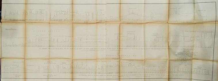
1855 Beckwith Profile Map of the US West -- Profiles from Explorations and Surveys… No 1 RouteTitle: 1855 Beckwith Profile Map of the US West -- Profiles from Explorations and Surveys… No 1 Route Near the 41st Parallel… No2 2 Route Near the 38th Parallel Cartographer: E Beckwith DaSee Sold Price
Italian map of American West 1858Title: Stati E Territorii Occidentali Della Unione Americana Author: Marmocchi, Francesco Costantino Description: Engraved map, hand-colored. 33x27.5 cm. (13x10¾").Rare and very interesting map fromSee Sold Price
Sold1858 US Coast Survey Map of Charleston Harbor --Title/Content of Map: 1858 US Coast Survey Map of Charleston Harbor -- Preliminary Chart of Charleston Harbor and Its Approaches from a Trigonometrical Survey Under the Direction of A.D. Bache… CartSee Sold Price
Central Railroad of New Jersey Map of Sandy Hook Route-ca. 1903JM Hobby Supply and Railroad Artifact Auctions4.4(127)See Sold PriceFeb 24, 2024
Map of Part of the West Indies, Etc., Showing the Exact Position Of The U.S. War Steamer SanJasper524.5(9.9k)See Sold PriceFeb 27, 2024
WEST AFRICA Explorers' routes Senegal Ashanti. Mountains of Kong. SDUK 1857 mapJasper524.5(9.9k)See Sold PriceFeb 28, 2024
West Africa by Arrowsmith & Lewis 1812 old antique vintage map plan chartJasper524.5(9.9k)See Sold PriceFeb 28, 2024
AFRICA. Map pre-dating much exploration. Mountains of Kong. SDUK 1851 oldJasper524.5(9.9k)See Sold PriceFeb 28, 2024
CAP VERT. French/Portuguese Guinea Gambia Senegal Sierra Leone 1947 old mapJasper524.5(9.9k)See Sold PriceFeb 28, 2024
Colonial & French West Africa. Gold Coast Dahomey Upper Volta. TIMES 1922 mapJasper524.5(9.9k)See Sold PriceFeb 28, 2024
Colonial West Africa. Nigeria Cameroon Congo. British German. TIMES 1900 mapJasper524.5(9.9k)See Sold PriceFeb 28, 2024
Cooke, George 1801 Antique Map. West Indies CaribbeanAlbion Auctions4.6(341)See Sold PriceMar 01, 2024
Blackie (Pub) 1882 Folio Map. West USA - Pacific StatesAlbion Auctions4.6(341)See Sold PriceMar 01, 2024
Blackie (Pub) 1882 Folio Map. West India Islands & Central AmericaAlbion Auctions4.6(341)See Sold PriceMar 01, 2024
West Coast U.S. Vintage Travel Maps, Brochures 46Grant Zahajko Auctions, LLC4.7(1k)See Sold PriceMar 06, 2024