SoldA New and Correct Map of Scotland drawn from the lA New and Correct Map of Scotland drawn from the latest Surveys of that Part of Great Britian - 14 1/2" x 9 1/4"See Sold Price
SoldEnglish School: A New and Correct Map of ScotlandEnglish School: A New and Correct Map of Scotland Engraving in black with hand-coloring on laid paper, 1794, published by Laurie & Whittle, London. 50 x 42 in. (sight), 52 1/2 x 44 1/2 in. (frame).See Sold Price
Campbell (Lieut. R) Scotland, North BritainCampbell (Lieut. Robert) A New and Correct Map of Scotland, or North Britain,with all the Post and Military Roads, Divisions & ca., large title cartouche, upper left, inset map of the ShetlandSee Sold Price
Campbell (Lieut. Robert) ScotlandCampbell (Lieut. Robert) A New and Correct Map of Scotland, or North Britain,with all the Post and Military Roads, Divisions &ca., large title cartouche, upper left, inset map of the ShetlandSee Sold Price
SoldCampbell (Lieut. Robert) Map of ScotlandScotland.- Campbell (Lieut. Robert) A New and Correct Map of Scotland or North Britain, with all the Post and Military Roads, Divisions &ca., engraved map on 4 sheets, joined, with original haSee Sold Price
SoldBowen: Antique Map of France, 1768Title/Content of Map: 1768 Bowen Map of France -- A New and Correct Map of France Drawn from the latest Authorities Date Printed: 1768 c. Cartographer: T Bowen Size: 14.3 x 9.3 in. Condition: Fair. NiSee Sold Price
"A new & correct map of the North part of Scotland" byTITLE/CONTENT OF MAP: 13871: 201: 'A new & correct map of the North part of Scotland from the best authorities' DATE PRINTED: 1805 IMAGE SIZE: Approx 44.0 x 55.0cm, 17.25 x 21.75 inches (Large); PleasSee Sold Price
"A new & correct map of the South part of Scotland" byTITLE/CONTENT OF MAP: 'A new & correct map of the South part of Scotland from the best authorities' DATE PRINTED: 1789 IMAGE SIZE: Approx 41.0 x 54.0cm, 16.25 x 21.25 inches (Large); Please note thatSee Sold Price
A new & correct map of the South part of Scotland byReserve Reduced! TITLE/CONTENT OF MAP: 'A new & correct map of the South part of Scotland from the best authorities' The top image on the right hand side shows the entire map. To view a close up of thSee Sold Price
A new & correct map of the North part of Scotland byReserve Reduced! TITLE/CONTENT OF MAP: 13871: 201: 'A new & correct map of the North part of Scotland from the best authorities' The top image on the right hand side shows the entire map. To view a clSee Sold Price
SoldDetailed map of Scotland 1747Heading: Author: Bowen, Emanuel Title: A New & Accurate Map of Scotland or North Britain. drawn from surveys and most approved Maps and Charts... Place Published: London Publisher: Date PublisheSee Sold Price
SoldCARY (JOHN), A NEW & CORRECT MAP OF THE NORTH PART OFCARY (JOHN), A NEW & CORRECT MAP OF THE NORTH PART OF SCOTLAND FROM THE BEST AUTHORITIES, engraved map with hand colouring, framed. 41.5cm by 53cmSee Sold Price
SoldCARY (JOHN), A NEW & CORRECT MAP OF THE NORTH PART OFCARY (JOHN), A NEW & CORRECT MAP OF THE NORTH PART OF SCOTLAND FROM THE BEST AUTHORITIES, engraved map with hand colouring, framed. 41.5cm by 53cmSee Sold Price
Sold'A New And Correct Map Of The South Part Of SCOTLAND'A New And Correct Map Of The South Part Of SCOTLAND from the beft Authorities' engraved by John Cary (c. 1754 – 1835) was an British cartographer. Condition Report: Prior to bidding, please consultSee Sold Price
SoldENGLISH MAP OF THE UNITED PROVINCES EMANUEL BOWENENGLISH MAP OF THE UNITED PROVINCES, EMANUEL BOWEN, H 14" W 17":Inscribed at the upper right, "A New and Correct Map of the Seven United Provinces, Drawn from the most Approved Maps and Charts: the WhSee Sold Price
ENGLISH MAP OF THE UNITED PROVINCES EMANUEL BOWENENGLISH MAP OF THE UNITED PROVINCES, EMANUEL BOWEN, H 14" W 17":Inscribed at the upper right, "A New and Correct Map of the Seven United Provinces, Drawn from the most Approved Maps and Charts: the WhSee Sold Price
1784 Bowen Map of Greater London -- A New & Correct MapTitle/ Content of Map: 1784 Bowen Map of Greater London -- A New & Correct Map of the Counties upwards of Twenty Miles Round London, Drawn from Modern Surveys and Engrav'd for Thornton's History of LoSee Sold Price
1784 Bowen Map of Greater London -- A New & Correct MapTitle: 1784 Bowen Map of Greater London -- A New & Correct Map of the Counties upwards of Twenty Miles Round London, Drawn from Modern Surveys and Engrav'd for Thornton's History of London &c. Date: 1See Sold Price
1784 Bowen Map of Greater London -- A New & Correct MapTitle/Content of Map: 1784 Bowen Map of Greater London -- A New & Correct Map of the Counties upwards of Twenty Miles Round London, Drawn from Modern Surveys and Engrav'd for Thornton's History of LonSee Sold Price
E. Bowen. New & correct map of Southwest of GermanyBowen, Emanuel A new and correct map of South West part of Germany C. 1745 Copperplate engraving; uncoloured Printed area: 34.5 x 42 cm; 13.5 x 16.5 in This map, drawn with the utmost sense of precisiSee Sold Price
1784 Bowen Map of Greater London -- A New & Correct MapTitle/Content of Map: 1784 Bowen Map of Greater London -- A New & Correct Map of the Counties upwards of Twenty Miles Round London, Drawn from Modern Surveys and Engrav'd for Thornton's History of LonSee Sold Price
1784 Bowen Map of Greater London -- A New & Correct MapTitle: 1784 Bowen Map of Greater London -- A New & Correct Map of the Counties upwards of Twenty Miles Round London, Drawn from Modern Surveys and Engrav'd for Thornton's History of London &c. Date: 1See Sold Price
1784 Bowen Map of Greater London -- A New & Correct MapTitle: 1784 Bowen Map of Greater London -- A New & Correct Map of the Counties upwards of Twenty Miles Round London, Drawn from Modern Surveys and Engrav'd for Thornton's History of London &c. Date: 1See Sold Price
1784 Bowen Map of Greater London -- A New & Correct MapTitle: 1784 Bowen Map of Greater London -- A New & Correct Map of the Counties upwards of Twenty Miles Round London, Drawn from Modern Surveys and Engrav'd for Thornton's History of London &c. CartogrSee Sold Price
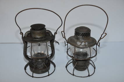
Two Switchmans Lanterns-CCCSTL RR and New York Central RR-Dietz/AdlakeJM Hobby Supply and Railroad Artifact Auctions4.4(127)See Sold PriceFeb 24, 2024
LATE 17TH C. FRENCH MAP OF THE NEW WORLD BY ALEXIS-HUBERT JAILLOT (1632-1712)Thomaston Place Auction Galleries4.4(393)See Sold PriceFeb 24, 2024
Vintage County Map Of NY State Plate EngravingThe Benefit Shop Foundation Inc.4.3(2.9k)See Sold PriceFeb 28, 2024
Portfolio of 15 County Maps by Robert Morden (English 1650-1703)Nadeau's Auction Gallery4.7(409)See Sold PriceFeb 24, 2024
Pair of The Gateway to a Continent Books - Grand Central Zone and 1939 World's FairRail & Road Auctions4.6(165)See Sold PriceMar 07, 2024
Three Walter L. Green New York Central Framed Advertising Prints - "In The Hudson River Valley" ,Rail & Road Auctions4.6(165)See Sold PriceMar 08, 2024
1919 The Story of The Great War by Official Sources Volumes 1,2,3,8.North American Artifact Auctions4.7(198)See Sold PriceApr 20, 2024
Chatelain - 3 Maps of the British Isles (England, Ireland, Scotland)Trillium Antique Prints & Rare Books4.5(32)See Sold PriceFeb 24, 2024
D'Entrecasteaux - Map of Australia (New Holland), New Zealand, and southern Asia and surroundingTrillium Antique Prints & Rare Books4.5(32)See Sold PriceFeb 24, 2024
STAR WARS: A NEW HOPE (1977) - Framed Hand-Drawn Joe Johnston Docking Bay StoryboardPropstore4.2(6)See Sold PriceMar 13, 2024
New and Correct Map of North America With the West India Islands,Jasper524.5(9.9k)See Sold PriceFeb 27, 2024
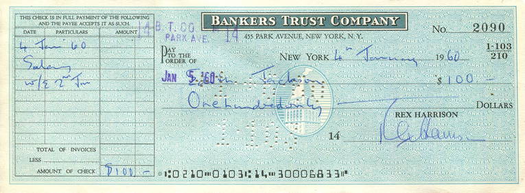
HARRISON REX: (1908-1990)International Autograph Auctions Europe S.L.4.4(52)See Sold PriceMar 13, 2024
WESTWOOD VIVIENNE: (1941-2022)International Autograph Auctions Europe S.L.4.4(52)See Sold PriceMar 13, 2024
JAMES P. D.: (1920-2014)International Autograph Auctions Europe S.L.4.4(52)See Sold PriceMar 14, 2024
Robert de Vaugondy - Map of Canada - Mer de l' Ouest or Sea of the West and a Northwest PassageProverde Auctions4.3(3)See Sold PriceFeb 28, 2024
Jules Verne, L'Archipel en Feu, Au Steamer Red MacaronLion and Unicorn4.8(1.9k)See Sold PriceMar 10, 2024
Hudson River Map & North American Postcards, 45Auctions at Showplace4.6(740)See Sold PriceFeb 13, 2025