SoldMorden (Robert) The Kingdom of IrelandMorden (Robert) The Kingdom of Ireland,title cartouche, upper left, engraved map with hand-colouring, 420 x 350mm, central horizontal fold, sold by Awnsham and Churchill, c.1695 or later.See Sold Price
SoldMorden (Robert) The Kingdom of IrelandMorden (Robert) The Kingdom of Ireland,engraved map with hand-colouring, 415 x 350mm, central horizontal fold, minor surface dirt, Abel Swale, Awnsham and John Churchill, [1695 or later].See Sold Price
SoldHandcolored Map of IrelandMorden, Robert - The Kingdom of Ireland handcolored map, Abel Swale, Awnsham and John Churchill (1695 or later) mounted in a maple frame 17.5"h 14.5"d sight size / 19" x 16" overall Condition: creasedSee Sold Price
SoldRobert MORDEN The Kingdom of IrelandA map of the Kingdom of Ireland, taken from Camden's Britannia. Published by Edmund Gibson, 1695. Coloured. 38 cm. wide; 46 cm. high. Abl 42. A few small marks, otherwise good clean copy. (1).See Sold Price
SoldThe Kingdom of Ireland by Robert MordenThe Kingdom of Ireland by Robert Morden. hand colored engraving. Sight: 16 3/4 x 14 inches. Signed in image upper left: By Rob Morden. (Note: with Certificate and sales reciept from Harrods of London.See Sold Price
THE KINGDOM OF IRELAND by ROBERT MORDEN from Camden's Britannia 1722 old mapTitle: THE KINGDOM OF IRELAND by ROBERT MORDEN from Camden's Britannia 1722 old map Description: The Kingdom of Ireland' by Robert Morden; "Sold by Abel Swale Awnsham & Iohn Churchill [John Churchill]See Sold Price
THE KINGDOM OF IRELAND by ROBERT MORDEN from Camden's Britannia 1695 old mapTitle: THE KINGDOM OF IRELAND by ROBERT MORDEN from Camden's Britannia 1695 old map Description: The Kingdom of Ireland' by Robert Morden; "Sold by Abel Swale Awnsham & Iohn Churchill [John Churchill]See Sold Price
SoldAntique hand coloured map ' The Kingdom of Ireland ' byAntique hand coloured map ' The Kingdom of Ireland ' by Robert Morden, 17ins x 14insSee Sold Price
Sold18th Century Robert Morden map of the Kingdom of18th Century Robert Morden map of the Kingdom of Ireland PROVENANCE: From a private family collection built up over many years in Weybridge. 16 x 13in. (41 x 33cm)See Sold Price
SoldMorden (Robert) - A group of English county maps,including Lancaster, Cornwall; Berkshire, The Kingdom of Ireland, 27 engraved maps, first edition, soiled and stained, tears along central vertical fold, chipped at edges, each c.370 x 440 mm., Abel SSee Sold Price
1760 map of Ireland, engraved, hand-col1760 map of Ireland, engraved, hand-colored in outline, four sheets in two sections, "A Map of the Kingdom of Ireland," Robert Sayer, London, tears and toning, unframed, 51-1/4 x 39"See Sold Price
SoldA set of 7 various maps including: (i) A map of theA set of 7 various maps including: (i) A map of the County of Dublin Divided in Baronys By John Rogue, 43x 64cm (ii) The kingdom of Ireland bu Robt. Morden, 42 x 36cm (iii) Europa, by Guilielmo BlaeuwSee Sold Price
SoldBSCOT Morden (Robert) ScotlandBSCOT Morden (Robert) Scotlandmap of Scotalnd, including the Inner and Outer Hebrides, Orkney Islands, and part of Ireland, decorative title cartouche, upper left, Dieu et mon droit motto, uppSee Sold Price
SoldMorden (Robert) EnglandMorden (Robert) England,map of England and Wales, with the coastlines of parts of Scotland, Ireland and Flanders, decorative title cartouche, upper right, engraved map with outline hand-colourSee Sold Price
Sold1680 MORDEN ROBERT (1650 - 1703) INCISIONE in bianco e1680 MORDEN ROBERT (1650 - 1703) INCISIONE in bianco e nero "Sicilia" (cm 11,5 x 13,5) tratta dal libro Geography rectified: or a description of the world in all its kingdom, provinces, countries, islSee Sold Price
SoldScotland.- Morden (Robert) - Scotland,including the Inner and Outer Hebrides, Orkney Islands, and part of Ireland, decorative title cartouche upper left, royal arms upper right, engraved map with hand-colouring, 445 x 355mm., central horSee Sold Price
SoldAntique handcoloured map of Ireland, together withAntique handcoloured map of Ireland, together with another similar by Robert MordenSee Sold Price
SoldThree 18th and 19th c. maps, Ireland and UK(Lot of 3) Framed 18th and 19th century maps, ''Buckingham Shire'' by Robert Morden, ''Seven United Provinces'' by Eman Bowen, and ''Ireland'' by Herman Moll 1732, largest overall: 19.5''h x 22''wSee Sold Price
SoldMAP OF THE KINGDOM OF IRELAND BY J. ROCQUE, LONDONMAP OF THE KINGDOM OF IRELAND BY J. ROCQUE, LONDON printed for Robert Sayer, Fleet Street, framed 38.5in (98cm)h x 48.5in (123cm)w. (1)See Sold Price
SoldIreland - Roque, John 1762 Large Rare Wall Map"A Map of the Kingdom of Ireland Divided into Provinces, Counties and Baronies" Large Copper Engraved Map with original hand colour. Published 1762 by Robert Sayer. 4 Joined Sheets to form one large mSee Sold Price
"Royaume d'Irlande divisé en ses quatre provinces".TITLE/CONTENT OF MAP: 'Royaume d'Irlande divisé en ses quatre provinces, et subdivisé en Comtés, par le Sr. Robert. À Venise par P. Santini 1778. Chez Mr. Remondini [Kingdom of Ireland divided intSee Sold Price
SoldBook: Hibernian AtlasBook: Hibernian Atlas General description of the Kingdom of Ireland, Bernard Scale, Printed for Robert Sayer and John Bennett, Map and Print Fellers, no.53 Fleet street, London Worldwide shipping avaiSee Sold Price
LARGE Robert Waltsak (NJ,b 1944) oil paintingBroward Auction Gallery4.8(285)See Sold PriceMar 10, 2024
Robert William Wood (1889 - 1979) Texas BluebonnetsPremier Auction Galleries4.3(329)See Sold PriceMar 09, 2024
RAPP, Augustus (1871 – 1961). The Life and Times of Augustu...Potter & Potter Auctions4.6(544)See Sold PriceFeb 24, 2024
Portfolio of 15 County Maps by Robert Morden (English 1650-1703)Nadeau's Auction Gallery4.7(405)See Sold PriceFeb 24, 2024
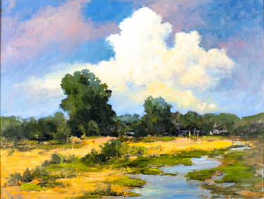
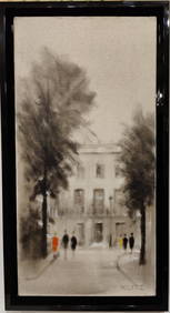
Tony Klitz O/C European Modernist Architectural LandscapeHeritage Gallery Auctions4.4(56)See Sold PriceMar 10, 2024
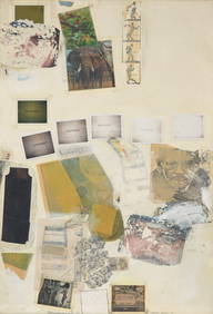
Robert Rauschenberg (American, 1925-2008) - Letter Head IIFreeman's | Hindman4.5(158)See Sold PriceFeb 27, 2024
5 Hardback Books on Birds, Animals & Nature all in Excellent condition.North American Artifact Auctions4.6(184)See Sold PriceApr 20, 2024
1890 United Kingdom Cover Dublin Ireland to Ohio OH USAMynt Auctions4.6(689)See Sold PriceFeb 25, 2024
A mid 20thC Union flag / Union Jack / Flag of the United Kingdom of Great Britain and NorthernClaydon Auctioneers Ltd4.3(125)See Sold PriceFeb 26, 2024
Map: An 18thC engraved and hand coloured map of Buckinghamshire after Robert Morden. Approx. 8 1/4"Claydon Auctioneers Ltd4.3(125)See Sold PriceFeb 26, 2024
Map: A 17thC engraved and hand coloured map of Bedfordshire after Robert Morden. Approx. 12 1/2" xClaydon Auctioneers Ltd4.3(125)See Sold PriceFeb 26, 2024
Cokayne (George Edward) The Complete Peerage, of England, Scotland, Ireland, Great Britain and TheForum Auctions4.3(53)See Sold PriceFeb 29, 2024
LUBA Kibango Chief's Staff Scepter Congo Drc African Tribal Art Regalia 1282Jasper524.5(9.8k)See Sold PriceFeb 27, 2024
William Bromley III (NJ,Irish,UK,1835-1888) oil painting antiqueBroward Auction Gallery4.8(285)See Sold PriceMay 19, 2024
An Iran Persian Royal 25 years Military service Bronze Medal, Pahlavi EraAntique Kingdom4.1(21)See Sold PriceMar 08, 2024
PAIR OF MONUMENTAL HENRY DASSON FIGURAL TORCHIERE LAMPAntique Kingdom4.1(21)See Sold PriceMar 08, 2024
Antiquarian Science Book 17th Century Robert BoyleWillow Auction House4.5(284)See Sold PriceMar 14, 2024