SoldMAP: (on 2) BOSTON and NEW ENGLANDA New and Correct Plan of the Town of Boston; and Carte de la Baye de Baston, Situee dans la Nouvelle Angleterre each 10.75 by 8 in. (sight), mounted as one, matted, framed under glassSee Sold Price
SoldPOWNALL 1761 VIEW AND BURGIS MAP OF BOSTON (LOT OF 2).After Thomas Pownall (1722-1805), "A View of the City of Boston the Capital of NEW ENGLAND, in North America. Drawn on the Spot by his Excellency Governor Pownal. 1757", platemark: 9 3/4 x 21 inches;See Sold Price
SoldRailroad Public Travel Folders & Booklets (15)Some interesting public travel information including a 1889 Boston & Maine "Here and There in New England & Canada", with 2 fold out maps. Mt Tom, B&M, "Charles to the Hudson" has Fitchburg Division sSee Sold Price
SoldB&M & Eastern Railroad Annual PassesA pair of New England Railroad passes: (1) Boston & Maine 1875 - fancy vignette of locomotive (2) Eastern Railroad 1873 with map to the Maritimes on the reverse.See Sold Price
SoldBoston.4 folding lithograph maps, as listed below.Boston.4 folding lithograph maps, as listed below. First 2 folding into original 8vo printed wrappers (first detached); last with tears along several folds, generally clean and sound. Boston, vdBird'sSee Sold Price
Sold1853 Boynton Map of Boston [verso] Map of New EnglandTitle: 1853 Boynton Map of Boston [verso] Map of New England -- New Map of Boston, Comprising the Whole City, with the New Boundaries of the Wards… [verso] Map of New England Exhibiting the Rail RoaSee Sold Price
SoldBoston / New England Almanac Maps by Boynton(1) 1844 "Plan of the City of Boston". Engraved by George W. Boynton. Printed by Samuel N. Dickinson. Good condition; tape repair to reverse, loss along bottom margin, age toning, etc. Folds as issuedSee Sold Price
SoldTicknor's New England 1888 Traveller's Guide bookTicknor's New England 1888 Traveller's Guide book has maps and advertising of various Boston, New England businesses, red binding w/ gold lettering, some wear to binding, maps are dog-eared and torn cSee Sold Price
SoldGrp: 2 Early Maps of New England de Vaugondy HomaGroup of two early maps of New England or the eastern seaboard of what is now the United States. Includes Robert de Vaugondy (1688–1766), "Partie de L'Amerique Septentrionale, qui comprend le CSee Sold Price
SoldAnnual Passes from New England B&M, CV, Fitch, MCA group of 5 passes dating from 1894, all are New England: (1) Boston & Maine (2) Central Vermont (3) Fitchburg “Hoosac Tunnel Route” (4) Maine Central with huge date on reverse (5) New York & NewSee Sold Price
SoldNorthern sheet of a 2-sheet map of New England.[New England] Northern sheet of a 2-sheet map of New England, 1760 or later. Includes a printed notice related to areas that are now part of Vermont: “Note/ Connecticut River is fixed by his MajestySee Sold Price
Sold1776 Accurate Map of Country Round BostonAccurate Map of the Country Round Boston in New England with inset "A Plan of Boston and Charlestown from Drawing Made in 1771". Published by A, Hamilton, January 16, 1776 for the Town and Country MagSee Sold Price
SoldNew England Railroad Public TimetablesA group of 7 older timetables from New England: 1880 Housatonic, 1883 Connecticut River (2), Boston Concord & Montreal 1871, Maine Central 1889 & 1894, Fitchburg 1884, condition varies, some old tapeSee Sold Price
SoldNew England Annual Passes (5)A group of 5 New England annual passes: (1) Portland & Ogdensburg (pre Maine Central) 1876 - excellent (2) Boston & Lowell 1886 - glue back (3) Concord Railroad 1876 - Very Good (4) Boston & ProvidencSee Sold Price
Sold1889 New England Magazine 2 VolumesNew England Magazine an Illustrated Monthly. Published by Boston: New England Magazine Corporation. Publication dates are November 1889 and July 1891. They are still in fairly good condition for softbSee Sold Price
Sold3 Brass Baggage Tags: P Stm Pkt, B&M, Conn RivA group of 3 baggage tags from New England: (1) Portland Steam Packet Company with Maine Central #690 (2) Boston & Maine "Way" #59025 (3) Springfield to Chicopee on the Connecticut River Railroad - reSee Sold Price
1722 Bonner Map of Boston Reproduction (1835)1722 Bonner Map of Boston Reproduction -- The Town of Boston in New England Bonner, 1835, This a grand, very early map of Boston, showing a great deal of detail, naming streets, parks, important buildSee Sold Price
SoldRailroad Timetables (4) 1883-18954 early public timetables: (1) New York & New England 11/15/1891 6 panel folder with fancy graphics (2) Boston & Maine 6/18/1883 8 panel folder meat and potatoes (3) Old Colony Suburban 11/18/1895 (4)See Sold Price
SoldAnnual Passes: T&B C&M (2)2 railroad passes from New England: (1) Troy & Boston 1880 - stain (2) Cheshire & Monadnock 1883 - trimmed cornersSee Sold Price
SoldDumont D'Urville, Jules S. C37. Dumont D'Urville, Jules S. C.Voyage Pittoresque Autour du Monde. Profusion of plates (some browned), 6 folding maps. 2 volumes. 4to, contemporary gilt-lettered calf-backed boards; some foxing, a fSee Sold Price
Sold(on 2) 18TH C. MASSACHUSETTS-BAY HISTORICAL BOOKThe Charter Granted by Their Majesties King William and Queen Mary to the Inhabitants of the Province of the Massachusetts-Bay in New-England, Boston, in New England printed by S.Kneeland, 1759; withSee Sold Price
Sold1835 PRINTING OF A 1722 BOSTON MAP BY JOHN BONNERTHE TOWN OF BOSTON IN NEW ENGLAND BY CAP'T JOHN BONNER, 1722 (THIS IS A REPRINT FROM 1835) ; 19 3/4" X 25 3/4" IMAGE UNDER GLASS IN WOOD FRAME; SOME STAINING AND SEVERAL TEARS , MOSTLY ON LEFT SIDESee Sold Price
SoldBonner Map of Boston 1835 VersionJohn Bonner engraving on paper of the Town of Boston in New England, reproduced by George G Smith in 1835. The print features one of the earliest maps of Boston with a strong, clear plate mark. DimensSee Sold Price
SoldThe Town of Boston in New Englandby Capt. John Bonner, 1835 engraved from a copy in the possession of Wm. Taylor Esq. and published by George G. Smith, engraver, 21-1?2 x 27-1?4 in. (sight); black frame good condition only with foxinSee Sold Price
Chicago Milwaukee and St Paul RY Freight Tariff Poster-March 20, 1879JM Hobby Supply and Railroad Artifact Auctions4.4(126)See Sold PriceFeb 24, 2024
1849 THE NEW-ENGLAND MERCANTILE UNIONNorth American Artifact Auctions4.6(182)See Sold PriceApr 20, 2024
[MAP]. [ALBRIZZI, Giambatista, 1698-1777]. Carta Geografica...Potter & Potter Auctions4.6(539)See Sold PriceMar 07, 2024
[ENSLAVEMENT & ABOLITION]. Circular of Information for the New England Freedmen's Aid Society.Freeman's | Hindman4.4(1.6k)See Sold PriceFeb 27, 2024
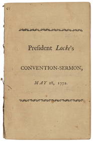
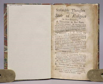
1743 SEASONABLE THOUGHTS ON STATE OF RELIGION IN NEW-ENGLAND antique AMERICANAJasper524.5(9.8k)See Sold PriceFeb 27, 2024
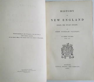
1865 HISTORY OF NEW ENGLAND by J. PALFREY Vol. III antiqueJasper524.5(9.8k)See Sold PriceFeb 27, 2024
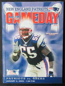
2005 1/2 New England Patriots vs. SF 49ers Game Program Tom Brady 176283Mynt Auctions4.6(680)See Sold PriceMar 01, 2024
100th Anniversary American Numismatic Association MedalRapid Estate Liquidators and Auction Gallery4.5(1.1k)See Sold PriceFeb 24, 2024
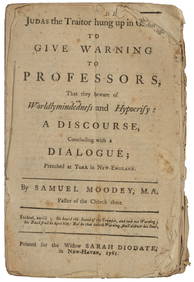
ANTIQUE AMERICANA, 1743: SEASONABLE THOUGHTS ON THE STATE OF RELIGION IN NEW ENGLANDNY Elizabeth 4.3(84)See Sold PriceMar 03, 2024
Herman Moll A New Map of Ye North Parts of AmericaWillow Auction House4.5(283)See Sold PriceMar 14, 2024
2 Drawer New England Blanket ChestM.J. Stasak Jr. Auction and Appraisal Service4.8(2.1k)See Sold PriceMar 10, 2024


![1853 Boynton Map of Boston [verso] Map of New England (1 of 2)](https://p1.liveauctioneers.com/5584/190355/95871630_1_x.jpg?height=282&quality=70&version=1609884614)


![[MAP]. [ALBRIZZI, Giambatista, 1698-1777]. Carta Geografica... (1 of 1)](https://p1.liveauctioneers.com/928/318880/171361280_1_x.jpg?height=282&quality=70&version=1707501302)
![[ENSLAVEMENT & ABOLITION]. Circular of Information for the New England Freedmen's Aid Society. (1 of 2)](https://p1.liveauctioneers.com/197/319238/171468081_1_x.jpg?height=282&quality=70&version=1707520367)