[WESTERN MAP] Johnson's 1858 Pocket Map of Missouri[WESTERN MAP] Johnson's 1858 Pocket Map of Missouri and Kansas . Johnson's New Rail-Road & Township Copper Plate Map of Missouri and Kansas, New York: A.J. Johnson and Chicago: Rufus Blanchard. 19.75See Sold Price
[WESTERN MAP] Johnson's 1858 Pocket Map of Missour[WESTERN MAP] Johnson's 1858 Pocket Map of Missouri and Kansas Johnson's New Rail-Road & Township Copper Plate Map of Missouri and Kansas, New York: A.J. Johnson and Chicago: Rufus Blanchard. 19.75See Sold Price
Pocket Map of Western Rivers-1846Pocket Map of Western Rivers—1846 346. [MAP]. MUNSON, Sam[ue]l B[ishop]. A New Map of the Western Rivers. Or TraveSee Sold Price
Maps of Missouri and Kansas (4) (63549)Lot of 4. 1) Iowa and Missouri, 1886. Engraved and hand colored by Bradley. Approximately 15.25" x 23."2) Missouri & Kansas, 1865. Engraved and hand colored by Johnson, New York. Approximately 26.5" xSee Sold Price
Maps of Missouri and Kansas (4) 63549Lot of 4. 1) Iowa and Missouri, 1886. Engraved and hand colored by Bradley. Approximately 15.25" x 23."2) Missouri & Kansas, 1865. Engraved and hand colored by Johnson, New York. Approximately 26.5" xSee Sold Price
Maps of Missouri and Kansas (4) (63549)Lot of 4. 1) Iowa and Missouri, 1886. Engraved and hand colored by Bradley. Approximately 15.25" x 23."2) Missouri & Kansas, 1865. Engraved and hand colored by Johnson, New York. Approximately 26.5" xSee Sold Price
SoldJohnson & Ward: Kansas & Missouri, 1864The scarce and highly detailed map of the pivotal states of Missouri and Kansas near the end of the Civil War, with western Kansas still largely unorganized. In addition to showing major transcontinenSee Sold Price
SoldScarce pocket map of Missouri, 1855Title: Scarce pocket map of Missouri, 1855 Description: Beautiful and scarce pocket map of Missouri, published 1855 by J. H. Colton. Hand-colored by county. Toning where glued into pocket. Three tinySee Sold Price
SoldPocket Map: WESTERN PART/EASTERN PART OF THE US[North America] Volume consisting of 2 folding maps: [1] WESTERN PART OF THE UNITED STATES OF AMERICA Including all its Newly Acquired Territory. 32 sections, each 10 5/8” x 4 ½”. [2nd] EASTERN PSee Sold Price
Sold1865 Johnson Map of Missouri and Kansas -- Johnson'sTitle/Content of Map: 1865 Johnson Map of Missouri and Kansas -- Johnson's Missouri and Kansas Cartographer: A Johnson Year/Place: 1865, New York Size: 17.1 X 23.1 in. This double-page map shows all oSee Sold Price
Scarce pocket map of Missouri, 1855Reserve Reduced! Beautiful and scarce pocket map of Missouri, published 1855 by J. H. Colton. Hand-colored by county. Toning where glued in to pocket. Three tiny tears at fold junctions. Several tinySee Sold Price
SoldPocket map of Missouri 1869Title: Colton's New Map of Missouri Compiled from the U.S. Surveys and other Authentic Sources Author: Colton, G.W. & C.B. Description: Lithographed folding pocket map, hand-colored. 53x69 cm. (21x27"See Sold Price
1865 Johnson Map of Missouri and Kansas -- Johnson'sTitle/Content of Map: 1865 Johnson Map of Missouri and Kansas -- Johnson's Missouri and Kansas Date: 1865, New York Cartographer: A Johnson Size: 17.1 X 23.1 in. This double-page map shows all of MissSee Sold Price
1865 Johnson Map of Missouri and Kansas -- Johnson'sTitle/Content of Map: 1865 Johnson Map of Missouri and Kansas -- Johnson's Missouri and Kansas Date: 1865, New York Cartographer: A Johnson Size: 17.1 X 23.1 in. This double-page map shows all of MissSee Sold Price
1865 Johnson Map of Missouri and Kansas -- Johnson'sTitle/Content of Map: 1865 Johnson Map of Missouri and Kansas -- Johnson's Missouri and Kansas Date: 1865, New YorkCartographer: A Johnson Size: 17.1 X 23.1 in. This double-page map shows all of MissoSee Sold Price
1865 Johnson Map of Missouri and Kansas -- Johnson'sTitle: 1865 Johnson Map of Missouri and Kansas -- Johnson's Missouri and Kansas Date: 1865, New York Cartographer: A Johnson Size: 17.1 X 23.1 in. Additional Information: This double-page map shows alSee Sold Price
SoldTWO A.J. JOHNSON MAPS OF MISSOURI AND KANSAS, 1866-7Maps average 18 x 26.75 inches. Toning, some edge wear.See Sold Price
SoldJohnsonTitle/Content of Map: Johnson's Missouri and Kansas Cartographer: JOHNSON AND WARD Date: 1862 Publisher: JOHNSON AND WARD Size: 16Height - 21.5Width Map showing all of MO and the eastern half of KS. DSee Sold Price
SoldMap, c. 1861, Johnsons Missouri and KansasMaps“Johnson’s Missouri and Kansas” Map with Vignettes c. 1861, “Johnson’s Missouri and Kansas,” published by Johnson and Ward, New York, Choice Extremely Fine. FroSee Sold Price
SoldMap, c. 1861, Johnsons Missouri and KansasHistoric Maps"Johnson's Missouri and Kansas" Map with Vignettes c. 1861, "Johnson's Missouri and Kansas," published by Johnson and Ward, New York, Choice Extremely Fine. From tSee Sold Price
SoldMap, c. 1861, Johnsons Missouri and KansasMaps“Johnson’s Missouri and Kansas” Map with Vignettes c. 1861, “Johnson’s Missouri and Kansas,” published by Johnson and Ward, New York, Choice Extremely Fine. FroSee Sold Price
Scarce pocket map of Western States, 1855Important and beautiful pocket map in completely sound condition after numerous conservation repairs using the kozo method that will last hundreds of years. Presents very well. Decorative and intricatSee Sold Price
SoldRARE PRE-CIVIL WAR "WESTERN" U.S. POCKET MAP - "Ensign,RARE PRE-CIVIL WAR "WESTERN" U.S. POCKET MAP - "Ensign, Bridgman & Fanning's Traveller's Guide Through the Western States", published 156 William St. at Ann St, New York, 1856. In brown leather with gSee Sold Price
RARE PRE-CIVIL WAR "WESTERN" U.S. POCKET MAP - "Ensign,RARE PRE-CIVIL WAR "WESTERN" U.S. POCKET MAP - "Ensign, Bridgman & Fanning's Traveller's Guide Through the Western States", published 156 William St. at Ann St, New York, 1856. In brown leather with gSee Sold Price
Kenyons Pocket Map and Shippers Guide of Wisconsin-1914JM Hobby Supply and Railroad Artifact Auctions4.4(126)See Sold PriceFeb 24, 2024
Map of Missouri Highways and Railroads-1921JM Hobby Supply and Railroad Artifact Auctions4.4(126)See Sold PriceFeb 24, 2024
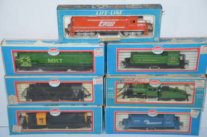
Seven Different Running Diesel Locomotives-Life-Like/Model Power-HO ScaleJM Hobby Supply and Railroad Artifact Auctions4.4(126)See Sold PriceFeb 25, 2024
Vintage County Map Of NY State Plate EngravingThe Benefit Shop Foundation Inc.4.3(2.9k)See Sold PriceFeb 28, 2024
1818 RARE Geography Made Easy MAPS Jedidiah Morse Boston Indians Atlas AsiaSchilb Antiquarian Rare Books4.8(421)See Sold PriceMar 31, 2024
Thirty Pieces of Lackawanna Railroad Ephemera - Chief Engineer Timebook, Map, Public Timetables,Rail & Road Auctions4.6(165)See Sold PriceMar 07, 2024
Pair of Early Railroad Maps - 1874 Delaware, Lackawanna & Western and 1876 Pennsylvania RailroadRail & Road Auctions4.6(165)See Sold PriceMar 07, 2024
Group of Ten Railroad Photographs, Maps, and Prints - New Jersey, Long Island, and New YorkRail & Road Auctions4.6(165)See Sold PriceMar 07, 2024
Rand McNally Railroad Map Cabinet w/ 21 Railroad MapsRail & Road Auctions4.6(165)See Sold PriceMar 08, 2024
War Diary of 354th Infantry - 89th Division 1919North American Artifact Auctions4.6(182)See Sold PriceApr 20, 2024
[ARCTIC]. BOWEN, Emanuel. A New & Accurate Map of the North...Potter & Potter Auctions4.6(539)See Sold PriceMar 07, 2024
[WORLD WAR II – OKINAWA]. Okinawa Shima Western Beaches Top...Potter & Potter Auctions4.6(539)See Sold PriceMar 07, 2024
[MAP]. NICHOLLS, Sutton (1668-1729). An Epitome of Sr. Will...Potter & Potter Auctions4.6(539)See Sold PriceMar 07, 2024
6" Polished Celt. Black Hardstone. Ex Darin ThomasTony Putty Artifacts4.7(404)See Sold PriceMar 09, 2024
Emory's Notes of a Military Reconnoissance larger issuePBA Galleries4.7(381)See Sold PriceMar 07, 2024
Johnson's Africa. Colonies & tribes. Liberia Nile Delta Cape Colony 1866 mapJasper524.5(9.8k)See Sold PriceFeb 28, 2024
Herman Moll A New Map of Ye North Parts of AmericaWillow Auction House4.5(283)See Sold PriceMar 14, 2024
![[WESTERN MAP] Johnson's 1858 Pocket Map of Missouri First Image](https://p1.liveauctioneers.com/46/20038/6847661_1_x.jpg?height=282&quality=95&width=282)
![[WESTERN MAP] Johnson's 1858 Pocket Map of Missouri (1 of 1)](https://p1.liveauctioneers.com/46/20038/6847661_1_x.jpg?height=282&quality=70)
![[WESTERN MAP] Johnson's 1858 Pocket Map of Missouri First Image](https://p1.liveauctioneers.com/46/20038/6847661_1_x.jpg?height=282&quality=1&width=282)
![[WESTERN MAP] Johnson's 1858 Pocket Map of Missour (1 of 1)](https://p1.liveauctioneers.com/46/23326/8239685_1_x.jpg?height=282&quality=70)


![[ARCTIC]. BOWEN, Emanuel. A New & Accurate Map of the North... (1 of 1)](https://p1.liveauctioneers.com/928/318880/171360917_1_x.jpg?height=282&quality=70&version=1707501302)
![[WORLD WAR II – OKINAWA]. Okinawa Shima Western Beaches Top... (1 of 1)](https://p1.liveauctioneers.com/928/318880/171361141_1_x.jpg?height=282&quality=70&version=1707501302)
![[MAP]. NICHOLLS, Sutton (1668-1729). An Epitome of Sr. Will... (1 of 1)](https://p1.liveauctioneers.com/928/318880/171361281_1_x.jpg?height=282&quality=70&version=1707501302)


