SoldWells (E) A New Map of Present Poland, HunWells (Edward) A New Map of Present Poland, Hungary, Walachia, Moldavia, Little Tartary, shewing their principall divisions, chief Cities, Towns, rivers etceastern Europe from Dantzig to BelgrSee Sold Price
SoldWells (Edward) A New Map fo Present PolandWells (Edward) A New Map fo Present Poland, Hungary, Walachia, Moldavia, Little Tartary &c.,decorative cartouches in upper corners, engraved by Benjamin Cole, with hand-colouring in outline, 3See Sold Price
Sold1718 MAP OF POLAND BY EDGAR WELLS1718 MAP OF POLAND BY EDGAR WELLS 1718 "A New Map of Present Poland, Hungary, Walachia, Moldavia, Little Tartary. Showing their Principall Divisions Chief Cities Torons Rivers & Co. [...] Dedicated toSee Sold Price
SoldWells (E) A New Map of Denmark, Norway,Wells (Edward) A New Map of Denmark, Norway, Sweden, & Moscovy,with A New Map of Ancient Scandinavia together with as much more of ye Northern Part of Ancient Europe, as Answers to Present DenSee Sold Price
SoldWells (E) A New Map of The British IslesWells (Edward) A New Map of The British Isles, shewing their present gen; divisions, cities and such other towns and places, as answer to the towns of note, in the times of the romans, the BriSee Sold Price
SoldA New Map of Present Poland, Hungary, Walachia, MA New Map of Present Poland, Hungary, Walachia, Moldavia Little Tartary hand-colored engraved map 14 3/4 x 20 1/4 inches.See Sold Price
SoldWells (E) A New Map of Iberia, EuropaeaWells (Edward) A New Map of Iberia, Europaea aloas Celtiberia or Ancient Spain, shewing its principall divisions, chief Cities, Towns, rivers, mountains etc, with decorative title cartouche, SSee Sold Price
Wells (E) A New Map of Libya or Old AfrickWells (Edward) A New Map of Libya or Old Africk,Shewing its General Divisions, Most Remarkable Countries or People, Cities, Townes, Rivers, Mountains &c., showing the whole continent, largSee Sold Price
SoldWells (Edward) A New Map of Present Italy, TogetheWells (Edward) A New Map of Present Italy, Together with the Adjoyning Islands of Sicily, Sardinia, and Corsica,engraved map with outline hand-colouring, 370 x 495mm, c.1700 ? Ortelius (AbrahaSee Sold Price
SoldGrp: Maps of Western EuropeLot of seven maps of Western Europe. Includes Edward Wells (1667–1727), "A New Map of Present Germany, Shewing Its Principal Divisions, Cities, Towns, Rivers, Mountains, &c. Dedicated to His HiSee Sold Price
SoldPoland.- Zatta (Antonio) Il Regno di Polonia con lePoland.- Zatta (Antonio) Il Regno di Polonia con le Provincie ora Possedute dalle tre Confinanti Potenze Prussia Russia e Casa d' Austria, map of present-day Poland, Lithuania, and portions of Latvia,See Sold Price
SoldWells (E) Netherlands or Low CountriesWells (Edward) A New Map of The Netherlands or Low Countries, shewing their principal divisions, Cities, Towns, rivers, &c, from Amiens to Emden, with inset map of the ancient coast of HollandSee Sold Price
SoldWells (E) Eastern Parts of Asia MinorWells (Edward) A New Map of The Eastern Parts of Asia Minor Largely Taken as Also of Syria, Armenia, Mesopotamie & c.,with A New Map of Turky in Europe, A New Map of Samartia Europaea PannoniaSee Sold Price
SoldWells (E) The North Part of Antient AfricaWells (Edward) A New Map of The North Part of Antient Africa, Shewing the Chiefe People, Cities, Towns, Rivers, Mountains, & C., in Mauretania, Numidia, Africa propria, Libya propria, and EgypSee Sold Price
Sold[Wells (E)] Islands of the Agæan Sea,[Wells (Edward)] A New Map of the Islands of the Agæan Sea, together with the Island of Crete, and the adjoining Islands,decorative title vignette, engraved map by Sutton Nicholls, with outlinSee Sold Price
SoldEdward Wells Map of Africa 1738Edward Wells (1667-1727), "A New Map of Africk Shewing its Present General Divisions Cheif Cities or Towns, Rivers, Mountains &c," London, ca. 1738. Hand colored map of Africa. With an elaborately decSee Sold Price
Sold(MAP) WELLS, EDWARD. A New Map of Europe ... Dedicated(MAP) WELLS, EDWARD A New Map of Europe according to the Present General Divisions and Names ... Capital Cities, Chief Rivers, Mountains, &c. ... Dedicated to His Highness William Duke of Gloucester.See Sold Price
SoldWells (Edward) A New Map of EuropeWells (Edward) A New Map of Europe according To The Present General Divisions and Names of its Countries together with their Capital Cities chief Rivers Mountains & c.with Ancient Europe and ASee Sold Price
SoldWells (Edward) A New Map of EuropeWells (Edward) A New Map of Europe according To The Present General Divisions and Names of its Countries together with their Capital Cities chief Rivers Mountains & c.with Ancient Europe, andSee Sold Price
SoldAfrica, E. Wells 1720Title: A New Map of Africa Subject: Africa Maker: E. Wells Date: 1720 Materials: Hand colored copperplate engraving Size: 19.75 x 14.5 inches Dedication to the Duke of Gloucester Please note that thisSee Sold Price
Sold2 Maps of Asia by Edward WellsGroup of two maps of Asia by Edward Wells (1667–1727): "A New Map of the East Indies" and "A New Map of Present Asia," both dedicated to William, Duke of Gloucester. SKU: 03486See Sold Price
SoldWELLS, EDWARD. [A New Sett of Maps Both of Antient andWELLS, EDWARD. [A New Sett of Maps Both of Antient and Present Geography.] 37 and a half (of 41) double-page engraved maps (lacking title, preliminary leaf, A New Map of Europe, A New Map of Present SSee Sold Price
SoldA New Map of the Terraqueous Globe according to theA New Map of the Terraqueous Globe according to the Ancient Discoveries. Kol. Kupferstichkarte von E. Wells nach M. Burghers aus "A New Sett of Maps". Oxford, um 1701. 37,6 x 51,5 cm (40,7 x 54 cm).WeSee Sold Price
SoldWells, Edward. A New Map of Gallia Cisalpina & Graceia(London: E. Wells, n.d., early 18th century), copperplate engraving with outline color showing northern Italy and the country's extreme south. From A New Sett of Maps as dedicated to the Duke of GloucSee Sold Price
1892 Adams and Bowles New Road Map of the State of New YorkJM Hobby Supply and Railroad Artifact Auctions4.4(126)See Sold PriceFeb 24, 2024
Elgin Joliet and Eastern RR Dressel Switch LampJM Hobby Supply and Railroad Artifact Auctions4.4(126)See Sold PriceFeb 24, 2024
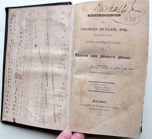
Charles Butler Ancient & Modern Music 1824 1st Edition Scarce MusicLuis Porretta Fine Arts4.3(10)See Sold PriceMar 02, 2024
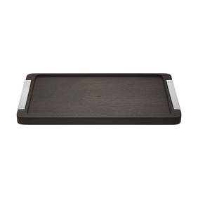
Bernadotte by Georg Jensen Stainless Steel and Smoked Oak Serving Tray - NewBidhaus4.3(747)See Sold PriceFeb 23, 2024
Johann Homann Hand-Colored Map Engraving, c. 1730Auctions at Showplace4.5(726)See Sold PriceMar 17, 2024
Arrowsmith & Lewis - Map of North AmericaTrillium Antique Prints & Rare Books4.5(30)See Sold PriceFeb 24, 2024
Arrowsmith & Lewis - Map of the United StatesTrillium Antique Prints & Rare Books4.5(30)See Sold PriceFeb 24, 2024
10PC 1978 Kenner Star Wars Group incl. DT LukeBruneau & Co. Auctioneers4.5(491)See Sold PriceFeb 24, 2024
1855 NOTES ON CENTRAL AMERICA by E. G. Squier antique w/ MAPSJasper524.5(9.8k)See Sold PriceFeb 27, 2024
1738 BIBLE in DUTCH ILLUSTRATED w/ MAPS antique MASSIVE FOLIO BIBLIAJasper524.5(9.8k)See Sold PriceFeb 27, 2024
Kent & Sussex.- Moss (W.G.) The History and Antiquities of the Town and Port of Hastings, 1824; andForum Auctions4.3(52)See Sold PriceFeb 29, 2024
1750 Bowen Map of Bermuda and St. Kitts -- A New & Accurate Map of Bermudas or Sommer's Islands...Jasper524.5(9.8k)See Sold PriceFeb 27, 2024
LE CARRE JOHN: (1931-2020)International Autograph Auctions Europe S.L.4.5(52)See Sold PriceMar 14, 2024
Robert H Labberton - Map of The Territory of the Present United States - The territory of theProverde Auctions4.3(3)See Sold PriceFeb 28, 2024