Wall map of California & Nevada
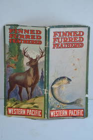
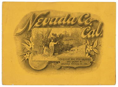
Western Pacific RR Finned Furred Feathered Brochure-1912Feb 24, 20245ft Original1857 Steuben County NY Wall MapFeb 24, 2024Vintage Vanguard Studio wall map, dated 1968Feb 25, 2024Bernhardt Wall (CA,1872-1956) watercolor painting antiqueMay 05, 2024Mexico, Central America and the West IndiesFeb 27, 2024Mexico, Central America and West Indies Physical PoliticalFeb 27, 2024Promotional book for Nevada County, CaliforniaMar 07, 2024Large map of California & Nevada 1907Mar 07, 2024Johnson's California & West hand-colored map 1861Mar 07, 2024Large folding map of Mariposa County 1914Mar 07, 2024Robert Cormack cartoon map of the Mother Lode c.1931Mar 07, 2024Wall map of San Francisco 1902Mar 07, 2024Climatology map of California 1903Mar 07, 2024Seale map of North America California an islandMar 07, 2024Wall map of Solano County, California 1915Mar 07, 2024Large wall map of Windham Connecticut 1856Mar 07, 2024Large wall map of U.S. & Central AmericaMar 07, 2024Wall map of North America 1856Mar 07, 2024Grapho-Politico wall map of California 1902Mar 07, 2024MAP, California, OwensMar 12, 2024MAP, California, RinggoldMar 12, 2024MAP, California, BancroftMar 12, 2024MAP, California, SoCal Edison Co.Mar 12, 2024