MATTHEWS c1856 Map Of Upper Canada Ontario Indian Land Agency Divisions Scarce!Luis Porretta Fine Arts4.3(10)See Sold PriceMar 02, 2024
DEVINE c1856 Dr Salters Map Of Lake Huron Ontario Indian Lands etc. No. 7 ScarceLuis Porretta Fine Arts4.3(10)See Sold PriceMar 02, 2024
DUNLEVIE c1856 Map Counties Of Gaspe & Bonaventure Quebec Canada SCARCE! #1Luis Porretta Fine Arts4.3(10)See Sold PriceMar 02, 2024
DUNLEVIE c1856 Map Counties Of Gaspe & Bonaventure Quebec Canada SCARCE! #2Luis Porretta Fine Arts4.3(10)See Sold PriceMar 02, 2024
Map UNITED COUNTIES LEEDS & GRENVILLE by Walling 1861 Rare Canada Map 5ft x 5ftLuis Porretta Fine Arts4.3(10)See Sold PriceMar 02, 2024
Ambroise TARDIEU c1822 Map Venice Napoleon Italian Campaign 17" x 11"Luis Porretta Fine Arts4.3(10)See Sold PriceMar 02, 2024
SoldVintage nautical navigational chart: East CoastVintage nautical navigational chart: Halifax to Hispaniola Including the Bahamas & Greater Antilles. Circa 1962. 48 3/4"h x 34 1/2"wSee Sold Price
SoldVintage nautical navigational chart West IndiesVintage nautical navigational chart West Indies Grand Bahama Bank. 33"h x 42 1/2"wSee Sold Price
SoldNautical Map / Sea Chart, #1212 Eastern Long IslandDescription: Nautical Map / Sea Chart, United States East Coast, Connecticut - New York, Long Island Sound, Eastern Part, 12th edition feb 10 / 69 ; all measurements are approximate; Folded; ShippingSee Sold Price
SoldNautical Map / Sea Chart, #1211 MarthaDescription: Nautical Map / Sea Chart, United States East Coast, Rhode Island - Connecticut - New York, Block Island Sound and Approaces9th edition, dec 23/63 stamped CORRECTED ONLY FOR AIDS & HAZARDSSee Sold Price
SoldNautical Map / Sea Chart, #362 Block Island Sound andDescription: Nautical Map / Sea Chart, United States East Coast, New York, Long Island, Block Island Sound and Gardiner's Bay, 6th edition, Feb 10/69; Shipping: $20; different rate to California, AlasSee Sold Price
Nautical Map / Sea Chart, #359 New London HarborDescription: Nautical Map / Sea Chart, United States East Coast, Connecticut - New York, Thames River, New London Harbor, Long Island Sound to Norwich, 22nd edition, june 9/69; Shipping: $20; differenSee Sold Price
Nautical Map / Sea Chart, #362 Block Island Sound andDescription: Nautical Map / Sea Chart, United States East Coast New York - Long Island Block Island Sound and Gardiners Bay 2nd edition oct 15th/62 edition, stamped knutson marine center inc. mill damSee Sold Price
Nautical Map / Sea Chart, #1210 MarthaDescription: Nautical Map / Sea Chart, United States East Coast, Massachussets - Rhode Island, Martha's Vineyard to Block Island, 12th edition dec 16/68; Folded; Shipping: $20; different rate to CalifSee Sold Price
Nautical Map / Sea Chart, #269 Block IslandDescription: Nautical Map / Sea Chart, United States East Coast, Rhode Island - Block Island, 1st edition july 7 /52 ; revised 6/25/56, stamped "huntington hardware corp agents for U.S coast & geodetiSee Sold Price
Nautical Map / Sea Chart, #214 Niantic BayDescription: Nautical Map / Sea Chart, United States East Coast, Connecticut - North Shore of Long Island Sound, Niantic Bay and Vicinity, 5th edition nov 26/62, stamped Knutson Marine Center Inc, MilSee Sold Price
Nautical Map / Sea Chart, #224 Oyster & Huntington BaysDescription: Nautical Map / Sea Chart, United States East Coast, New York, Oyster & Huntington Bays, South Shore of Long Island Sound, 3rd edition feb 1/43; revised 11/30/59 CORRECTED THROUGH NOTICE TSee Sold Price
Nautical Map / Sea Chart, #1212 Long Island Sound -Description: Nautical Map / Sea Chart, United States East Coast, Connecticut - New York, Long Island Sound East, New London Harbor, Long Island Sound Eastern Part, 8th edition Jul/29/63 stamped w/ NOTSee Sold Price
Nautical Map / Sea Chart, #1212 Long Island Sound -Description: Nautical Map / Sea Chart, United States East Coast, Connecticut - New York, Long Island Sound East, New London Harbor, Long Island Sound Eastern Part, 8th edition Jul/29/63 stamped w/ NOTSee Sold Price
Nautical Map / Sea Chart, #1211 MarthaDescription: Nautical Map / Sea Chart, United States East Coast, Rhode Island - Connecticut - New York, Block Island Sound and Approaces9th edition, dec 23/63 stamped CORRECTED ONLY FOR AIDS & HAZARDSSee Sold Price
Nautical Map / Sea Chart, #358 FisherDesription: Nautical Map / Sea Chart, United States - East Coast Rhode Island - Connecticut - New York ; Folded; 12th edition Aug 6/62; Shipping: $20; different rate to California, Alaska, Hawaii & alSee Sold Price
Nautical Map / Sea Chart, #224 Oyster & Huntington BaysDescription: Nautical Map / Sea Chart, United States East Coast, New York, Oyster & Huntington Bays, South Shore of Long Island Sound, 3rd edition feb 1/43; revised 11/30/59 CORRECTED THROUGH NOTICE TSee Sold Price
Nautical Map / Sea Chart, #358 FisherDesription: Nautical Map / Sea Chart, United States - East Coast Rhode Island - Connecticut - New York ; Folded; 12th edition Aug 6/62; Shipping: $20; different rate to California, Alaska, Hawaii & alSee Sold Price
Nautical Map / Sea Chart, #362 Block Island Sound andDescription: Nautical Map / Sea Chart, United States East Coast, New York, Long Island, Block Island Sound and Gardiner's Bay, 6th edition, Feb 10/69; Shipping: $20; different rate to California, AlasSee Sold Price
Nautical Map / Sea Chart, #224 Oyster & Huntington BaysDescription: Nautical Map / Sea Chart, United States East Coast, New York Long Island, Oyster & Huntington Bays, 8th edition Dec 2/68; Folded; Shipping: $20; different rate to California, Alaska, HawaSee Sold Price
Nautical Map / Sea Chart, #1212 Eastern Long IslandDescription: Nautical Map / Sea Chart, United States East Coast, Connecticut - New York, Long Island Sound, Eastern Part, 12th edition feb 10 / 69 ; all measurements are approximate; Folded; ShippingSee Sold Price
Nautical Map / Sea Chart, #1210 MarthaDescription: Nautical Map / Sea Chart, United States East Coast, Massachussets - Rhode Island, Martha's Vineyard to Block Island, 12th edition dec 16/68; Folded; Shipping: $20; different rate to CalifSee Sold Price
Nautical Map / Sea Chart, #362 Block Island Sound andDescription: Nautical Map / Sea Chart, United States East Coast, New York, Long Island, Block Island Sound and Gardiner's Bay, 6th edition, Feb 10/69; Shipping: $20; different rate to California, AlasSee Sold Price
Nautical Map / Sea Chart, #1210 MarthaDescription: Nautical Map / Sea Chart, United States East Coast, Massachussets - Rhode Island, Martha's Vineyard to Block Island, 12th edition dec 16/68; Folded; Shipping: $20; different rate to CalifSee Sold Price
Nautical Map / Sea Chart, #358 FisherDesription: Nautical Map / Sea Chart, United States - East Coast Rhode Island - Connecticut - New York ; Folded; 12th edition Aug 6/62; Shipping: $20; different rate to California, Alaska, Hawaii & alSee Sold Price
Robin Hotchkiss Oil Surrealist Sculpture Painting on vintage Chevrolet Center Wheel CapCollective Hudson4.5(54)See Sold PriceMar 01, 2024
Native American Pair of Vintage Early - Mid 20th Century Beaded MoccasinsCollective Hudson4.5(54)See Sold PriceMar 01, 2024
Vintage French Art Deco Modernist Side End Tables, Circa 1940Collective Hudson4.5(54)See Sold PriceMar 01, 2024
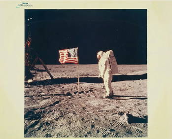
Vintage Photograph of APOLLO 11: BUZZ ALDRIN & OLD GLORY ON THE MOON Chromogenic Color Photograph,Collective Hudson4.5(54)See Sold PriceMar 01, 2024
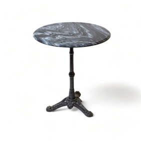
Estate Vintage Louis XV-Style Finely Carved Giltwood Gueridon or center tableCollective Hudson4.5(54)See Sold PriceMar 01, 2024
Vintage Louis Vuitton Monogram Brown Leather Duffle BagCollective Hudson4.5(54)See Sold PriceMar 01, 2024
Vintage Louis Vuitton Monogram Brown Leather Duffle BagCollective Hudson4.5(54)See Sold PriceMar 01, 2024
Vintage 800 Silver Hand Hammered (4 pc) Arts and Crafts Movement Tea SetCollective Hudson4.5(54)See Sold PriceMar 01, 2024
Tiffany and Co Signed 18k Gold Vintage Knot EarringsCollective Hudson4.5(54)See Sold PriceMar 01, 2024
Southern Africa Cape of Good Hope-Madagascar ADMIRALTY sea chart 1935 (1955) mapJasper524.5(9.8k)See Sold PriceFeb 28, 2024
Gulf of Guinea. Ghana Togo Benin Nigeria. ADMIRALTY sea chart 1928 (1954) mapJasper524.5(9.8k)See Sold PriceFeb 28, 2024
South Namibia coast. Walvis Bay-Orange River ADMIRALTY sea chart 1881 (1954) mapJasper524.5(9.8k)See Sold PriceFeb 28, 2024
CHARTS: United States - East Coast New Jersey/ PASSAIC AND HACKENSACK RIVERSChurchill Galleries3.7(213)See Sold PriceFeb 26, 2024
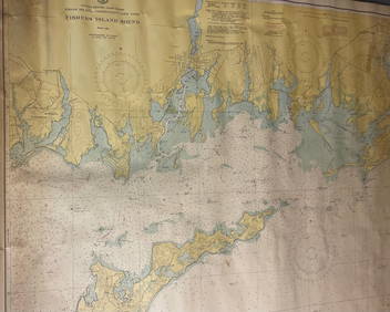
CHART: UNITED STATES - EAST COAST/ RHODE ISLAND - CONNECTICUT - NEW YORK/ Fishers IslandChurchill Galleries3.7(213)See Sold PriceFeb 26, 2024
CHART: UNITED STATES - EAST COAST MASSACHUSETTS/ HYANNIS HARBORAND VICINITYChurchill Galleries3.7(213)See Sold PriceFeb 26, 2024
Chart: United States- East Coast/ NORTH CAROLINA/ RIVER INLET TO CAPE FEAR.Churchill Galleries3.7(213)See Sold PriceFeb 26, 2024
CHART: UNITED STATES - EAST COAST NEW YORK/ HUDSON RIVER/ POUGHKEEPSIE TO HUDSONChurchill Galleries3.7(213)See Sold PriceFeb 26, 2024
10 Vintage New Jersey Florida East Coast Central Railroad Uniform ButtonsRapid Estate Liquidators and Auction Gallery4.5(1.1k)See Sold PriceFeb 24, 2024
Vintage Florida East Coast 405 12" EngineRapid Estate Liquidators and Auction Gallery4.5(1.1k)See Sold PriceMar 02, 2024